#roach makes travel faster but Yennefer has it MADE with portaling
Explore tagged Tumblr posts
Text
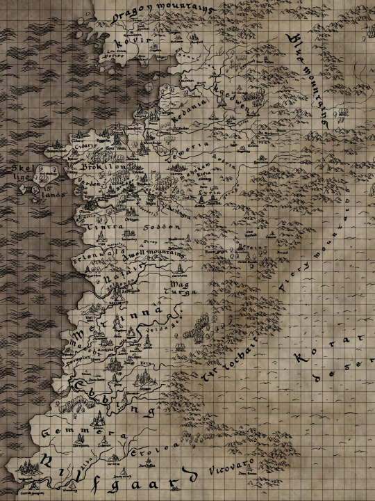
The Witcher Scaled Map
So because I like to do too much
I created a scaled map of The Continent where each one of the individual lines represents 12 miles (19.3 km)

I hope this is useful to everyone for their headcanons, fanfictions, roleplaying, shitposts, art, whatever you need this for!
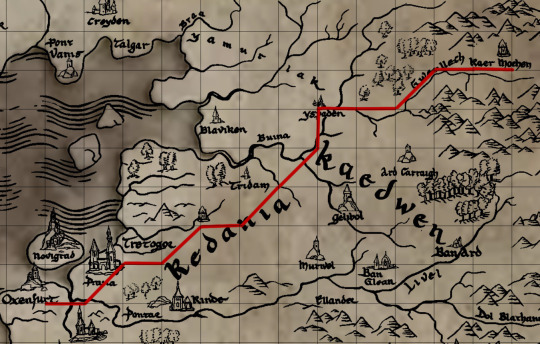
For example, ever wanted to know the distance between Oxenfurt and Kaer Morhen?

It’s roughly 180 miles so we are talking a 4-5 day journey minimum on horse. A human walking alone would probably take closer to 9 days. (the diagonals are roughly 17 miles -- found using some quick math). If you want to go further you could also consider the impact of terrain, eating, character stamina, etc. This just gives a really good base for any worldbuilding.
Feel free to use this map! If you end up using it for something, it would be awesome if you could link them back to this map.
Also, if you want to calculate travel time but don’t want to do the work of figuring it all out, then feel free to send in an ask letting me know the where (Aretuza to Rinde, etc) and how they are traveling (by foot, by horse, by horse-drawn wagon).
Note that some of the s2 locations aren’t on this map quite yet because they haven’t released an image, they just have the interactive map on the website but I could still easily calculate out those locations too such as Melitele’s Temple and Nivellen’s Mansion if you’d like.
under the cut are some more details about how I came up with this map.
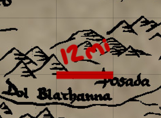
It was difficult to figure out where to start --- we rarely get any time indicators of characters traveling but in S1E2 Geralt and Jaskier walk out to Dol Blathanna so I figured that would be a good place to start.

The first shot of the Inn at Posada (and wow what a cool design we do NOT talk about how fucking cool this looks enough) it seems to be early in the day. Jaskier is just starting his set, people seem to be eating. The light seems to be just peaking out from behind the mountains. So I’m putting the beginning here early on in the day.

Then in this shot they are about to meet the Elves and it seems to be later in the day now, closer to afternoon. I think it’s fair to say that walking from the Inn at Posada to Dol Blathanna took a few hours. I am going to stay on the safe side and guess around 3 hours. I can’t imagine that Geralt would let this bard follow him around longer than that and I have trouble believing Jaskier would walk longer than that -- it seems a stretch to think he’d follow Geralt around for 3 hours as is -- he just met the guy. Now Roach seemed to be happily walking the entire time and a horse’s average walk is around 4 mph while a human’s is around the same. This means that Dol Blathanna to Posada is around a 12 mile walk (19.3 km).
Now using my handy-dandy map I can create a grid system where each small line on the grid is equivalent to around 12 miles.

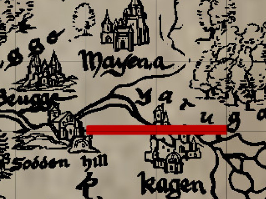
This scale is backed up by the fact that Vilgefortz in S1 E8 stated that the armies of Temeria and Kaedwen were in the Yaruga Valley 2 days away and using this map scale the distance between Sodden Hill and Yaruga is around 24 miles (in a straight line so it could be more or less with actual troop movement) and medieval armies would march around 12 miles a day on the faster end. That makes up about 2 days.

So this is a good map for figuring out how far away everything is in The Witcher and I will be using it to come up with my timeline for S2!
#the witcher#the witcher map#twn#geralt#roach makes travel faster but Yennefer has it MADE with portaling#myposts#the witcher netflix#also no I'm totally not using this to write more of my fic that I thought I would never write more of
735 notes
·
View notes