#on uneven ground with no tools except two tape measures a compass a string and some nails
Explore tagged Tumblr posts
Text
Most people have probably been culturally exposed to archaeology enough to know excavation is done on a grid, but for extra context I'll go into the lesser-known "You've Heard of First Grid, What About Second Grid" techniques.
For sites thick with cultural material like debitage (flakes of stone from knapping stone tools, which can number in the thousands in a single 1x1 metre square in sites I've worked at), or with very difficult conditions or soil matrix (like above), or sites that are excavated commercially and need to be done speedily, the site is divided into a grid of numbered units (1x1 in North America usually), and each of those units can be further subdivided in its own smaller 3-dimensional grids of area and depth.
These divisions can vary widely based on the needs and preferences of the archaeologists, but it means that each section of dirt is removed methodically and seperately, given its own paperwork and ID tags that record exactly where and how deep it came from, the day it was excavated, drawings and notes and everything, and packed up all nice and neat (ha! Sorry, lil joke. Fun fact: sharpie pens are as useless to write with in the rain as uncooked linguini), for processing later.
Functionally, this means that every section of dirt removed in this way has as much contextual information recorded as the archaologists in charge deemed necessary for the material and research. Even once washed and sorted, any material found in each seperate section can be "placed" in the 3-dimensional location of the site from which it was removed.
You still record in situ artifacts as you find them, such as large bones, tools, diagnostic artifacts, features like post holes, firepits, building remains, etc., and those all get the same context info recorded too. But for statistical analysis of things like soil composition, pebble size and distribution, or hundreds/thousands of tiny bone fragments or stone chips, processing that is just much, much more efficiently done in the lab than in the field. You record everything you can, but the field is messy and it is too easy for things to get lost or mixed up together. Bag it and tag it, is the motto of field work.
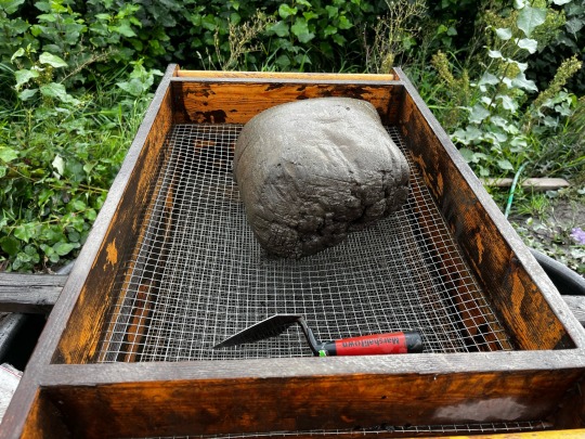
I hope this allays some concerns about how context is still kept for things like the Chonk 'o Clay XD

No problem; just push it through the screen!
#You ever dropped an artifact in the dirt at your feet and it clips thru the fucking map bethesda style#Lot harder when that sucker is properly bagged up right away!#Anyway yeah archaeologists fucking love grids we can talk about grids all day#Ask us about grids and hypotenuses and how to lay an accurate north-facing grid#on uneven ground with no tools except two tape measures a compass a string and some nails#I worked on a project that got funding for a phd student's research on digital site recording and we used a *GPS tower with 3cm accuracy*#It. Was AMAZING. Our lines were so straight. Our walls PRISTINE.#My team still had to use the transit level to take our depths each day#cuz we were on the side of the hill that got interference from the cell tower so the gps took way too long to sync there#But we used it to lay down the grid for new pits and i felt so spoiled lol. We double checked it of course but like. It was so fast.#and the students needed to practice on the transit level anyway so that worked out just fine
1K notes
·
View notes