#last time I rebuilt the paths & added water so the village looked like it was floating on a lake
Explore tagged Tumblr posts
Text


my minecraft play style is find the nearest village & rob it of its personality
#and by that I mean clear it out so I have a blank slate to beautify lol#last time I rebuilt the paths & added water so the village looked like it was floating on a lake#I lost that save sadly.....perhaps I'll try it again here................#fishatalks
3 notes
·
View notes
Text
oh, i ended up spending so much time on this, but - it’s done ! it’s far from perfect but i’m pretty satisfied that there’s a visual guide to my idea of hyrule, post-seven years war. & now, god help you all, i’m gonna talk about it lmao. click here if you want to see a full-sized version of the map, but i’m also gonna put it under the cut in this post with the original map for comparison, & go on for a bit about how hyrule has, in my interpretation, changed under zelda’s rule.
( this gets long. like, really long. like, over 4,500 words long. read at your own risk. i’d say i’m sorry, but i’m really not. & fuck drawing water features forever. )
first thing’s first - the map !
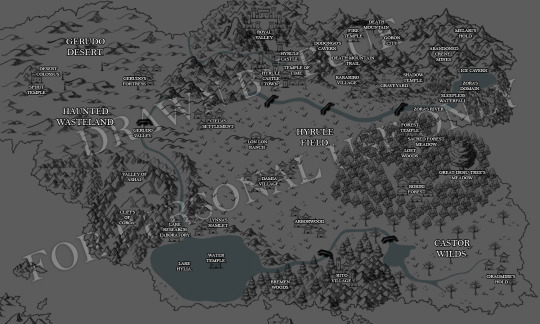
( apologies for the giant watermark underneath it all but i’ve had my shit stolen before & i’m not enthused at the idea of having it happen again. clicking it open in a new tab should make it bigger if the link above doesn’t work. )
so, it’s slightly bigger than the original map which is featured in the game, haha. here’s a comparison of the two, actually, with my map over the top of the original so you can see what’s been changed or added & where. i’ll talk about what got added & why in a bit, i want to speak just about the actual map, first.
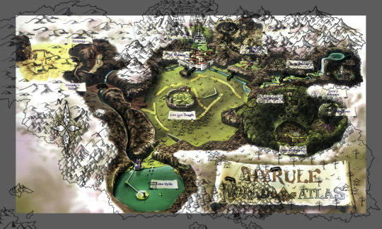
i did my best to keep the main locations of hyrule as specified in the game in the same place, & i think did an okay job, tbh ! my biggest nitpick was just how many dang cliffs & rockfaces there are on the original map. i know they serve a purpose in-game, which is completely fair, but they limited worldbuilding a little by making the map so small, so i took some liberties. not with every cliff, of course - i kept some in the southwest to keep the border between gerudo valley & hyrule field intact, & kept the ridge the river runs through - partly for the sake of continuity, & partly because i’ve always loved the fact that falling into the river in the valley washes you down to the lake. expanding them into a new area was fun, too, because at least then they go somewhere, rather than just locking you in to a certain place.
my main point of contention, to be honest, was the giant rockface in south hyrule field. again, i understand why it was there, but, come on ! so i ended up just doing away with it all, letting it lead a path to two new areas i’d like to work into zelda’s canon. the map just fades out in certain places, too, particularly the gerudo desert, so i ended up expanding that a little more & having it lead into the cliffs above lake hylia - the river already runs from the valley to the lake, so why not have more of the desert lead into the mainland ? the mountains, too, got their range expanded, because they just seem so ... small, in canon, when they aren’t being used specifically as dungeon locations. i’d say the only place on the map i didn’t expand in some way is that little gap between zora’s domain & the kokiri forest - the forest is so hemmed in & the domain is literally inside a mountain, hidden behind a waterfall, so i was happy to just let that be empty space. if you manage to climb over the cliffs surrounding the domain, or break through the treetops in the forest, you get a view of the ocean, & that’s that !
it was fun to look at the maps of the games that came chronologically before this one & see how the position of things in hyrule change, but i’m kind of glad that there was only the three before ocarina of time, because the mountains alone move across the map at their leisure, good god. there was a bit of freedom in it, too, because in zelda’s canon timeline, the gods are going to flood hyrule anyway, so i could make whatever changes i wanted because it’s all gonna end up underwater & unseen in the end - plus, it meant i could add in more mountains to take up empty space on the map, because the hylians have to flee somewhere to escape the flood, & i don’t think the peak of death mountain could hold them all. most of the new locations were inspired by the minish cap, more than any other, so i’m going to start at the top of the map & move down to talk about them.
i always loved royal valley & the royal crypt in the minish cap, to be honest. it was spooky & cute, & i’m surprised it, or a concept like it, hasn’t made much of a comeback in later zelda games. the royal family’s tomb being in kakariko village never bothered me much as a kid ( other than the fact their headstone gets utterly destroyed & you get assaulted by what we can only assume are the zombies of previous hylian rulers ??? & then it’s just left open for anyone to stumble in & possibly loot slash get murdered by said zombies ??? actually, y’know what, this bothers me a lot more as an adult, what the fuck - ) but kakariko was a village founded by the sheikah, originally for the sheikah, so i did always find it a little strange that at some point, a ruler of hyrule went ❛ that’s cool, you do you, but make space for us in your graveyard. ❜ i know the history between the hylian royal family & the sheikah is implied to be murky ( thank you, shadow temple ) but that’s a meta for another day, so i’m not gonna go into too much detail, but it’s still something that sticks out as strange to me. call it the sheikah continuing to guard the royal family in death or whatever, but, hm. weird. anyway !
the point is, after the seven years war ends, zelda decides that what originally belonged to the sheikah should be given back to the sheikah. kakariko village was opened up to non-sheikah by impa prior to the rise of ganondorf, & that’s her perogative & not something zelda would ever dream of interfering with, but that applies to the living, & those who die within the village deserve to be buried in the same place. it takes time to get around to the rebuilding of hyrule castle & its’ town, but when it’s time to plan for it, zelda chooses to utilize the abandoned valley which lies behind the castle as the new home for the royal crypt, but not solely for that ! she establishes & sponsors a university on behalf of the royal family, with special consideration going to the preservation of hylian history ( a lot was lost in the hyrulean civil war prior to her birth, nevermind the seven year war following that so quickly, & we can see in other zelda games, such as twilight princess & breath of the wild, historical preservation within hyrule is ... terrible, to say the least. of course, it will all be washed away when the goddesses flood hyrule, but fuck, at least she tries. ) the university also covers a range of other subjects, but history is the one zelda takes an active interest in, & she spends a lot of time with scholars who specialize in it. the royal crypt lies at the very back of the valley, the university being closer to the castle, & then ... watch this space ! i’m likely to add more things to areas around the map in the future.
hyrule castle & hyrule castle town i’ve left in the same spots, pretty much - i imagine the castle is rebuilt to be something like the one we see at the bottom of the ocean in wind waker, but i intend to put my own spin on that, too. zelda wouldn’t be focused too much on getting a castle up agaiin ( i’ve mentioned in a thread before that two years post-ganondorf, she is still sheltering at impa’s house in kakariko village, as rebuilding for the civilians is her main priority, & whilst i haven’t figured out exactly how long that lasts for, it’s a safe bet to say a good few years ) & she definitely wouldn’t want to be living anywhere especially y’know, grandiose & opulent, if her people were still struggling day to day. the castle town bounces back better than ever, expanding a little more to the left over time, but that’s a gradual thing. no real change except a distinct lack of redeads, which is always a bonus !
death mountain & its immediate surroundings, i was happy to leave as they are - it’s marginally wonky in place compared to the original map but it’s not a severe drift from canon, so lets just pretend it sits a little more to the left, shhh. it’s a volcano built into a mountain with a network of caves both inside & adjacent to it, plus a place of worship built into the heart of it, & you can’t really go wrong with that, so i focused on all that empty space beyond them left on the map. minish cap came in clutch again, because by fuck, did they have a mountain range, so i ended up dipping in to it for the names of this one. the gorons are clustered at the forefront of the mountain because everything beyond their city has been mined to the absolute death by those who came before for its resources, & abandoned by the same in turn, but they still send patrols to make sure it’s fine.
there’s a story of how, before the gorons settled into the mountain, a man of great strength climbed the mountain alone to make his home within it - he faced eruptions from a then-hostile death mountain, fought off the creatures who called the range home & weren’t fond of sharing, & forged on to what was said to be the edge of hyrule itself. it wasn’t, not quite, but it was far enough away from the central provinces of the kingdom that the mountains became capped with snow, contrasting the temperate mountains to the west. the story goes that the adventurer decided to call the furthest reaches of the mountain home, & singlehandedly carved out what would become the beginning of the mines, in order to gather materials for his forge. it’s been disputed whether said man was hylian or goron, as the biggoron family claim lineage from him, but the mountains he once inhabited are named for him now, & are one of the places zelda hid whilst on the run & masquerading as sheik - despite the extreme temperatures playing havoc with her & nearly killing her, it’s one of the harder to reach spots in hyrule, so it provided a measure of safety that other places could not. melari’s hold lies in the northeast, but the cold spot on the mountain travels further south than would be expected, resulting in a cold spot - the ice cavern - to the north of zora’s domain.
real quick, fuck zora’s domain. there was no way to make the water feature coming from here look decent, or properly portray the types of cliffs it’s surrounded by, so please don’t judge it too harshly. at the end of ocarina of time, zora’s domain is still said to be frozen, but recovering from the curse ganondorf placed on it, which, great ! i’m gonna say, i could be completely off here in how it works, but i wanted to change things up a little, so if i am, i don’t mind that much. i like a bit of artistic license. also, if we can have literal fish people, a genderless species made of rock, children who don’t grow up in a magical forest which horrifically warps those who don’t belong, & a giant fucking overworld field where the skeletons of what look like fucking children come out to fight you at night ? i’m okay with this reckoning being off a little.
so, eventually, zora’s domain unfreezes. i personally imagine, as ganondorf’s power ebbed from hyrule, that the process started slow, until one day, it wasn’t. it’s said that zora’s fountain is the source of all water in hyrule, with the domain lying under the mountain it rests on top of, & a few secret passageways here & there, which is fine, usually - the fountain never froze, just the domain beneath it. that becomes a problem, though, when the magical freeze put in place by ganondorf wears off, & the excess water from the melt ends up flooding the domain. not a problem from those who live within it, with the zora being essentially amphibian in nature, but when that excess water begins seeping out into the fountain, through cracks in the mountain, through the entrance granted to those affiliated with the royal family ? that all goes over the fountain, down the sleepless waterfall, through the river, & that river completely bursts its banks. the water level of the river rises significantly, washing away much of the path previously taken by those who wished to go to the domain on foot, causing minor flooding in hyrule field as it travels downstream, & resulting in the waters of lake hylia rising when the overflow reaches it, hence the lake being larger in my version of the map. the rebuilding of a path to zora’s domain ends up becoming one of the earliest projects zelda undertakes as queen but it’s a bit of a logistical nightmare for a while, considering that, with princess ruto ascended as a sage, zora’s domain is now in a succession crisis. does it have much bearing on zelda’s life ? not especially, but i thought it was a nice bit of worldbuilding, so here it is.
kokiri forest, the lost woods, & everything within doesn’t change much. with the dark magic vanquished from the forest, & the great deku sprout able to thrive, the forest continues to grow, & overgrow. it’s still dangerous to outsiders to go within, still dangerous for anyone to enter the lost woods without a fairy companion to guide them & save them from a grim fate, but the children of the forest do grow somewhat braver about stepping out from their home to see the rest of hyrule. it never lasts long - not all of the kokiri are as brave as link was, after all, & hyrule is so vast compared to what they’re used to - but it sparks their curiosity & their desire to explore hyrule which eventually trickles down to the wandering koroks.
the area to the south / southwest of the kokiri forest is entirely my invention. as i said, in-game, it’s just cliffs to hem you in & prevent you from breaking the boundaries of the world, but there’s none of that in roleplaying, so i just … did away with them entirely. part of this is lake hylia not being as hemmed in by these walls as it is in-game, opening up into a new river & streams which travel through the south & southeast. crossing this river leads to three paths - take middle path, & you may find yourself in what’s known as the rito village. now, i’ll say here, i know that the rito don’t technically appear in hyrule until after the great flood, when the zoras somehow sprout wings, but nintendo’s strange decisions don’t change the fact that there are many wonderful people in the zelda rpc who play rito characters with crossover verses that let them interact with those who play characters in other parts of the timeline. in order to better facilitate interactions with these roleplayers, i decided fuck it, rito village in ocarina of time. canon can be easily bent. if, however, i’m writing with someone who wants to adhere to strict canon, then it’s just other hylians who live within the village, & rito is just the name chosen for the village, with no connection to the as-of-yet-unevolved race, just a nice little coincidence. regardless of who lives in it, though, the village & its name are fixed here in a southern woodland, with the village nestled amongst the hills within.
cross the bridge to the south & take the third branch in the path, you’ll find yourself inside the bremen woods. i honestly haven’t got much to say about the bremen woods here, but it’s not because i don’t have ideas for it - i have another headcanon brewing concerning myths, fables & fairy tales within hyrule, because … i am just that type of nerd. about eighty percent of my blogs before this one involved fairy tale characters in some way. it is, as the kids say, extremely my shit, & i’d like to tie the bremen woods into that, so i’m going to save what i have to say for that headcanon, but don’t worry. it’ll probably be a lot smaller than this one. ( thank god, i hear you say. i know, i know. i’m still not sorry. )
cross the bridge, then, & take the first branch in the path, & you better have a sword with you. the castor wilds are a lawless place, which is fitting for the corner of the world where the last remnants of ganondorf’s forces lie. any that weren’t killed during the restoration of the kingdom were beaten back to the edge of the world, & it’s not a friendly place. the last of the monsters shelter in a run-down settlement known as dragmire’s hold, the last place where those who sympathize with the king of evil can speak freely, & it’s murder to get to. the entrance to the wilds is a marshy swamp, thanks to the run-off of lake hylia, but if you manage to get through the mire, the land begins to dry out until you reach the hold, where the earth struggles to bear fruit & it seems the grass refuses to grow. it is, in a few words, fucking grim, & as a result, the go-to place for banishments within the kingdom. zelda isn’t a fan of harsh punishments, but she’s no fool, not anymore, & she won’t abide those who plot to throw the kingdom back into chaos, be it in service of ganondorf, or their own selfish natures. it’s rare that anyone actually finds themselves wandering the castor wilds, unless they actively choose to adventure there, but it is a very good threat, considering its reputation as the land where the devils live.
jumping across the map entirely, we come to the cliffs of coroa to the left of lake hylia. another spot on the map which is notorious for being hard to reach, the cliffs are an inviting challenge to those who want to boast of their climbing skills & durability. if getting up the cliffs doesn’t kill you ( & there is a very real possibility that it will, especially if you fall, ‘cause this water ain’t soft ) the journey down might do it instead, & that’s if you survive your trip at the top. there has been rumours of a great treasure hidden away in the cliffs for years, though the debate on what it might be was pretty intense, if you got into it. for a time, some thought the legendary blade rested within the cliffs, & only those who could brave the rockface would be able to lay a hand on it; others argued that it contained more mundane, but still desirable, treasures, such as a great haul from a band of thieves, left behind when they were hunted down by the crown, growing only more valuable by the minute. some, with sense, said that the only thing atop the cliffs was certain doom for the morons who tried to make their way up them. the truth ? there’s nothing up there. sometimes, cliffs are just cliffs, & those who try to scale the ones facing lake hylia truly are fools. the gerudo people, however, had the right idea of how to get to them.
again, another aspect of canon i was happy to leave as it was. the gerudo desert is a vast, harsh swathe of land, continuously assailed by sandstorms, bordered to the north by what is called ❛ the great sand sea ❜ & to the south by the haunted wasteland, & it’s not hyperbole. spirit guides appear to those who seek the temple of the goddess of the sand, but very few have ever made it through the wasteland if they enter in pursuit of something else. one of the few who did was the gerudo heroine, ashai. a well respected warrior amongst them, ashai was the younger sister to the exalted rishika, the chief of the gerudo at the time, & one of the first to vow to conquer the wasteland & see what lay beyond the storm. though her sister cautioned against it, as tales of people becoming lost in the wasteland were not uncommon, ashai was a headstrong young woman, & she could not be swayed. she took with her a party of twelve, & in time, three returned to tell their story. ashai had forged a path through the ever-shifting sands & left it well enough marked that her companions were able to find their way back. it’s said that some succumbed to madness during the journey, tormented by the ghosts of the wasteland, whilst others fell ill whilst they traveled, choking on the sand which gathered in their lungs. seven of them made it through the wasteland to the valley which lay beyond, but ashai had grown sick during the crossing, & knew she would not make it back. instead, she spent the time she had left exploring the valley, & found a way through it to the peak of the cliffs of coroa. the legend says that is there she died, watching the sun rise atop the cliffs, speaking only of her sister, & her companions laid her to rest within the valley, which her sister then named in honour of her. whilst the gerudo are happy to let those who have proven themselves attempt the journey to the desert colossus, no outsiders are permitted to walk the valley of ashai, where a shrine was built for its namesake - it is considered sacred to them, & the journey to pay respects to ashai is now part of the trial given to those who wish to become chief of the gerudo, should the bloodline of the previous chief die.
that covers just about all the main areas & landmarks of hyrule, i think, so to move on to the last thing, the various settlements, villages, hamlets you see across the map. hyrule is a big place. yes, quite a few of the races are localized to certain areas, & yes, it’s entirely plausible the hyrulean civil war could have decimated the population, with the seven years war exacerbating that problem, but hyrule field just looked so … empty, once everything else was finished. so, rather than stick to a number of locales i can count on one hand, i threw a few more settlements across the map to try & make hyrule feel more like a real kingdom. not to breath of the wild’s extent, of course, but just something a little more than what was given. all those who survived the fall of hyrule castle town apparently fled to become refugees in kakariko village, which was opened to all by impa, which is fair, but i imagine as the world returned to something close to normality, & families started growing again, the village would quickly find itself overwhelmed. as queen, zelda would make it a priority to make sure none of her subjects go homeless - she knows all too well that struggle - & so she would begin a program to make sure there was enough villages or townships for every one of her subjects. those who volunteered would be given a set amount of money & plots of land across hyrule to build a home, which zelda would then personally visit to inspect, to make sure her people were thriving.
there’s little to say in detail about them all as of right now, as i’m still fleshing them out, but i have a few basic ideas. most of the settlements were named after the first to attach themselves to the project, but the names have the potential to evolve over time. they certainly won’t retain the hamlet / settlement status, that’s for sure. the offer wasn’t restricted to hylians, either - any other race in the land was free to join, though only a small number of gerudo accepted it, the others preferring to stay in their homes & travel as they need. ciela’s settlement was the one spearheaded by the gerudo who accepted zelda’s offer, hence its proximity to the valley. a lot of young men volunteered to go to this settlement, but zelda was happy to let ciela make her own call, & many were knocked back - only those with what ciela deemed viable skills were allowed in, & still, it’s very much a female dominated settlement, but it is thriving under her leadership, & blossoms into a successful village as time goes on. lon lon ranch is, well, lon lon ranch. with funding from the crown, talon was able to take on more staff & expand it at his leisure, but it is one of the very few places in hyrule which has stayed constant over time, & he was quite content to keep it that way, & zelda content with his decision.
to the south of lon lon ranch lies damia village, the largest of all the settlements from its inception. led by a fearless young man who gave his name to the village, it is a hub of activity which could rival hyrule castle town. with damia came many like-minded people, all eager to forge their own path in the world & prove themselves as he had, as he had been part of the group which volunteered to help beat back the remnants of ganondorf’s forces. many of the families within damia village are the families of soldiers who work at the castle & it has gained a reputation for being a village full of strong, capable, trustworthy people. arborwood, which lies further to the south in a more rural location, is an outlier in that the one who volunteered to lead in this settlement didn’t wish to put their name to it - they didn’t want glory, just a place to call home where they could finally live in peace. arborwood is an agriculturally focused village, filled with farmers & those who possess green thumbs. a lot of trade is done between arborwood & all the other villages - everyone in hyrule became proficient at growing & hunting their own food in the past thirty years, as was necessary to survive, but it’s nice to have a place to get food from which specializes in high quality meat & crops. why hunt rabbits, when arborwood can provide venison ?
last but not least, lynna’s hamlet, which settled at lake hylia at the request of the owner of the lakeside laboratory. as he was getting on in years, he wished to find someone to continue his work, & so specifically requested that any like-minded hylians settle close to the lake so that he could impart his wisdom & let them take over. he got quite a few more people volunteering than he bargained for, be they scientifically inclined, interested in cataloguing the history of lake hylia, or just desirous of a change in scenery. the smallest of the new settlements, lynna’s hamlet never truly flourished the way others did, but the buildings were never empty - as time went on & people began to move elsewhere, it became a popular spot for those who traveled the land to rest at when they came to the lake, with a very successful inn eventually being run by the lakeside, its doors open to any who wished to visit.
it’s not a lot of worldbuilding when it all comes down to it, compared to other things, but this is something that i’ve wanted to do for a long time. as i’ve mentioned in the section regarding the bremen woods, more headcanons are likely to follow regarding places on the map & how they change & evolve as time passes during zelda’s rule, but for now, there’s this ! something which makes hyrule feel less empty than what it was before, whilst still respecting canon, somewhat which was the goal all along. if you’ve made it this far, holy shit, go outside & feel the sun on your face. it’s been eighty-four years - but i can’t thank you enough for reading ! at least next time, the headcanon won’t be so long. i hope.
#⌜ ❛ ʏᴏᴜ ʙʀɪɴɢ ʏᴏᴜʀ ʜɪsᴛᴏʀʏ & ʏᴏᴜ ʀᴇᴀᴅ ɪᴛ ɪɴ ʏᴏᴜʀ ᴏᴡɴ ᴛᴇʀᴍs. ❜ ⌟ ✦ ( headcanon. )#( eight. eight pages & 4700-odd words of rambling in google docs#i can't believe i spent so much time on this oh my GOD#but it's done !! it's one am & i'm going to bed but i have to get this out into the world before i go#tomorrow i swear i'll get more actual roleplaying done but for now have ... eight fucking pages of THIS i guess#if this is incoherent please let me know good god )
12 notes
·
View notes
Text
Ascending Bhutan’s Sacred Tiger’s Nest
First published on November 30, 2014
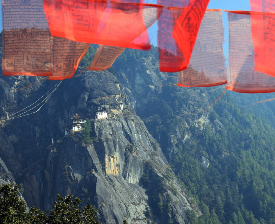
Taktsang monastery on the side of a mountain overlooking Paro Valley in Bhutan. The World Heritage site is featured prominently in the National Geographic book “Sacred Places of a Lifetime,” a showcase of the world’s most powerful and spiritual places. Photograph by David Braun.
PARO, Bhutan–It’s a steep climb to Paro Taktsang, a Himalayan Buddhist monastery hugging the side of a rocky cliff 3,000 feet above the Paro valley in Bhutan. It requires ascending a thousand steps or more, but the path is well constructed and maintained, and the mountain air is fresh and cool. There are plenty of opportunities to stop to admire the spectacular surroundings, making the ascent quite enjoyable if taken slowly.
For those of us who live at sea level it can be difficult to breathe comfortably while exercising vigorously at 10,000 feet, so a relaxed pace with plenty of rest is definitely the way to make this pilgrimage, as advised by our expedition leader, Bill Jones.
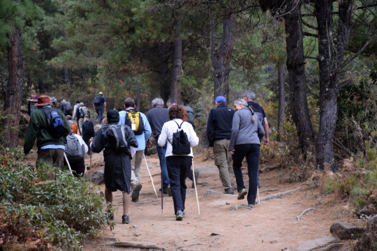
The National Geographic Committee for Research and Exploration at the start of the hike up to Taktsang monastery. Photograph by David Braun.
The pilgrimage to Taktsang, also known as Tiger’s Nest or Tiger’s Lair, is (literally and figuratively) the high point of any visitor’s sojourn in Bhutan. For the National Geographic Committee for Research and Exploration delegation, it was the final stop of a week-long visit that had taken us around the western part of the kingdom, visiting dzongs (monastery fortresses), temples, and the wintering grounds of extremely rare white-bellied herons and black-necked cranes. We’d had plenty of time to acclimate to the altitude and there had been at least two long walks through farms and villages to prepare us for the steep climb to the Tiger’s Nest.
Flying in on a Tigress
Taktsang is said to be the holiest site in Bhutan. It’s where Guru Rinpoche, also known as Padmasambhava, materialized some 1,300 years ago on the back of a flying tigress. Finding shelter in a series of caves, he meditated for some three years and then set about converting the Bhutanese to Buddhism.
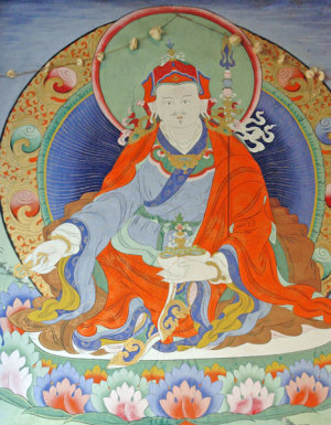
Wall painting of Padmasambhava on Paro bridge. Image by by Baldiri, Wikimedia Creative Commons.
The monastery that commemorates this auspicious beginning was built nine centuries later, in the 1600s, although the buildings we see today have been replaced several times, including major reconstruction completed in 2005 after a fire devastated the structure and its contents in 1998.
Ever taking the long view, the Bhutanese point out that buildings are temporal and meant to be renewed; the ideas and philosophies they represent cannot be destroyed.
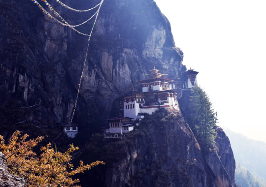
Photograph by David Braun.
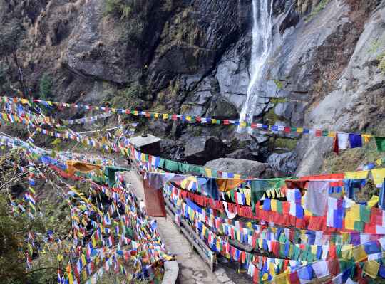
Thousands of prayer flags frame a 200-foot waterfall below the Tiger’s Nest Monastery. Photograph by David Braun.
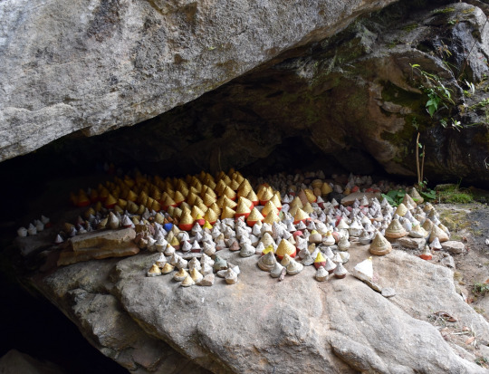
Small reliquaries or “tsa-tsas” containing ashes of the dead on ledges in the vicinity of Tiger’s Nest. Photograph by David Braun.
The final approach to the monastery after a climb of around two hours is over a bridge across a waterfall that drops 200 feet into a sacred pool. The entire area is wrapped in prayer flags, while crevices in the rock are crammed with tsa-tsas, small reliquaries made from ashes of the dead. One last brutal flight of steep steps hewn out of rock delivers pilgrims to the monastery, which for our visit was blanketed in low-hanging cloud, adding an aura of heaven to the place.
Entry to the sanctuary is granted on condition that shoes, cameras, cell phones and other electronic equipment are left at the gates. A security guard patted us down to make sure we were not smuggling cameras and he instructed us to button our jackets as a mark of respect for the holy place. Inside we were given a tour of various temples and other chambers crammed with Buddhist icons and heaped offerings of food and money. Flickering traditional butter lamps cast a warm ethereal light.
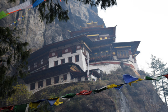
Taktsang’s main structures were rebuilt after a fire all but destroyed the complex 16 years ago. A consortium of international donors restored the site to its former glory in 2005. Photograph by David Braun.
Holy Water
In one temple we encountered a monk watching over a door sealing the cave used by Padmasambhava all those centuries ago. It is opened only once a year in a special ceremony, perhaps like Easter Sunday in the Vatican’s St Peter’s basilica. The monk blessed us and poured saffron-laced water into our hands which we brought to our lips and splashed on the crown of our heads. In the next sanctuary we found a monk chanting sacred texts. He too splashed holy water into our hands for our mouths and heads, and he offered us something to eat.
We were alone in the third room we visited. Our guide stood with us at the door and explained the chamber’s purpose and the iconography on the altar, including a sitting statue of Padmasambhava. Then he invited us to sit quietly on the floor and meditate a while about where we were and what we were seeing and experiencing.
I became conscious of the complete silence of our situation in the clouds thousands of feet up on the side of a mountain deep in the Himalayas.
Cross-legged comfortably on a mat, feet pointed in respectfully, I first thought what a difference it made to be looking at the icons without the encumbrance of a camera. I became conscious of the complete silence of our situation in the clouds thousands of feet up on the side of a mountain deep in the Himalayas.
As I listened to the silence and stared into the fierce eyes of one of the statues my mind shifted abruptly; into my head came the memory of my mother who passed away 34 years ago, and I thought how much she, a Buddhist at heart, would have wanted to visit this remarkable holy shrine. Just then a bird trilled loudly from the ledge of an open window right behind me, and I imagined it was my mother’s way of telling me that she heard me, and that she was with me in this special place.
It is not uncommon for people to have some kind of spiritual experience at Taktsang, Bill Jones, our expedition leader, told me after we had left the monastery. Bill has led groups to Bhutan more than a hundred times, taking perhaps a thousand people up to the shrine. “I can’t tell you how many people have told me that something happened to them spiritually up there,” he said when I told him my story about the bird and thoughts of my mother.
I also learned that the bird that had interrupted my reverie was a rufous-breasted accentor (Prunella strophiata), a common resident throughout the Himalayas. (You can listen to its song here.)
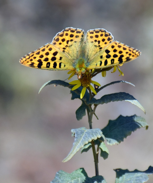
The two-hour stroll up the mountain to Taktsang is through forests of rhododendron and pines, with many birds and smaller animals to be enjoyed. Photograph by David Braun.
Birds are abundant in Bhutan. Everywhere we went we saw crows on houses and monasteries. We learned that schools had been relocated and electricity cables buried to make wetlands safe for the black-necked cranes (Grus nigricollis) that migrate from the Tibetan Plateau, where they breed in the summer.
To make this annual journey, the cranes must fly through extremely harsh conditions over the world’s highest mountains. Residents of Phobjikha say they see the birds circle Gangteng Monastery three times when they arrive at the valley’s marshes for the winter, and three times again when they begin their return. It’s one more spiritual connection between the people and wildlife of Bhutan.
Led by the royal family, the government has committed to protecting Phobjikha Valley for the cranes, and also to keeping more than half of the rest of the country as natural forest. Wildlife corridors have also been set aside for elephants, tigers, leopards, and all the animals smaller than them, to be able to migrate freely between national parks in both Bhutan and neighboring India.
Surrounded entirely by China and India, the two most populous nations on Earth, Bhutan’s isolation and its ancient spirituality have enabled the country to hang on to much of its culture and natural heritage.
But as the country continues to modernize and open to the world, Bhutan will be challenged to stay this way. The teachings brought to Taktsang by Padmasambhava 1,300 years ago include belief in the power and value of nature. Keeping the faith might be what empowers the country to choose the right way forward.
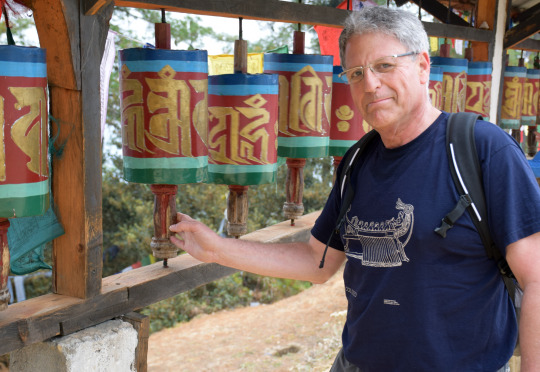
National Geographic President and CEO Gary Knell spins prayer wheels prior to hiking to the Tiger’s Nest monastery. Photograph by David Braun.
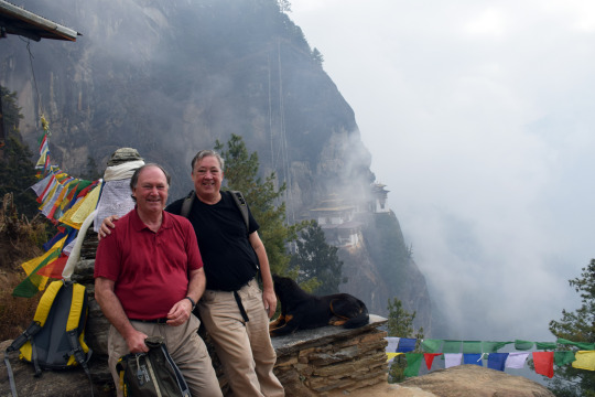
CRE member Keith Clarke (left) and David Braun pause for a photo en route to Tiger’s Nest. We did not know anything about the beautiful dog sitting serenely next to us. Photograph courtesy of David Braun.
National Geographic President and CEO Gary Knell led the Committee for Research and Exploration on a tour of the Himalayan kingdom to meet with grantees, listen to briefings from government officials and environment groups, and observe science, exploration, and conservation in the field. The delegation visited dzongs and other religious places, wildlife sites, and had an audience with King Jigme Khesar Namgyel Wangchuck. The Society has funded nearly two dozen research projects in Bhutan, two of which were active at the time of the National Geographic visit. National Geographic published its first article about Bhutan in 1914: a compelling account of explorations and surveys by John Claude White, a British Raj administrator and an accomplished amateur photographer. Read (and enjoy the 100-year-old photos) here: Castles in the Air: Experiences and Journeys in Unknown Bhutan
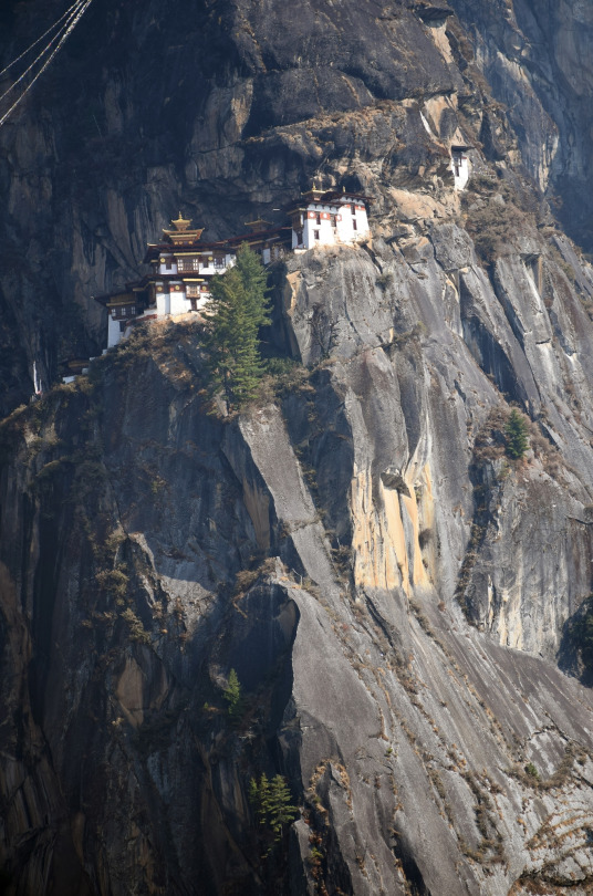
Taktsang is built on a series of ledges on near vertical rock cliffs thousands of feet above Paro. The monastery is some 10,000 feet above sea level. Photograph by David Braun.
#bhutan#taktshang monastery#tiger’s nest#paro#world heritage site#national geographic#guru rinpoche#padmasambhava#buddhism#prayer flags#himalayas#birds
0 notes
Text
Labor of Love
Have you ever painted your house?
I believe all worthwhile projects are a labor of love. We are painting our 1910 Craftsman house this summer. It had been badly neglected for years before we bought it. Neglected like humans are neglected. To the point of not knowing who she was anymore. Lost in a land of discontent, shame and embarrassment. Many of us have known that feeling. But the good news is that we can choose to recalculate, re-evaluate and reinvent ourselves. I am choosing for her. I think she will be thrilled!
The plan from the moment we bought the house last summer was to paint her this summer. Now that we are close to finishing the project, I am finding I can take a breath and think (and write) about the process. Not unlike human processing, this has been a bit overwhelming and anticipatory. I changed my mind or questioned my choices of color and placement numerous times before, during and after the painting began. Although I knew that I would become impatient as we went along, just like any art project, I kept wavering. Will I like it when it is done? What if it doesn’t go well. What will people think? The usual misgivings that for me at least, always end in some version of satisfactory if not complete assurance that I made the right decisions. Sigh.
It’s about the process
It always seems to be about the process with me. You too? I am often more obsessed with the process than the result. Whether it be a journal entry, a painting, a yoga practice or my garden. I just love getting in there and making a mess. I get nervous as the project transitions, and then at some point completely hate where I am at. But eventually I finish; am thrilled with the results, and realize that I miss the process the most. That leads me to the next project or being willing to do it all over again!
Don’t get me wrong. The final result is satisfying too. Even the planning. Although I am not the most patient person with a long process like painting a house, the bigger picture is important to keep in mind as well. Her (the house’s) renovation and preservation is always on my mind and remains simply a labor of love. I like thinking about the next step and the next and the next. Planning colors. Problem solving how we are going to get to the top of the eaves, where to go to get window screens, what are the best tools for the job. I think obsession is the right term at this point.
Salvage
For those of you who don’t know me well – I save everything. I don’t mean like hoarding. I mean literally I try to save things from dissolving into nothingness. That includes our house, inanimate objects, antiques, plants, clothing, you name it, I am willing (and sometimes able) to salvage it. Human beings are no different to me. I always think that every human has a lighter, kinder, more empathetic side, and I work to bring that out in others around me. I hate waste and I love problem solving. I am happy and willing to take on a “project.”
The littlest cutting from a plant gets put in water or propagated in soil to grow roots. I re-match earrings to a new partner when I lose one. I save and reuse whatever I can. I am a saver, a repurposer – a recycler. I hate to throw things out. And houses are no exception. I love our old house and I want her to shine again
Back to the process of salvaging and saving her. This old house is still charming. She has “good bones” as they say. But even so, she needed some serious prep work before we could even begin to paint. Removing old gutters, scraping, sanding, caulking, replacing sections of rotted siding, the list went on and on. Four full days just to get her ready for paint. And then lots of TLC as we went.
Choices
And unlike most people. I can’t just use a color for the body and one for the trim. I have to add detail and accent every dang part so she has personality. Her previous owners had chosen hideous colors years ago and she had been stuck “wearing” it shamefully ever since. The neighbors told us that the old colors were ugly. And asked immediately last year if we were going to paint. (We expected that question) They had nicknamed the house the “cappuccino cowboy.” I thought the old colors reminded me of Halloween candy corn . All orange and brown and tan and yellow. Horrible colors that didn’t go together for any purpose. Hideous in fact.
Before and After
When you see the “afters” it will make sense. But she needed more than just a spit-shine, she needed a complete make-over. Like those people on the morning shows, where they take them backstage, cut and color their hair, do their makeup, put them in new clothes and they look 10 years younger. It has been a long couple of weeks, but she is about ready for her debut. Someone asked my husband if we were still painting. “What is taking you guys so long?” He answered. “Do you know how many colors we are using?” and “You know my wife…” I think that is a compliment. Really I do.
This slideshow requires JavaScript.
This slideshow requires JavaScript.
Color List:
Body- light gray
Trim – white
Windows – black
Upper shingles and lower trim – dark gray
Screen doors and accent molding – light grass green
Main doors and porch accent – deep Bordeaux wine
There is always more!
Outside we have also salvaged the landscaping. Fixed and recouped the lawn. Trimmed perennials back to tame and separated bulbs to replant. We brought in starts of lilacs, tiger lilies and peonies from the family lake place and gathered rocks from the lake bed over the winter for pathways through the garden and larger ones for accents throughout the beds. We brought in over 5000 lbs total of sand, gravel and river rock to make paths and create water runoff areas under the eaves. We even recreated the lattice under the porch. We rebuilt and reattached flower boxes and added hanging plants and other planters from found objects. All in all, most things, other than exterior paint have been foraged, reused, or repurposed saving so much money! It has taken time of course – most of my husband’s vacation, but we are close to the finish line as I type this.
Inside, over the winter we pulled carpet, painted, removed and replaced lighting that didn’t fit the decor and in general gave the interior a facelift. We uncovered a window that had been paneled over, and completely redid the screened in porch as well.
Icing on the cake
But the outdoor painting project this summer is the icing on the cake. Really thick buttercream frosting kind of icing. She is finally going to be pretty again. A proud old lady with a new haircut, color, mani and pedi. All the things any girl needs in her life, old or young. And I think she might be the most exciting art project I have ever created in my life.
So when you look at the befores and afters, and even though we still have many more projects to do, remember that this old lady is getting younger every day. Like humans, who get to grow and change and learn no matter how old we are. I believe houses also have a long life; a story to tell; inspiration to lend. Both houses and people need others who love us, respect us and nurture our souls. Those who will share and support us as we age – our village. Those that can see through the age and experience to see the beauty inside.
Village
We have experienced such support by all the people who have literally pulled over to compliment our project while in progress. Even taking care to social distance! As if somehow they already knew we would be successful in our monumental endeavor. People have honked in support, walked or biked past and even stopped to give thanks for what we are doing. Admiring. Encouraging, complimenting and sighing. The support has been downright awesome! What a lovely experience to live in a small town where people have taken the time to care. Today a women stopped to invite me to join the “garden club!” She’s not finished yet. I will add more to the slide show later this week but you get the idea. I think this labor of love was worth every part of the process.
Depth
Process this: the depth and breadth of it all is that we long to be more, do more, and ultimately be our best selves. To do that, we need support. We just need a hand up, a little nudge, some inspiration and a paint brush to get us started. Then one day, when the process has run its course, we have sloughed off our old skin and we are new again. I think she appreciates that we cared enough to see beyond the surface and search for the beauty that still lies within. Process leads to discovering what you knew was there all the time. You just have to jump in and do it!
P.S. Next we are tackling the carriage house!
Labor of Love Labor of Love Have you ever painted your house? I believe all worthwhile projects are a labor of love.
#artproject#beforeandafter#hometown#houseproject#oldhouse#polsonmontana#process#rad#renovate#repurpose#salvage
0 notes