#karstmountains
Photo
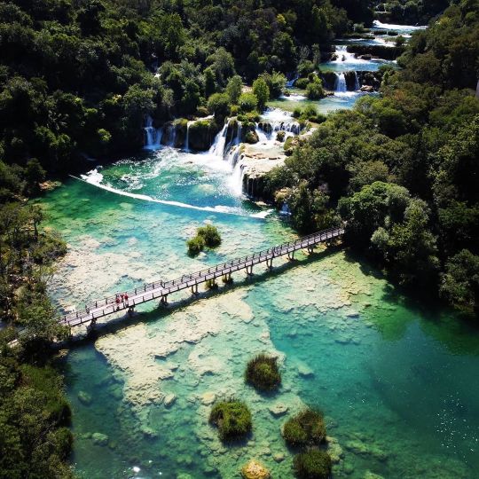
Krka National Park lies within Šibenik-Knin County, and covers a total area of 109 km² of the loveliest sections of the Krka River, and the lower course of the Čikola River. It's a vast and primarily unaltered area of exceptional natural value. The purpose of the park is primarily to serve science, culture, education and recreation, while tourism activities have also been introduced for its visitors. Including the submerged part of the river at the mouth, the Krka River is 72.5 km long, making it the 22nd longest river in Croatia. It springs in the foothills of the Dinara mountain range, 2.5 km northeast of Knin. With its seven waterfalls and a total drop in altitude of 242 m, the Krka is a natural and karst phenomenon. Thanks to @marcelinomauhar for being great company for the day, he's the guy in red swim trunks! 🤣😁🤟 -- #Krka #KrkaNationalPark #KrkaWaterfalls #krkawaterfalls💦 #KrkaWaterfall #KninCroatia #DinaraMountains #DroneGlobe #DroneShot #DronesDaily #Dronestagram #DronePilot #DroneBois #WaterfallsOfInstagram #WaterfallsAreMagic #DontGoChasingWaterfalls #NationalParkGeek #WaterfallMagic #WaterfallChasing #KarstMountains #CascadingWater #CascadingWaterfalls #Cascades #Unesco #UnescoWorldHeritage #WaterIsLife (at Krka National Park UNESCO, Krka - Croatia) https://www.instagram.com/p/CCEAPy4JNY8/?igshid=1tw5ca7l3i3ar
#krka#krkanationalpark#krkawaterfalls#krkawaterfalls💦#krkawaterfall#knincroatia#dinaramountains#droneglobe#droneshot#dronesdaily#dronestagram#dronepilot#dronebois#waterfallsofinstagram#waterfallsaremagic#dontgochasingwaterfalls#nationalparkgeek#waterfallmagic#waterfallchasing#karstmountains#cascadingwater#cascadingwaterfalls#cascades#unesco#unescoworldheritage#waterislife
0 notes
Photo

Limestone karst mountains and the Li River, Yangshuo, Guangxi region of #China. Photo by Chris Raven #photography #travel #landscape #landscapephotography #yangshuo #karstmountains #liriver #river #nature #outside #boats #travelling #travelphotography #natgeo #lonelyplanet (at China) https://www.instagram.com/p/B1alsW2FSVA/?igshid=v9juexkyi16m
#china#photography#travel#landscape#landscapephotography#yangshuo#karstmountains#liriver#river#nature#outside#boats#travelling#travelphotography#natgeo#lonelyplanet
0 notes
Text
Set amidst fields of rice & corn, the iconic red Vietnamese flag dominates the stunning karst landscape at Lung Cu peak that marks Vietnam’s northern boundary with the Yunnan province of China. Untouched by mass tourism with only Home-stays for accommodation, Lung Cu, located in the remote Dong Van district of Ha Giang province, is the northernmost point of Vietnam.
Vietnamese flag sways at our homestay with another one on top of the tower at Lung Cu peak.
Dong Van Karst UNESCO Geopark in North Vietnam covers four northern districts of Quan Ba, Yen Minh, Dong Van, and Meo Vac. Highway QL4 that’s starts from Ha Giang runs across all the four districts and motorbiking through this unique Karst landscape is a perfect way of visiting the Geopark. (Read more: Motorcycle Diaries: The extraordinary Karst landscape of North Vietnam)
#gallery-0-17 { margin: auto; } #gallery-0-17 .gallery-item { float: left; margin-top: 10px; text-align: center; width: 50%; } #gallery-0-17 img { border: 2px solid #cfcfcf; } #gallery-0-17 .gallery-caption { margin-left: 0; } /* see gallery_shortcode() in wp-includes/media.php */
Riding through the unique Karst landscape of Dong Van Karst Unesco Geopark in North Vietnam.
Colorful villages & landscape of Dong Van Karst geopark.
A hearty meal of Pho – a Vietnamese soup noodle, multiple stops for caphe (Vietnamese coffee) and refueling our motorbikes, we had crossed kilometers of breathtaking Karst scenery riding inside Dong Van Geopark through the towns of Quan Ba & Yen Minh before we took the detour from the highway towards Lung Cu, the northernmost village of Vietnam bordering China and home to the Lolo & Hmong ethnic minorities of Vietnam.
Green Karst mountains till your eyes can see
The road to this quaint village passes very close to China border with just a crooked barbed wire separating the two countries at some places. We even parked our bikes and crossed over to the China side and saw a road and a few buildings in the distance. Following pointers of homestays, we rode up to the end of the village and found a homestay with unobstructed views of the peak & the red flag swaying on top of Lung Cu tower.
Red flag at Lung Cu tower that marks the international boundary with China
Our host spoke broken English but with the help of another guest, who helped with the translation, we were able to communicate with each other. He showed us to our rooms and brought us hot green tea as it drizzled outside. Sitting on low bamboo furniture in the balcony sipping on hot green tea with a view of the karst mountains & flag tower floating in the monsoon clouds and cornfields glowing golden in the sunset this was my first time at a homestay in Vietnam, and for a moment the smell of petrichor surrounded by the fields transported me to summer holidays I spent at our village in Himachal, where everyone would gather around the garden in the evening sipping on chai.
#gallery-0-18 { margin: auto; } #gallery-0-18 .gallery-item { float: left; margin-top: 10px; text-align: center; width: 50%; } #gallery-0-18 img { border: 2px solid #cfcfcf; } #gallery-0-18 .gallery-caption { margin-left: 0; } /* see gallery_shortcode() in wp-includes/media.php */
Lolo Home Stay at Lung Cu
Village scenes early morning
Sunset over cornfields at Lung Cu
Walking around the village
Lolos are known for their colorful traditional costumes and the walls had framed pictures of their family dressed in traditional costumes on various occasions that offered a glimpse into their lives. Talking to our host that night over a communal dinner table cheering on shots of corn wine, we got to know that we were probably the first Indians to visit the village and he wanted to find out why we decided to visit Vietnam, “Isn’t it similar to your country?” he asked. To which (I wondered, they haven’t seen the Himalayas!) I said, yeah some parts of North Vietnam may be similar in some way to northeastern India but access to such remote places in India is not easy as mostly they are protected areas that need special permits to visit. Also, I don’t think in such remote locations in India I’d find a working Internet, let alone 4G network that I was getting here, for free! 😉
Sunset at Lung Cu, northernmost point of Vietnam
One of the most unique experiences while traveling, a homestay is the best way to get acquainted with the local way of living and taste local food. I woke up next morning to the sound of a rooster crowing and as I walked around I realized most locals in the village had already done a few rounds of collecting corn back & forth from the fields and were taking a break drinking beer! Soon breakfast was served where everyone sat around a huge communal table and ate bowls of rice, stir-fried chicken & giblets with leafy vegetables, boiled eggs, chicken with broth and a few leftovers from last night’s dinner re-cooked with green herbs. For me, it was a heavy meal for breakfast, but for everyone else who had spent their morning since sunrise working at the cornfields, it was a sumptuous meal. Here I was gulping down each bite with a sip of water while everyone cheered juggling shots of corn wine!
#gallery-0-19 { margin: auto; } #gallery-0-19 .gallery-item { float: left; margin-top: 10px; text-align: center; width: 50%; } #gallery-0-19 img { border: 2px solid #cfcfcf; } #gallery-0-19 .gallery-caption { margin-left: 0; } /* see gallery_shortcode() in wp-includes/media.php */
Cafe Cuc Bac
At Lolo village in Lung Cu
Mostly wild and uninhabited forested green Karst Mountains, peppered with colorful quaint ethnic villages and terraced paddy & cornfields, riding through Dong Van Geopark on the highway is a unique experience especially on a motorbike, and the detours on the route are as rewarding. Usually, Lung Cu is on a day trip itinerary on the way to Dong Van town but I’d recommend staying for a night to get an immersive experience of the place. There is also a café (Cuc Bac) near the homestay where you can enjoy local drinks and chat with locals after a stroll in the village or climbing the stairs up to Lung Cu flag tower.
#gallery-0-20 { margin: auto; } #gallery-0-20 .gallery-item { float: left; margin-top: 10px; text-align: center; width: 50%; } #gallery-0-20 img { border: 2px solid #cfcfcf; } #gallery-0-20 .gallery-caption { margin-left: 0; } /* see gallery_shortcode() in wp-includes/media.php */
Motorbiking through North Vietnam
Ha Giang loop in Dong Van Karst Geopark
It’s advisable to carry a rain jacket/ coat or a poncho as it can rain anytime and even at 1400m it does get cold so carry a warm upper for evenings/ nights. The roads are not in perfect condition but there are no heavy vehicles like trucks on the route which makes for easy riding on the winding mountain slopes as you enjoy the panoramic views. Read more on our travels motorbiking in Vietnam.
*NEW* Motorcycle Diaries: Lung Cu, the north pole of Vietnam Riding to the northernmost point of #Vietnam #biking #adventuretravel Set amidst fields of rice & corn, the iconic red Vietnamese flag dominates the stunning karst landscape at Lung Cu peak that marks Vietnam’s northern boundary with the Yunnan province of China.
#adventuretravel#Asia#biking#dongvan#dongvangeopark#ecofriendly#ethnic#hagiang#Holiday#home-stay#karstmountains#Landscape#Landscape photography#lungcu#Mountain#Nature#nature photography#northvietnam#offbeatvietnam#ontheroad#Photography#Places#roadtrip#sustainable#sustainabletourism#Travel#Travel Photography#travelblog#traveldiary#travelvietnam
1 note
·
View note
Link
Capture the most beautiful mountains and rivers in Yangshuo, Guilin, China.
#yangshuophotographytours#yangshuophototours#china#yangshuoguilin#yangshuochina#asiatravel#photographydestinations#nikon#landscapes#nature#karstmountains#liriver#mercierzeng#guilinphototours
0 notes
Photo

the #20yuanviewpoint 😁 -#biketrip along #liriver #watching #verychinese #tourism #funpeople #nicetrip #bamboobamboo 😁 #karsthills #karstmountains #xingping #china #sabbatinacal (at Laozhai Shan - Mountain in Xingping)
#liriver#bamboobamboo#xingping#nicetrip#verychinese#tourism#sabbatinacal#funpeople#karsthills#20yuanviewpoint#karstmountains#watching#china#biketrip
0 notes
Video
instagram
Cruising through Halong Bay - Floating Village Life! So sad the leave this place - it's been an incredible three days! #halongbay #boatcruise #floatingvillage #karstmountains #heartbelongstohalong #castaways (at Làng Chài Nổi - Cát Bà, Hạ Long)
0 notes
Photo

#REPOST @inspiredquests . Fairy-tale views of China's Karst Mountains along the Li River. . #InspiredQuests | @KevinEssar specialises in #DesigningIncredibleTravelExperiences aboard #luxury #river, #ocean, and #expedition #cruise #ships and #yachts and with the world's best #adventuretravel companies. | www.InspiredQuests.com . Enjoy expert advice and exclusive benefits only from your #Virtuoso luxury #travel advisor. | www.virtuoso.com/advisor/InspiredQuests . Contact me today to schedule a complimentary consultation. | [email protected] . #yeg #yegbusiness #luxurytravel #traveller #traveler #worldtravel #worldtraveller #worldtraveler #adventure #CruiseWithKevinAndBrahm #China #KarstMountains #LiRiver (at Li River) https://www.instagram.com/p/Bun1bQ8hfGr/?utm_source=ig_tumblr_share&igshid=1l8ri7t891w7e
#repost#inspiredquests#designingincredibletravelexperiences#luxury#river#ocean#expedition#cruise#ships#yachts#adventuretravel#virtuoso#travel#yeg#yegbusiness#luxurytravel#traveller#traveler#worldtravel#worldtraveller#worldtraveler#adventure#cruisewithkevinandbrahm#china#karstmountains#liriver
0 notes
Photo


The Guilin Province is perhaps the most notable place to experience the Karst mountain landscape but Huang Hua gave me a glimpse of their unique peaks sprinkled alomost sporadically across the flat fields in Qingyuan.
0 notes
Photo

Ninh Binh im Nebel - #ninhbinh #hangmua #tamcoc #biketrip #exploring #limestones #ricefields #karstmountains #offroad #foggy #mist #beautifulplace #justcruisin #bondingtimewithnewbike #bikepacking #vietnam #sabbiketinacal #sabbatinacal (at Ninh Bình)
#sabbiketinacal#sabbatinacal#karstmountains#mist#tamcoc#limestones#vietnam#hangmua#exploring#biketrip#ricefields#ninhbinh#offroad#bikepacking#justcruisin#beautifulplace#foggy#bondingtimewithnewbike
0 notes
Video
instagram
Gorgeous day to drive around listening to retirement plan on radio... #gorgeousday #winter #mondayfunday #gay #gotmyshadeson #love #beautifulday #life #view #hiking #quite #nofilter #sunshine #chilife #peaceful #chicagoans #weekendoff #selfiesunday #socal #inthecountry #santamonica #somuchsnow #hangingwbff #karstmountains #android #pointedtoes #postmissing #yayforsnow #snow #whatwinter
#gotmyshadeson#postmissing#karstmountains#love#hiking#socal#chilife#selfiesunday#inthecountry#beautifulday#winter#snow#mondayfunday#peaceful#android#chicagoans#life#gay#sunshine#gorgeousday#pointedtoes#quite#somuchsnow#santamonica#hangingwbff#whatwinter#yayforsnow#weekendoff#nofilter#view
0 notes
Last Seen Blogs

bishohealer
My Diary

hotmaleworld
The Hottest Men Of All Shapes, Sizes & Race

the-kipsabian
KIP SABIAN WEMBLEY MOMENT 2K24 💜💜💜

redaznoff
REDA ZN

slm-rp
Strangers Like Me