#ganga and kosi news
Text
Corbett National Park Experiences
I have been to Corbett National Park many times as a group leader, birding guide and naturalist. Taking care of 11 to 16 overseas guests was not easy. They were in a foreign land, and needed extra care and warmth. Which I delivered. I had help from a local birder, and trips were smooth.
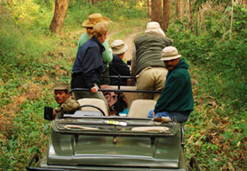
The focus was on birding, but that was not the end since everyone wanted at least on look at the tiger. So I had a double task at hand, and it was need of the hour to succeed. Tigers were hard to come by in those days a decade back, and I was facing a great challenge.
There was one German group very eager to see the striped cat, I remember, and they were pressing me to come up with one.
Corbett tiger landscape is a true heaven with amazing panoramic grandeur of the Himalayan Foothills or Terai as it is known in Hindi. The euphoria sets in as soon as you reach Ram Nagar. This is where our hotel Tiger Camp was situated and we reached there from New Delhi after many fruitful birding stops. I was lucky to see a red necked falcon on that trip for the first time.
Ramnagar is a busy town situated right on the edge of Corbett Tiger Reserve’s buffer zone. This is where at Sunderkhal a man eating tigress had killed a women. And we birded there with great caution moving in groups all along. We stayed a day at Tiger Camp and went bird watching at a few chosen stops like Mohaan, Garjiya Temple, Sitavani, Kosi River Bank, Kumeria and Marchula.
We could sight the Ibis Bill, Little Forktail, Nepal Wren, Long Billed Thrush among many wonderful avian. Our next stop was Dhikala Complex with loads of grasslands, dense forests, Ram Ganga River and the famous crocodile pool. Dhikala Complex is where Jim Corbet Stayed during his tours to kill man eaters. Behind the complex is famous Dhikala Chaur a tall elephant grassland that stretches over 11km. Here you can see wild elephants, hog deer and the tiger from the complex.
The birding experiences were fantastic but the the big cat was missing. On the last day, I requested the group for a tiger stop in between. They all agreed. So as I was moving in one jeep along the Ram Ganga River I heard an alarm call on top of the hillock next to us. “Stop!”

The perplexed driver did as he was told. The alarm cry was that of the Sambar Deer, least to be frightened by other animals except the big cats. As we stopped, I saw a herd of spotted deer scampering along in the opposite direction across the river and vanish into the dense canopy.
That’s It ! I told the driver not to move an inch, and requested the guests to sit absolutely still without making any noise. By this time all the five jeeps had rolled down, and I told the drivers not to move and stay quiet.
And then nothing happened for a long time. I could see frustration creeping in. We had waited for over 45 minutes the forest was quite as usual. Am I going to lose my job? “What are we waiting for? A guest asked me as politely as he could.
“The tiger,” I whispered losing confidence, but I was sure the striped cat was in between us and the river bank hidden in dense canopy under a tree perhaps. I was taking a risk as I was wasting precious birding time. The guest sat quiet but perplexed, and the drivers were getting impatient. Worst, there were no birds around. Everything was still and quiet. Anyway, I stuck to my order, and the impatient drivers obeyed.
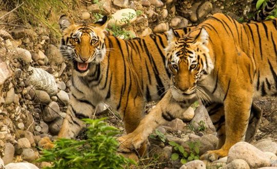
After what seemed an eternity, we saw a troupe of rhesus macaques heading towards us. Eager as usual, I signaled the guests to get the camera ready. I knew that the monkeys will head straight toward the tiger or the leopard whatever was hiding near us. It happened, and to my relief irritated by raucous alarm cries the tiger came out. It was walking parallel to us. The sight was mesmerizing, and the guests forgot to shoot (camera). Anyway on our last tiger trip the big cat had been sighted. The guests were stunned, and I was their hero till the end of the birding safari. Elated I asked the team to head straight to the rest house but drive slowly. We saw another tiger near the rest house as I had predicted a day earlier. This time one guest could photograph the tiger with its head hidden behind a tree. ha!
undefined
youtube
1 note
·
View note
Text
Bihar Floods: बिहार के 14 जिलों में बाढ़ से तबाही, तस्वीरों को देखकर थर्रा जाएंगे
Bihar Floods: बिहार के 14 जिलों में बाढ़ से तबाही, तस्वीरों को देखकर थर्रा जाएंगे
[ad_1]
नवभारतटाइम्स.कॉम | Updated: 31 Jul 2020, 12:08:24 PM IST
बिहार के 14 जिलों की 39,63,728 आबादी बाढ़ से प्रभावित है और इसमें से 3,16,661 लोगों को अबतक सुरक्षित ठिकानों तक पहुंचाया गया है । आपदा प्रबंधन विभाग से बृहस्पतिवार को प्राप्त जानकारी के मुताबिक प्रदेश के 14 जिलों – सीतामढ़ी, शिवहर, सुपौल, किशनगंज, दरभंगा, मुजफ्फरपुर, गोपालगंज, पूर्वी चम्पारण, पश्चिम चंपारण, खगडिया, सारण, समस्तीपुर,…
View On WordPress
#Bihar Flood 2020#Bihar floods#bihar floods latest news#bihar floods update news#bihar-assam flood news updates#floods in Bihar#ganga and kosi news#Water Deluge In Bihar#बिहार बाढ़#बिहार मे बाढ़
0 notes
Text
बिहार बाढ़: पटना को राहत तो मुंगेर से लेकर भागलपुर तक चढ़ी गंगा, लाल निशान से नीचे आई कोसी, जानें दूसरी नदियों का हाल
बिहार बाढ़: पटना को राहत तो मुंगेर से लेकर भागलपुर तक चढ़ी गंगा, लाल निशान से नीचे आई कोसी, जानें दूसरी नदियों का हाल
बिहार में वर्षा का सिलसिला पिछले एक सप्ताह से लगातार जारी है। लिहाजा नदियों में तेजी से उतार-चढ़ाव हो रहा है। गंगा पटना में जिस रफ्तार बढ़ी उसी रफ्तार से नीचे भी आने लगी। लेकिन यह नदी हाथीदह से लेकर…
Source link

View On WordPress
#Adhwara river#Bagmati river#Bihar flood latest news#bihar flood latest updates#Bihar flood latest updates news#Bihar flood news#Bihar floods#budhi gandak river#danger mark#Discharge#Gandak river#Ganga River#Ghaghra river#ghat#Hindi News#Hindustan#Kamala river#Khari river#Kosi River#News in Hindi#Rain#Rivers#ups and downs#waters#अधवारा नदी#उतार चढ़ाव#कमला नदी#कोसी नदी#खतरे का निशान#खिराी नदी
0 notes
Text
Bihar: Floodwaters enter new areas, hit million more

PATNA: Floodwaters spread to new areas in the 11 affected districts of Bihar, hitting one million more population, even though no fresh death was reported and the toll remained at 10, the Disaster Management Department said on Monday.
The latest bulletin, said a total of 24.42 lakh people have been hit by floods in 765 panchayats of 93 blocks of 11 districts with Darbhanga being the worst-hit, where 8.87 lakh people have been displaced in its 14 blocks.
The Sunday bulletin had said the number of flood- hit population in Bihar was nearly 15 lakh in 11 districts.
Apart from Darbhanga, East Champaran and Muzaffarpur districts are badly affected where 7.0 lakh and 3.20 lakh people have been impacted, the bulletin said.
The air-dropping operation of food packets by Indian Air Force helicopters has been stopped from this evening in Gopalganj, Darbhanga and East Champaran districts.
The operation had started in these places on July 25.
A senior officer of the Disaster Management department said the relief distribution through boats and other means would continue in these places as also in other marooned districts.
Each relief packet contains two-and-a-half kg of flattened rice, one kg gram, half kg jaggery, matchbox and a packet of candles which were being prepared at Sri Krishna Memorial Hall in the state capital.
People have been forced to leave their homes due to rampaging flood. The situation seems to be more or less same in every affected district.
A family in Kaharpur village of Naugachhia sub-division of Bhagalpur district was seen demolishing their home as Kosi river was about to take it in its stride.
Asked the reason for doing so, they said that several houses have been washed away in the Kosi water and his house will also be taken away in a few hours so he is removing bricks to use them for another house once the situation improves.
In Shormar village of Samastipur where floodwaters have submerged everything, one of the affected people said a vast area has been flooded. Even the school has been badly affected. He said that people don’t have water to drink.
It seems that people will have to drink the floodwater after boiling them, he said, adding no help from the administration has reached to them so far.
In Baliadangi village of Kishanganj district, people have been surrounded by floodwaters and there is no means to get them out of the place.
The total number of casualties stood at 10 in districts with no fresh fatality reported on Monday, the bulletin said.
The flood affected districts are Sitamarhi, Sheohar, Supaul, Kishanganj, Darbhanga, Muzaffarpur, Gopalganj, West Champaran, East Champaran, Khagaria and Saran.
Seventeen teams of the NDRF and eight of the SDRF are involved in the rescue operations as part of which 1.67 people have been evacuated from the affected areas so far, the bulletin said.
Besides, 12,858 people are staying in 29 relief camps while nearly 3.28 lakh people were being fed at 703 community kitchens.
National Disaster Response Force (NDRF) Commandant Vijay Sinha said his personnel have so far evacuated 6600 affected people and cattle to safer places in Gopalganj, Saran, East Champaran, West Champaran, Darbhanga and Supaul.
Besides, the NDRF has also been helping the district administration in distributing relief materials, Sinha said, adding teams have helped medical personnel reach affected rural areas.
The flood relief work has been quite a challenge this year in view of the raging COVID-19 pandemic, he said.
Several rivers such as Baghmati, Burhi Gandak, Kamlabalan, Lalbakeya, Adhwara, Khiroi, and Ghaghra are flowing above danger level while the water level of Ganga is increasing at Hathidah, Munger, Bhagalpur, and Kahalgaon. Though the level has gone down at Gandhi ghat in Patna, it has remained steady at Buxar and Digha in Patna, a Water Resources Departments bulletin said.
Meanwhile, Chief Public Relation Officer (CPRO), of East Central Railway zone, Rajesh Kumar, said some trains in the Darbhanga-Samastipur section have been diverted due to floodwaters coming up to the girder of Railway bridge in between south Hayaghat and Thalwara.
The post Bihar: Floodwaters enter new areas, hit million more appeared first on BBC BREAKING NEWS.
from WordPress https://bbcbreakingnews.com/bihar-floodwaters-enter-new-areas-hit-million-more/
0 notes
Text
Flood increase problems in many states, UN came forward to help
Flood increase problems in many states, UN came forward to help
Due to heavy rains in many states of India, many rivers are in spate, due to which flood situation has been created. People are suffering from floods. In many districts of Bihar, Uttar Pradesh, Assam, flood waters have caused havoc. In Bihar, 11 people were reported drowned in the flood waters, while in Ghaghra and Sharda rivers of Uttar Pradesh, about 40 villages were submerged due to the spill.…
View On WordPress
#death in flood#Flood#Flood in asam#flood in Assam#Flood in Bihar#Flood in india#Flood in UP#flood news#Flood News updates#flood Trouble#flood victims#Ganga#Ghagra River#India Flood News#Kosi River#national news#News of the flood#Sharda River#United Nations#water lavel increase in UP
0 notes
Text
NCERT Class 12 History Chapter 12 Colonial Cities Urbanisation, Planning and Architecture
NCERT Class 12 History Solutions
Chapter 12 Colonial Cities Urbanisation, Planning and Architecture
NCERT TEXTBOOK QUESTIONS SOLVED :
Q 1. To what extent are census data useful in reconstructing patterns of urbanisation in the colonial context? (or)
“A careful study of census reveals some fascinating trends of urbanisation in 19th century.” Support the statement with facts.
Ans. A careful study of the data collected through the census provides us a lot of information in understanding the trend of urbanisation. It can be examined as under:
(a) The process of urbanisation was sluggish in India after 1800.
(b) In the nineteenth century and in first two decades of the twentieth century the proportion of the urban population was very low and stagnant.
(c) Which recorded between 1900 and 1940, A 13% increase in the urban population which recorded between whereas during the same period, these was a overall 10% increase in the population of the whole country.
(d) The data, thus, collected helps us in the enumeration of people according to their age, sex, caste, religion, occupation, etc.
Q 2. What do the terms “White” and “Black” Town signify?
Ans. The British had white skin as they were often described ‘white’ and they considered themselves as superior to others. On the other hand, the blacks had brown or black skin. So they were known as the ‘black’. The White signified their superiority over the black due to the colour of their skin. The British symbolised the Black areas full of chaos and anarchy, filth and disease and on the other hand, the white areas stood for cleanliness and hygiene. In Black areas, epidemics like cholera and plague often broke out. So the British took stringent measures to ensure sanitation and public health to prevent diseases of the Black areas. They ensured underground piped water supply and introduced sewerage and drainage system in White areas. Thus, we can say, the White Towns were those parts of the colonial towns where the White people lived. These towns had wide roads, barracks, churches, paradeground, big bungalows and gardens, symbolised settled city life, whereas the Indian lived in Black Towns, were said to be unorganised and a source of filth and disease.
Q 3. How did prominent Indian merchants establish themselves in the colonial city?
Ans. The prominent Indian merchants and traders settled in colonial cities like Bombay, Calcutta and Madras. They served as agents or middlemen for the British and lived traditionally built courtyard houses in the Black Town. They centred over large tracts of land in these cities and heavily made investments for the future. They wanted to impress their British masters or colonial ruler or white people living in white towns by giving lavish parties during festivals seasons and built temples to establish their supremacy and prestige in society.
Q 4. Examine how concerns of defence and health gave shape to Calcutta.
Ans. Sirajudaula, the Nawab of Bengal in 1756, sacked the small fort from Britisher. In this fort the British traders had built to house their goods. Consequently, when Sirajudaula was defeated in the Battle of Plassey, the British built a new fort, Fort William which could not be easily attacked. Around this a vast open space was left. This open space ‘ was called the Maidan or garermath. This was done for security reasons, because there would be no obstructions to a straight time of fire from the Fort against an advancing enemy army. Soon the British began to move out of the Fort. They built residences along the periphery of the Maidan. This indicates that how the English Settlement in Calcutta began to take shape. The vast open space around the Fort William became the significant town planning measure in Calcutta (Now Kolkata).
Lord Wellesley was more concerned about the conditions that existed in the cities. Cities were overcrowded, and had no sanitation facilities. He issued an administrative order in 1803 on the need for town planning and set up various committees for this purpose open places in the city would make the city healthier. As a result of this, many bazaars, ghats, burial ground and tanneries were cleared or removed. After Wellesley’s departure, the Lottery Committee carried on with the work of town planning in Calcutta.
Q 5. What are the different colonial architectural styles which can be seen in Bombay city?
Ans. In the past, buildings were at odds with the traditional Indian buildings. Gradually, Indians too got used to European architecture and made it their own. The British in turn adapted some Indian styles to suit their needs. One example is the bungalow which was used by government officers in Bombay. The colonial bungalow was set on extensive grounds which ensured privacy. The traditional pitched roof and surrounding veranda kept the bungalow cool in summer months. These bungalows can still be seen in the city. Other than that traditional styles of decoration and building exist. The lack of space in the city and crowding led to a type of building unique to Bombay, the chawl.
Q 6. How were urban centres transformed during the eighteenth century?
Ans. (i) The disintegration of the mughal empire after the death of Aurangzab paved the way of emergence of paverful regional powers. The capital cities of these regional kingdom likes Lucknow, Poona, Nagpur and Barda now become important. Taking the advantage of this opportunity many nobles and officials created new urban settlements such as the qasbah and ganj.
(ii) The European companies too had set up their bases in different parts of India during the sixteenth and seventeenth centuries. For example the Portugues (in Panaji in 1570) and the British in Madras in 1639. With the expansion in commercial activity, towns began to emerge as trading centres.
(iii) From the mid-eighteenth century trading. Centres like Surat and Dhakha which had grown in the seventeenth century now began to decline as trade shifted to other places. When the British acquired Bengal and the east Indian’s Company’s trade hereafter expanded the colonial port cities likes Madras and Calcutta. These new part cities began to emerge as the new economic capitals.
(iv) In these newly developed cities many new buildings were built and new occupations developed. People flocked to these cities in large numbers. By the nineteenth century these newly developed cities become the biggest cities in India.
Q 7. What were the new kinds of public places that emerged in the colonial city? What functions did they serve?
Ans. The Indians found the new colonial cities as bewildering. They were surpassed the new transport facilities available here. The means of transport facilities which included horse- drawn carnages, tram11 and buses. Enabled the people to live at far away places from the city centre. Now they lived at some other places and served at some other places.
Emergence of new public places: The new colonial cities far away place witnessed new public places such as the theatres, cinema-halls, gardens, public parks, etc. Besides these were clubs and Garden Houses.
Functions: These newly created public places were very exciting. They were an important source of entertainment and helped increasing social interaction. The people were able to express their opinions on society and government. They could also question the practice of social customs.
Q 8. What were the concerns that influenced town planning in the nineteenth century?
Ans. (i) Two concerns which influenced the town planning in the nineteenth century were defence and health.
(ii) In many towns British built forts to protect their factories. Around the fort a vast open space was left open. This vast space was known as the Maidan.
(iii) It was done so that there would be no obstructions to a straight line of fire from the Fort against an advancing enemy.
(iv) Attempts were also made to improve the sanitation and cleanliness by creating open spaces in the city.
(v) For this purpose, in Calcutta many bazaars, ghats and burial grounds were cleared.
Q 9.To what extent were social relations transformed in the new cities?
Ans. (i) There was a big contrast between extreme wealth and poverty in the new cities. New means of transport facilities such as horse-drawn carriages, trams, buses, etc. made travelling from home to work an interesting experience.
(ii) Creation of public places like theatres public parks and cinema halls provided new forms of entertainment and social interaction.
(iii) New social groups were formed people of all classes started to migrate to the cities. With an increased demand for lawyers and engineers the “middle class” increased. Debate and dicussion became popular and established social norms and practices were questioned.
(iv) Cities also offered new opportunities for women. They chose new professions in the city as factory workers, teachers, film actresses, etc. for a long time so women remained objects of social censure.
Q 10. On an outline map of India, trace the major rivers and hill ranges. Plot ten cities mentioned in the chapter, including Bombay, Calcutta and Madras, and prepare a brief note on why the importance of any two cities that you have marked (one colonial and one pre-colonial) changed in the nineteenth century.
Ans. Rivers are Ravi, Satluj, Ganga, Yamuna, Beas, Kosi, Narmada, Godavari, Krishana, and Kaveri.
Major Hill ranges are the Himalayas, Aravali, Vindhyachal, Satpura, Karakoram.
from Blogger http://www.margdarsan.com/2020/08/ncert-class-12-history-chapter-12.html
0 notes
Link
via Today Bharat nbsp; The flood situation in Bihar continues to remain grim, as the death toll has risen to 80. The rivers Ganga, Sone, Punpun, Adhwara, Kosi, Mahananda and Parman rivers are still in spate and are flowing above the danger mark at most of the places. Meanwhile, water has receded in the river Punpun in Patna district, while the situation has relatively improved in some localities, Rajendranagar area of the city still remains inundated. Over 22 lakh people across 14 districts are affected due to floods. 25 teams of NDRF and SDRF are conducting rescue and relief operations. As many as 366 community kitchens are being run by the government to provide cooked meal to the flood affected people. To make the matters worse, there is an outbreak in the cases of Dengue, Chikengunea and Malaria. Around 775 cases of dengue have been identified in Patna Medical College and Hospital. 170 fresh cases of dengue have been registered in Patna hospital in the last 24 hours. The state government has also made arrangements to treat dengue patients with a separate ward for the treatment. A six member central team visited Bihar to assess the damage caused by flood and water logging. The team was led by G. Ramesh Kumar, Joint Secretary in the Ministry of Home Affairs.
0 notes
Text
Bihar Flood: 'मेरे विकास को बाढ़ का श्राप लग गया सरकार'... एक ब्रेड से पल रहा पेट!
Bihar Flood: ‘मेरे विकास को बाढ़ का श्राप लग गया सरकार’… एक ब्रेड से पल रहा पेट!
[ad_1]
बिहार में बाढ़ ���े हालात बद से बदतर होते जा रहे हैं। इस बाढ़ में सबसे बुरी हालत पूर्वी चंपारण की है जिसकी करीब 7 लाख आबादी प्रभावित हुई है। पूरे बिहार की बात करें तो राज्य के 12 जिलों की करीब 30 लाख की आबादी प्रभावित हो चुकी है।
नवभारतटाइम्स.कॉम | Updated: 29 Jul 2020, 04:08:46 PM IST
पूर्वी चंपारण/ सारण/ गोपालगंज/ मुंगेर:
बिहार में बाढ़ लगातार कहर बरपा रही है। उत्तर बिहार में बाढ़ की…
View On WordPress
#Bihar Flood 2020#Bihar floods#bihar floods latest news#bihar floods update news#bihar-assam flood news updates#flood updates#gandak river rises#ganga and kosi news#बिहार बाढ़#बिहार मे बाढ़
0 notes
Text
250 साल पुराना जमींदारी बांध आज भी 'बाहुबली', लेकिन क्यों धराशायी हो जा रहे करोड़ खर्च कर बने तटबंध... जानिए चौंकानेवाले तथ्य
250 साल पुराना जमींदारी बांध आज भी ‘बाहुबली’, लेकिन क्यों धराशायी हो जा रहे करोड़ खर्च कर बने तटबंध… जानिए चौंकानेवाले तथ्य
[ad_1]
हाल में पूर्वी चंपारण, पश्चिमी चंपारण, गोपालगंज समेत कई जगहों पर बांध टूटने की खबर आई है। अक्सर लोगों के जेहन में ये सवाल उभरता है कि सदियों पुराने जमींदारी बांध आज तक टिके हुए हैं लेकिन करोड़ों खर्च करने के बाद भी नए तटबंध क्यों टूट जाते हैं। जवाब के लिए देखिए हमारी ये रिपोर्ट
Edited By Hrishikesh Singh | नवभारतटाइम्स.कॉम | Updated: 28 Jul 2020, 05:02:00 PM IST
भोजपुर में 250 साल…
View On WordPress
#bihar embankment#Bihar Flood 2020#Bihar floods#bihar floods latest news#bihar-assam flood news updates#flood updates#gandak river rises#ganga and kosi news#zamindari bandh#बिहार बाढ़
0 notes
Text
Bihar Flood News Update: महिला ने NDRF की रेस्क्यू बोट पर दिया बच्ची को जन्म
Bihar Flood News Update: महिला ने NDRF की रेस्क्यू बोट पर दिया बच्ची को जन्म
[ad_1]
Edited By Sudhendra Singh | नवभारतटाइम्स.कॉम | Updated: 26 Jul 2020, 05:05:00 PM IST
एनडीआरएफ की बोट पर नवजात बच्ची हाइलाइट्स
एनडीआरएफ की रेस्क्यू बोट पर महिला ने दिया एक बच्ची को जन्म।
घटना बाढ़ग्रस्त बिहार के पूर्वी चंपारण जिले की है।
मां और बच्ची दोनों की हालत स्थिर बताई जा रही है।
NDRF की टीम ने मां-बच्ची को प्राथमिक स्वास्थ्य केंद्र में भर्ती करा दिया है।
पूर्वी चंपारण
बिहार में…
View On WordPress
#Bihar Flood 2020#Bihar floods#bihar floods latest news#birth to a baby girl on a rescue boat#Flood in Bihar#flood-hit east champaran#gandak river rises#ganga and kosi news#NDRF#बिहार बाढ़
0 notes
Text
Bihar Flood Updates: कहीं पानी से घिरे घर में बच्चे लगा रहे गुहार तो कहीं अन्नदाताओं की मेहनत निगल रहा बाढ़
Bihar Flood Updates: कहीं पानी से घिरे घर में बच्चे लगा रहे गुहार तो कहीं अन्नदाताओं की मेहनत निगल रहा बाढ़

[ad_1]
बिहार में बाढ़ ने बेहद ही डरावनी शक्ल अख्तियार कर ली है। 12 जिले बाढ़ की विनाशलीला का सामना कर रहे हैं। NDRF और SDRF दोनों की ही टीमें लगातार रेस्क्यू ऑपरेशन कर रही हैं। पश्चिमी चंपारण, पूर्वी चंपारण, सीतामढ़ी, शिवहर, सुपौल, किशनगंज, दरभंगा, मुजफ्फरपुर, गोपालगंज और खगड़िया में बाढ़ के पानी ने कोहराम मचा रखा है। नदियों में गंगा, गंडक, बूढ़ी गंडक, बागमती और कोसी खतरे के निशान के पार जा चुकी…
View On WordPress
#Bihar Flood 2020#Bihar floods#bihar floods latest news#bihar floods update news#bihar-assam flood news updates#flood updates#gandak river rises#ganga and kosi news#बिहार बाढ़#बिहार मे बाढ़
0 notes
Text
बिहार में बाढ़ से त्राहिमाम: आपके लिए ये एक तस्वीर होगी, इनके लिए हर साल का श्राप है ये
बिहार में बाढ़ से त्राहिमाम: आपके लिए ये एक तस्वीर होगी, इनके लिए हर साल का श्राप है ये
[ad_1]
नवभारतटाइम्स.कॉम | Updated: 27 Jul 2020, 06:05:29 PM IST
बिहार में बाढ़ (Bihar Flood) का कहर थमने का नाम नहीं ले रहा है। अब तक सूबे के 11 जिलों में ‘जल सैलाब’ का तांडव देखने को मिल रहा है। बाढ़ की वजह से करीब 15 लाख की आबादी प्रभावित हुई है। अभी भी राज्य की प्रमुख नदियों में उफान जारी है। कई जगह पर ये खतरे के निशान से ऊपर बह रही हैं। सूबे में हालात क्या हैं ये आप मोतीहारी की इस तस्वीर…
View On WordPress
#Bihar Flood 2020#bihar flood bridge collapse#bihar flood latest update#bihar flood news updates#Bihar floods#bihar floods update news#gandak river rises#ganga kosi news
0 notes
Text
NCERT Class 12 History Chapter 12 Colonial Cities Urbanisation, Planning and Architecture
NCERT Class 12 History Solutions
Chapter 12 Colonial Cities Urbanisation, Planning and Architecture
NCERT TEXTBOOK QUESTIONS SOLVED :
Q 1. To what extent are census data useful in reconstructing patterns of urbanisation in the colonial context? (or)
“A careful study of census reveals some fascinating trends of urbanisation in 19th century.” Support the statement with facts.
Ans. A careful study of the data collected through the census provides us a lot of information in understanding the trend of urbanisation. It can be examined as under:
(a) The process of urbanisation was sluggish in India after 1800.
(b) In the nineteenth century and in first two decades of the twentieth century the proportion of the urban population was very low and stagnant.
(c) Which recorded between 1900 and 1940, A 13% increase in the urban population which recorded between whereas during the same period, these was a overall 10% increase in the population of the whole country.
(d) The data, thus, collected helps us in the enumeration of people according to their age, sex, caste, religion, occupation, etc.
Q 2. What do the terms “White” and “Black” Town signify?
Ans. The British had white skin as they were often described ‘white’ and they considered themselves as superior to others. On the other hand, the blacks had brown or black skin. So they were known as the ‘black’. The White signified their superiority over the black due to the colour of their skin. The British symbolised the Black areas full of chaos and anarchy, filth and disease and on the other hand, the white areas stood for cleanliness and hygiene. In Black areas, epidemics like cholera and plague often broke out. So the British took stringent measures to ensure sanitation and public health to prevent diseases of the Black areas. They ensured underground piped water supply and introduced sewerage and drainage system in White areas. Thus, we can say, the White Towns were those parts of the colonial towns where the White people lived. These towns had wide roads, barracks, churches, paradeground, big bungalows and gardens, symbolised settled city life, whereas the Indian lived in Black Towns, were said to be unorganised and a source of filth and disease.
Q 3. How did prominent Indian merchants establish themselves in the colonial city?
Ans. The prominent Indian merchants and traders settled in colonial cities like Bombay, Calcutta and Madras. They served as agents or middlemen for the British and lived traditionally built courtyard houses in the Black Town. They centred over large tracts of land in these cities and heavily made investments for the future. They wanted to impress their British masters or colonial ruler or white people living in white towns by giving lavish parties during festivals seasons and built temples to establish their supremacy and prestige in society.
Q 4. Examine how concerns of defence and health gave shape to Calcutta.
Ans. Sirajudaula, the Nawab of Bengal in 1756, sacked the small fort from Britisher. In this fort the British traders had built to house their goods. Consequently, when Sirajudaula was defeated in the Battle of Plassey, the British built a new fort, Fort William which could not be easily attacked. Around this a vast open space was left. This open space ‘ was called the Maidan or garermath. This was done for security reasons, because there would be no obstructions to a straight time of fire from the Fort against an advancing enemy army. Soon the British began to move out of the Fort. They built residences along the periphery of the Maidan. This indicates that how the English Settlement in Calcutta began to take shape. The vast open space around the Fort William became the significant town planning measure in Calcutta (Now Kolkata).
Lord Wellesley was more concerned about the conditions that existed in the cities. Cities were overcrowded, and had no sanitation facilities. He issued an administrative order in 1803 on the need for town planning and set up various committees for this purpose open places in the city would make the city healthier. As a result of this, many bazaars, ghats, burial ground and tanneries were cleared or removed. After Wellesley’s departure, the Lottery Committee carried on with the work of town planning in Calcutta.
Q 5. What are the different colonial architectural styles which can be seen in Bombay city?
Ans. In the past, buildings were at odds with the traditional Indian buildings. Gradually, Indians too got used to European architecture and made it their own. The British in turn adapted some Indian styles to suit their needs. One example is the bungalow which was used by government officers in Bombay. The colonial bungalow was set on extensive grounds which ensured privacy. The traditional pitched roof and surrounding veranda kept the bungalow cool in summer months. These bungalows can still be seen in the city. Other than that traditional styles of decoration and building exist. The lack of space in the city and crowding led to a type of building unique to Bombay, the chawl.
Q 6. How were urban centres transformed during the eighteenth century?
Ans. (i) The disintegration of the mughal empire after the death of Aurangzab paved the way of emergence of paverful regional powers. The capital cities of these regional kingdom likes Lucknow, Poona, Nagpur and Barda now become important. Taking the advantage of this opportunity many nobles and officials created new urban settlements such as the qasbah and ganj.
(ii) The European companies too had set up their bases in different parts of India during the sixteenth and seventeenth centuries. For example the Portugues (in Panaji in 1570) and the British in Madras in 1639. With the expansion in commercial activity, towns began to emerge as trading centres.
(iii) From the mid-eighteenth century trading. Centres like Surat and Dhakha which had grown in the seventeenth century now began to decline as trade shifted to other places. When the British acquired Bengal and the east Indian’s Company’s trade hereafter expanded the colonial port cities likes Madras and Calcutta. These new part cities began to emerge as the new economic capitals.
(iv) In these newly developed cities many new buildings were built and new occupations developed. People flocked to these cities in large numbers. By the nineteenth century these newly developed cities become the biggest cities in India.
Q 7. What were the new kinds of public places that emerged in the colonial city? What functions did they serve?
Ans. The Indians found the new colonial cities as bewildering. They were surpassed the new transport facilities available here. The means of transport facilities which included horse- drawn carnages, tram11 and buses. Enabled the people to live at far away places from the city centre. Now they lived at some other places and served at some other places.
Emergence of new public places: The new colonial cities far away place witnessed new public places such as the theatres, cinema-halls, gardens, public parks, etc. Besides these were clubs and Garden Houses.
Functions: These newly created public places were very exciting. They were an important source of entertainment and helped increasing social interaction. The people were able to express their opinions on society and government. They could also question the practice of social customs.
Q 8. What were the concerns that influenced town planning in the nineteenth century?
Ans. (i) Two concerns which influenced the town planning in the nineteenth century were defence and health.
(ii) In many towns British built forts to protect their factories. Around the fort a vast open space was left open. This vast space was known as the Maidan.
(iii) It was done so that there would be no obstructions to a straight line of fire from the Fort against an advancing enemy.
(iv) Attempts were also made to improve the sanitation and cleanliness by creating open spaces in the city.
(v) For this purpose, in Calcutta many bazaars, ghats and burial grounds were cleared.
Q 9.To what extent were social relations transformed in the new cities?
Ans. (i) There was a big contrast between extreme wealth and poverty in the new cities. New means of transport facilities such as horse-drawn carriages, trams, buses, etc. made travelling from home to work an interesting experience.
(ii) Creation of public places like theatres public parks and cinema halls provided new forms of entertainment and social interaction.
(iii) New social groups were formed people of all classes started to migrate to the cities. With an increased demand for lawyers and engineers the “middle class” increased. Debate and dicussion became popular and established social norms and practices were questioned.
(iv) Cities also offered new opportunities for women. They chose new professions in the city as factory workers, teachers, film actresses, etc. for a long time so women remained objects of social censure.
Q 10. On an outline map of India, trace the major rivers and hill ranges. Plot ten cities mentioned in the chapter, including Bombay, Calcutta and Madras, and prepare a brief note on why the importance of any two cities that you have marked (one colonial and one pre-colonial) changed in the nineteenth century.
Ans. Rivers are Ravi, Satluj, Ganga, Yamuna, Beas, Kosi, Narmada, Godavari, Krishana, and Kaveri.
Major Hill ranges are the Himalayas, Aravali, Vindhyachal, Satpura, Karakoram.
via Blogger https://ift.tt/3fS3jEf
0 notes
Last Seen Blogs

hallowedmaiden-blog
Untitled

bcnvolio
semper fidelis

halleyd1u2h-blog
Untitled

tomeiame
Tomeiame

halgsayr
هند القصيِّر