#dubaimetroroutemap
Text
Dubai Metro Map 2023
The Dubai Metro's green line debuted on September 9, 2011, following the red line's launch on September 9, 2009. Some of the stations took a while to open. On the other hand, as of March 1, 2014, every station on the green and red lines was fully operational, and as of 2021, the Expo 2020 extension was likewise fully operational.
In order to expand on the 18 green line stations and the 35 red line stations that are currently in operation, both the green and red lines will probably be extended further in the future. All these details are included in Dubai Metro Map 2023 that we will share here. Other lines might open in the future as well.
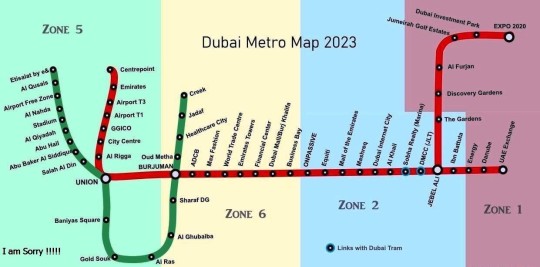
Dubai Metro Map 2023
There are presently 4 zones that make up the Dubai Metro, as you can see from the zone map. Other public transportation options, such as buses and trams, are covered in a total of seven zones. The amount you pay for the trip depends on how many zones you pass through. One-day passes and other tickets covering all zones are available.
For further details on the fares that apply, visit the Dubai Metro Tickets website. Though they still represent excellent value, fares went up when the Tram launched in November 2014. Using the data we have collected on the Dubai Metro stations, the zones, and the current information about open stations, we have developed this Dubai Metro Map 2023 as under.
Dubai Metro Red Line
The Dubai Metro Red Line travels up to UAE Exchange from Rashidiya. This route is approximately 52.1 kilometers long overall, of which 5 kilometers are subterranean. Beginning in 2005, the Red Line's construction was finished by the end of 2009.
This project featured 29 stations and cost about 7.6 billion US dollars (including Green Line). This indicates that the line will cost roughly 102.2 million US dollars per kilometer on average. This line has an average speed of roughly 47 km/h, and the entire trip should take about 70 minutes.
Dubai Metro Green Line
With a total of twenty operational stations, the Dubai Metro Green Line links Etisalat and Creek. This line is measured to be 22.5 kilometers long overall, 8 kilometers of which are subterranean. This line's construction was supposed to be completed in 2006, however owing to a global recession, it was not completed by then. Due to delays, this line was formally inaugurated in September 2011 instead of the scheduled completion date of March 2010.
As was previously indicated, this line was built alongside the Red Line at a cost of roughly 7.6 billion US dollars, or 28 billion AED. The price per kilometer was approximately 102.2 million. It accelerates at an average speed of roughly 38 km/h and takes 40 minutes to reach its destination.
Wrapping Up:
The whole path of the Dubai Metro's Red Line, Green Line, and Tram Line is displayed on the map. It also depicts the stations that Metro Trains travel through across Dubai.
You may learn everything there is to know about the Dubai Metro, including its map, names of metro stations, operating hours, ticket prices, and passenger amenities, by using the information above.
0 notes
Text
Dubai Metro Map
Dubai Metro Map provides Metro Station Names, Red Line & Green Line Metro Route and Interchanging Stations at https://dubaimetromapguide.com/. You can visit this website to see Dubai Metro Schematic Map, Interactive Map, Metro Timings, Facilities for Passengers and Ticket Fares.

1 note
·
View note
Last Seen Blogs

professionalhomecares
Best Home Care Services In Chennai | Professional Home Care

fae-noir
pretty little head

positive-pessimistic-emo
Ho(p)eless Romantic
positive-pessimistic-emo
Ho(p)eless Romantic

irrigationinmelbourne
Untitled