#cyprinodon salinus
Explore tagged Tumblr posts
Text
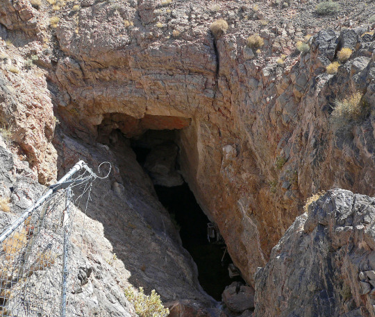
The species found in California is the Death Valley Pup Fish (C. salinus.) This particular habitat and species is Cyprinodon diabolis (so sick 😈) found in my home state of Nevada! ☺️ The Devils Hole is found in Nevada's part of Death Valley, in Nye County! (So like Central and the tippy top of Southern Nevada around the Pahrump area.)
i hope they find a stupid tiny fish or something on mars and make mining illegal, just like the devil’s hole in california


these endangered bastards and their bathtub-sized habitat (just the surface shelf of a giant cave structure thanks) singlehandedly pissed off SO many businessmen lol
189K notes
·
View notes
Photo

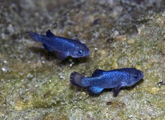
Death valley pupfish (Cyprinodon salinus)
Photo by Ron Wolf
#death valley pupfish#cyprinodon salinus#cyprinodon#cyprinodontinae#cyprinodontidae#cyprinodontoidei#cyprinodontiformes#carangimopharia#perciformes#eupercaria#percomorpha#acanthomorpha#neoteleostei#euteleostei#teleostei#neopterygii#actinopterygii#osteichthyes#vertebrata#chordata
32 notes
·
View notes
Text
An extension of freshwater fish native to North America (specifically the US)

Sacramento pikeminnow | Ptychocheilus grandis

Death valley pupfish | Cyprinodon salinus
(not actually freshwater, as they can survive saline levels 4 times higher than the ocean. I just think they're interesting)

Rosyface shiner | Notropis rubellus


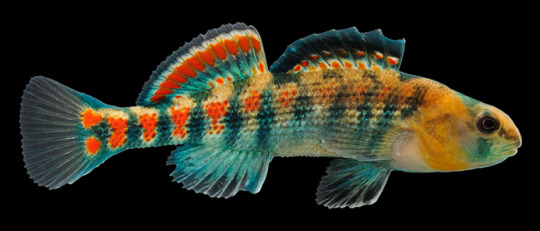
Orangethroat darter (male and female) | Etheostoma spectabile

Johnny darter | Etheostoma nigrum
Photo credit: x, x, x, x, x
73 notes
·
View notes
Video
Salt Creek Pupfish (Cyprinodon salinus) by Loren Mooney Via Flickr: Death Valley California. April 2017
0 notes
Photo

So these ignorant hillbillies are ignoring at least three signs informing them that pets are not permitted in the fragile habitat of the endangered fish that lives in this creek and nowhere else in the world, and that they must not depart from the wooden walkway. What they're doing here is encouraging one of the clan's daughters to run up and down the creek, trying to catch one of the "endangered fish," as they put it, apparently because they had already forgotten that the name of the endangered thing they wanted their daughter to chase is the Salt Creek pupfish (Cyprinodon salinus). When they got bored with watching their daughter stomp her stupid hillbilly feet around in the creek, they moved on (I kid you not) to tasting the dirt and declaring it salty.
On the upside, the park ranger who responded to my email report told me that she's forwarding this picture and another, taken by my sister, on to law enforcement for investigation. So there's that.
Fucking hillbillies. Fucking America.
Salt Creek, Death Valley, California.
#2017#photography#Patrick Mooney#Death Valley#American culture#endangered species#California#Salt Creek#fish#biology#hillbillies#redneck culture
0 notes
Text
[:pl]
Park Narodowy Doliny Śmierci leży po wschodniej stronie gór Sierra Nevada na granicy stanów Kalifornia i Nevada. W obrębie parku znajdują się oprócz właściwej Doliny Śmierci również fragmenty trzech innych dolin – Saline, Panamint i Eureka. Sama dolina jest geologicznie grabenem, którego najstarsze skały były poddawane intensywnej metamorfizacji przez co najmniej 1,7 miliarda lat. Prehistoryczne, ciepłe i płytkie morza tworzyły w tym rejonie skały osadowe do czasów, kiedy powstał Pacyfik. Kolejne warstwy dodała strefa subdukcji która ostatecznie wypchnęła cały region w górę tworząc linię wulkanów. Wreszcie skorupa w dolinie znalazła się w strefie rozciągania tworząc widoczny obecnie krajobraz dolin i grzbietów górskich. Doliny wypełniły osady, a w okresach wilgotnych – gdy na północy kontynentu dominowały lodowce – również jeziorami takimi jak jezioro Manly, które wyschło ok 10 000 lat temu. Park leży na styku Wielkiej Kotliny i pustyni Mojave chroniąc złożone środowisko solnisk, wydm, badlandy, doliny, kaniony i góry. Jest największym parkiem narodowym w tzw. niższych, ciągłych Stanach (czyli nie licząc Alaski i Hawajów), a jednocześnie najgorętszym, najsuchszym i najniżej położonym ze wszystkich parków USA. Leży w nim druga najgłębsza depresja na zachodniej półkuli – basen Badwater leżący 86 m poniżej poziomu morza. Ponad 90% parku ma status terenów dzikich. Żyje tu wiele gatunków, które przystosowały się do trudnych, pustynnych, warunków, takie jak krzew Larrea tridentata, podgatunek owcy kanadyjskiej, kojoty, i – pamiątka po dawnych, bardziej wilgotnuch czasach – karpieniec Doliny Śmierci (Cyprinodon salinus). Dolina Śmierci jest główną częścią utworzonego w 1984 rezerwatu biosfery UNESCO Mojave and Colorado Deserts Biosphere Reserve. Indianie zamieszkiwali jej teren co najmniej 7000 lat p.n.e., od 1000 r n.e. ludzie z plemienia Timbisha Shoshone migrowali pomiędzy zimowymi obozami w Dolinie a letnimi w górach. Nazwę dolinie nadała grupa migrantów, którzy utknęli w niej w 1849 r w drodze na złotodajne pola Kalifornii (choć tylko jedna osoba zmarła). W dolinie próbowano wydobywać złoto i srebro na przełomie XIX i XX w. ale jedynym dłużej działającym przemysłem było wydobycie boraksu. [:en]
Death Valley National Park straddles the California—Nevada border, east of the Sierra Nevada. The park boundaries include Death Valley, the northern section of Panamint Valley, the southern section of Eureka Valley, and most of Saline Valley. The valley is actually a graben with the oldest rocks being extensively metamorphosed and at least 1.7 billion years old. Ancient, warm, shallow seas deposited marine sediments until rifting opened the Pacific Ocean. Additional sedimentation occurred until a subduction zone formed off the coast. The subduction uplifted the region out of the sea and created a line of volcanoes. Later the crust started to pull apart, creating the current Basin and Range landform. Valleys filled with sediment and, during the wet times of glacial periods, with lakes, such as Lake Manly. The park occupies an interface zone between the arid Great Basin and Mojave deserts, protecting the northwest corner of the Mojave Desert and its diverse environment of salt-flats, sand dunes, badlands, valleys, canyons, and mountains. Death Valley is the largest national park in the contiguous United States, and the hottest, driest and lowest of all the national parks in the United States. The second-lowest point in the Western Hemisphere is in Badwater Basin, which is 86 m below sea level. Approximately 91% of the park is a designated wilderness area. The park is home to many species of plants and animals that have adapted to this harsh desert environment. Some examples include creosote bush, bighorn sheep, coyote, and the Death Valley pupfish, a survivor from much wetter times. UNESCO included Death Valley as the principal feature of its Mojave and Colorado Deserts Biosphere Reserve in 1984. Many Native American groups inhabited the area from as early as 7000 BC, most recently the Timbisha around 1000 AD who migrated between winter camps in the valleys and summer grounds in the mountains. A group of European-Americans, trapped in the valley in 1849 while looking for a shortcut to the gold fields of California, gave the valley its name, even though only one of their group died there. Several short-lived boom towns sprang up during the late 19th and early 20th centuries to mine gold and silver. The only long-term profitable ore to be mined was borax. [:]
[:pl]Wyprawa fotograficzna USA 2019 (iv) – Park Narodowy Doliny Śmierci[:en]Photography Workshop USA 2019 (iv) – Death Valley National Park[:] [:pl] Park Narodowy Doliny Śmierci leży po wschodniej stronie gór Sierra Nevada na granicy stanów Kalifornia i Nevada.
0 notes
Photo

Death Valley Pupfish (Cyprinodon salinus)
...a species of Cypriodontid killifish which is endemic to Salt Creek in Death Valley California. Death valley pupfish is well adapted to the shallow, hot, saline water of Salt Creek which flows above ground all year. They are though to be a survivor of an ecosystem that lived in Lake Manly before it dried up.
Classification
Animalia-Chordata-Actinopterygii-Cyprinodontiformes-Cyprinodontidae-Cyprinodon-C. salinus
Image: Jason Minshull
#Death Valley Pupfish#Cyprinodon salinus#Killifish#Chordata#Actinopterygii#Cyprinodontiformes#Cyprinodontidae#Cyprinodon#North America#Fish
338 notes
·
View notes