#altiport
Explore tagged Tumblr posts
Visit Tumblr Blog
Explore Tumblr blogs with no restrictions, modern design and the best experience.
Last Seen Tumblr Blogs


Fun Fact
Tumblr Inc. is using 66 technologies for its website.
Video

flickr
F-GOPG / 62 - Eurocopter (Airbus Helicopters) EC 135 T1 by Laurent Quérité Via Flickr: SAF Hélicoptères Altiport Courchevel LFLJ Courchevel France IMG_2517
#CanonFrance#Canonphotography#Canon EF 100-400mm f/4.5-5.6L IS USM#Canon EOS 7D#Aviation#Aéronef#Helicopters#Avgeeks#Aviationlovers#Aviationphotography#SAF Hélicoptères#Altiport de Courchevel#LFLJ#Courchevel#France#F-GOPG#Eurocopter#AIRBUS Helicopters#EC 135#Laurent Quérité#flickr
3 notes
·
View notes
Text

Jan 2, 2024 - Going through the trees at the Altiport Meribel January 2013
10 notes
·
View notes
Text
Courchevel is a picturesque resort in the French Alps that attracts influencers and celebrities to its slopes that, as well as offering a fabulous skiing center, boasts of an elegant sun terrace, night club, gourmet restaurants, spas, bowling alley, TV studio, and even a swimming pool. It’s also one of those places with amazing photo-worthy backdrops that’ll make your feed appear like an alpine foodies’ dream with stunning village atmospheres and fine dining meals. Whether you are a professional skier or just a tourist you have to consider these points of interest in Courchevel as they provide great opportunities for cool snapshots.
Altiport Courchevel – The Aerial Perspective That Became Famous
La Saulire - Panoramic Perfection
Le Cap Horn – Ski In -Ski Out – Sip and Snap
Courchevel 1850 Village – The Heart of Glamour
Aquamotion – A Splash of Color
Chalet de Pierres – The Enchanted Environment
The Ski Slopes – Posed Photo Shoots Beget Action Photographs
The town is often considered an arena for photographers and other celebrities as it is surrounded by beautiful and picturesque sights. From lavish interiors to the stunning alpine landscape your gram will be filled with envy-worthy shots. Do not forget that the performance on the way can become a bright addition, so try to choose the most suitable Zurich to Courchevel transfer. Whether it's a luxury vehicle or a direct Zurich Airport to Courchevel transfer, starting your trip right sets the tone for an unforgettable adventure.
Read more: https://grandlanetransfer.com/blog/instagram-worthy-spots-in-courchevel-capture-the-best-views-and-moments/
0 notes
Text
Climbing the Col de la Loze
“I'm gone, I'm dead.”
This quote from Tadej Pogacar, spoken over the team radio during the legendary tour stage towards the Altiport of Courchevel, sums up exactly how I feel when I take my feet off the pedals at the top of the Col de la Loze.
A beast
15 km it took for this climb to completely demolish me. More specifically: it is the last 7 km of this col that opened in 2019 that almost got me on my knees. This section, completely free of motorised traffic, is a monster. Irregular, without rest moments and with unprecedentedly steep percentages.
A beast of a climb, that's how the cycling commentators described the Col de la Loze during the 17th stage of the Tour de France '23. I listened, looked at images - but the information did not land. I thought: I know the Galibier, the Croix de Fer and once conquered a sadistic dream like the Mortirolo. Is the Col de la Loze really that bad?
Now, at the top, as I clip out of my pedals I feel small. Nature here is so overwhelming - with the Mont Blanc as a panorama on one side and the 'Dent de Burgin', which dominates the ridge like a huge grey tooth, on the other.

The climb
From the official start of the climb in the valley of Brides les Bains it is 21 km to the top at 2304 meters. However, it is the last seven kilometers that make this climb so special - and feared. The last part is only intended for cyclists. What sounds like a dream, looks deceiving. Because when I enter the path in Meribel it soon becomes a painful experience.
Let me be honest, my untrained legs don't help and 36/28 as the lightest gear is most likely too heavy for someone with a lack of fitness. Now, these are factors that I can't change and that won't stop me from starting the climb.
The first kilometres from my starting point in Les Allues (from here it is 15 km to the top) are still gradual but when I leave Meribel behind a confetti of gradients awaits. In the wooded first part, where I recognise parts of ski slopes, there are still flat moments of rest between the ‘steps’ of 10% or more. These steps tickle, sting and eventually deliver painful blows.
When I pass the tree line I have an unobstructed view of the mighty rock the 'Dent de Burgin'. From here, only four kilometers left to the top, you can see why this climb is unparalleled in beauty, ruggedness of the landscape and difficulty for the cyclist.
With two kilometers to go there is finally a moment of rest. The road descends slightly (or is that an illusion?) and bends to the left so that the path is parallel to the ridge. The last stretch is glued to the mountain wall in front of me. Beautiful and terrifying at the same time.

The summit of the Col de la Loze remains hidden until the last moment. It's not until you've conquered the very steepest 50 meters of this climb - which feel like 20% - before you get the ultimate reward.
The reward
The decor is a ski lift, a large steel bicycle with red and white dots and a snack chalet. Look beyond the objects and you see nature at its most dramatic. Whichever wind direction you look, you see dark peaks with tufts of eternal snow rising from the green meadows. If you look past the dotted steel bicycle, you will see the white peak of Mont Blanc. As I'm trying to control my breathing from the last push, this is the luscious reward for an incredibly nasty climb.

I descend via Courchevel, the east side of the mountain. First via the similar cycle path and then I follow the D98 from La Tania back to Meribel and Les Allues. Except for some small lumps, the majority of the route is downhill. It is the reward of a climb to over 2300 meters.
When I return in Les Allues, I remind myself of the successful Everesting attempt by the owner of the chalet where I am staying. With two friends he ascended the Col de la Loze five times from the foot in Brides les Bains to reach the mythical 8848 meters. Madness, but also incredibly impressive. It puts my own single ascent in a different light. Is the climb really that brutal?
As I glance at the 'Dent de Burgin' from the chalet terrace, I think back to Pogacar's words. ' I'm gone, I'm dead ' - his suffering was also only temporary. Once over the top there are always new vistas and challenges. Broken for a moment, but above all an experience richer.
Ride Stats:
My route started and finished in Les Allues, which takes out the six kilometres from Brides les Bains, where the official climb starts. Les Allues lies at 1100 meters and the Col de la Loze at 2304 meters.
Distance: 43 km and Elevation: 1510 meters
Via Komoot you can check the route and find the GPX file.
About the Col de la Loze:
The Col de Loze opened in its current form in 2019 and starts in the valley of Moutiers and Brides les Bains (Savoie department). You can choose whether you cycle up via Courchevel (east) or via Meribel (west). View the profiles and you will see that the east side is longer in total distance than the west side, but the cycle path is shorter and a bit more gentle. The two times the Tour de France visited the Col de Loze, the riders rode via the west side, via Meribel.
The larger area in which the col is located is better known to winter sports enthusiasts as the ' Trois Vallees ' and connects Courchevel, Meribel and Val Thorens. With the shorter and less snow-sure winters, the region is focusing more and more on summer tourism. For example, through the opening of cycle climbs such as the Col de la Loze and another recently constructed cycle path from Les Menuires to the Col de Tougnete, which will eventually be connected to Meribel.
You can find beautiful locations throughout the region: apartments, hotels and chalets. We stayed in Chalet Bleu in Les Allues.
0 notes
Photo

Panoramic Flights From Courchevel & Courchevel Helicopter Flights
Embark for exceptional Panoramic Flights From Courchevel Luxury Tour during your stay in Courchevel. Embark on a 20-minute Courchevel Helicopter flight over the Alps.
Your baptism by helicopter in Courchevel The altiport is located in the ski resort of Courchevel 1850. You are expected there by a professional helicopter pilot. This one presents you the course of the baptism during a briefing of a few minutes. You receive a radio headset to facilitate communication during the flight.
https://www.lauthenticfrance.com/tour/panoramic-flights-from-courchevel/
0 notes
Photo

Alpine throwback, Megève… • • #megeve #altiport #megevealtiport #altiportmegeve #megève #airport #runway #alps #frenchalps #alpine #jodel #mousquetaire #d140 #jodeld140 #d140mousquetaire #snow #flyingclub #mvv #lfhm #flying #aviation #pilot #pinetrees #france #mountains #mountainflying #snowrunway #airplane (at Altiport de Megève) https://www.instagram.com/p/CXWXILlIhzI/?utm_medium=tumblr
#megeve#altiport#megevealtiport#altiportmegeve#megève#airport#runway#alps#frenchalps#alpine#jodel#mousquetaire#d140#jodeld140#d140mousquetaire#snow#flyingclub#mvv#lfhm#flying#aviation#pilot#pinetrees#france#mountains#mountainflying#snowrunway#airplane
1 note
·
View note
Photo

Photo of the day Altiport takeoff runway 😀 Peyresourde - Pyrenees - France
#pyrenees#runway#photooftheday#altiport#peyresourde#takeoff#france#bonjour#nopeople#landscape#mountains#sky#sud ouest#outofthephone#iphonephotooftheday#iphoneonly#iphonephotography#bnw rose#bnw life#bnwphotography#bnw#black and white
26 notes
·
View notes

Photo

Megève Reportage noir et blanc
1 note
·
View note
Text
Pilatus PC12 takeoff Courchevel altiport
https://youtube.com/shorts/ATZsaqmR9kI?feature=share
1 note
·
View note
Video

flickr
F-HMER / 1316 - Eurocopter (Airbus Helicopters) AS 350 B1 Ecureuil by Laurent Quérité Via Flickr: Héli Sécurité Altiport de Courchevel (LFLJ) Courchevel France IMG_2550
#CanonFrance#Canonphotography#Canon EF 100-400mm f/4.5-5.6L IS USM#Canon EOS 7D#Aviation#Aéronef#Helicopters#Avgeeks#Aviationlovers#Aviationphotography#Héli Sécurité#Altiport de Courchevel#LFLJ#Courchevel#France#F-HMER#Eurocopter#AIRBUS Helicopters#AS 350#Laurent Quérité#flickr
3 notes
·
View notes
Photo


Tour de France Stage 17 Preview
The Route: just 129km but 3,300m of vertical gain and most of this crammed into the second half of the stage with four climbs, it’s a stat but later today it’ll feel too real: this is a hard day. A start in Saint-Gaudens and then across the Comminges but sticking to the flat roads all the way up the Neste valley to Arreau.
The Finish: most of the Col de Peyresourde with a sting in the tail. The road up to the ski station of Peyragudes is a regular road, a highway even, at least by Pyrenean standards. Approaching Peyragudes instead of taking the road into the ski station they use the “altiport” airport runway like they did in 2017. It’s an airstrip but a unique one where the runway hits 20% with the final 200m averaging 16% just before it levels out to the line.
6 notes
·
View notes
Photo


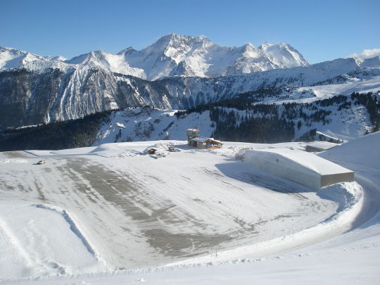
Courchevel Altiport: A tiny airfield nested into the Alps
Opened immediately adjacent to the large ski resort of Courchevel in the Trois Vallées region of France, this altiport (a word referring to an airport located at a high location specifically coined for this airfield) is located 2007 m (6585 ft) above sea level, a record in Europe. It has a tiny 537 m (1761 ft or 0.333 miles) tarmac runway with the highest gradient of any tarmac runway worldwide, at 18.6 %. At the end of it, the ground opens up to reveal a slope. The drop can be up to 300 m (984 ft).
Born out of the idea to improve the connectivity of ski resorts, preparations for the first flights began in 1961 and the first plane landed on January 31, 1962. Initially, passengers had to ski to their planes. A hangar exists as well as a caterpillar to groom the runway, but an instrument landing system is not available.
Due to the difficult terrain that allows no aborted take-offs and the short runway length a special qualification is required from a pilot wanting to land on Courchevel Altiport, as with the mountains and slopes around the airfield any mistake could prove to be fatal.
Commercial air traffic is limited both by law and by the fact only few airplanes are able use the airfield, such as Twin Otters or the Swiss-made Pilatus PC-12. Another model from the same manufacturer, the PC-6, was used during the shooting of the James Bond movie Goldeneye that took place in Courchevel. The 007 movie Tomorrow Never Dies was also shot in Courchevel.
The airfield today is mostly used by helicopters and private planes. it is also a popular starting location for scenic flights to Mont Blanc, Europe’s tallest mountain outside the Caucasus Mountains.
More information:
Video of a landing and a take-off
Privatefly.com: Courchevel Airport by private charter
Alpine-airlines.com: Courchevel Altiport Altiport access authorization. History of the Courchevel altiport (at the bottom of the page)
Pilatus-aircraft.com: Courchevel Altiport – Mit dem PC-12 durch Europa direkt ins Skigebiet (June 8 2021)
Andy Herzog: Altiport-Courchevel - der "Flugzeugträger" in den Alpen (Austrianwings.info, April 1 2013)
Image sources:
Topmost image: qwesy qwesy, CC BY 3.0, via Wikimedia Commons
Second image from top: Piponwa, CC BY-SA 3.0, via Wikimedia Commons
Third image from top: Peter Robinett, CC BY 2.0, via Wikimedia Commons
1 note
·
View note
Video
Landing at Meribel Altiport #meribel #altiport #ryannavion #navion #pbsflight #sundern #sauerland #hsk #nrw #nordrheinwestfalen #fullmotionsimulator #ilovetofly (hier: PBS Flight Simulation) https://www.instagram.com/p/B9RkQ-qIZl_/?igshid=1vcxnuvwtw38v
#meribel#altiport#ryannavion#navion#pbsflight#sundern#sauerland#hsk#nrw#nordrheinwestfalen#fullmotionsimulator#ilovetofly
0 notes
Text
Pogacar wins in one breath at Peyragudes ahead of Vingegaard, the Yellow Jersey
Pogacar wins in one breath at Peyragudes ahead of Vingegaard, the Yellow Jersey
The Slovenian triumphed at the top of the Peyragudes altiport, where he took four small seconds from Jonas Vingegaard, more Yellow Jersey than ever. Tadej Pogacar winner. But not by knockout. Arrived closely followed by the Yellow Jersey Jonas Vingegaard in the terrible last percentages (17%) of the Peyragudes altiport, the Slovenian ended up triumphing at the top just in front of the Dane, who…

View On WordPress
0 notes