#aeolis mons
Explore tagged Tumblr posts
Text
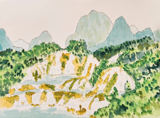
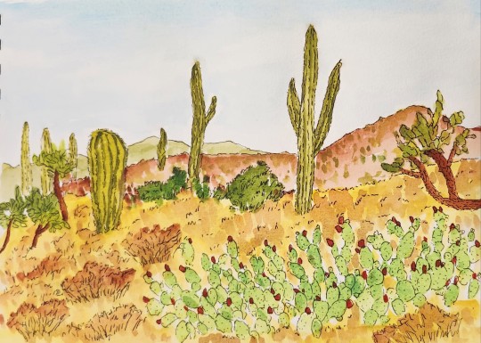
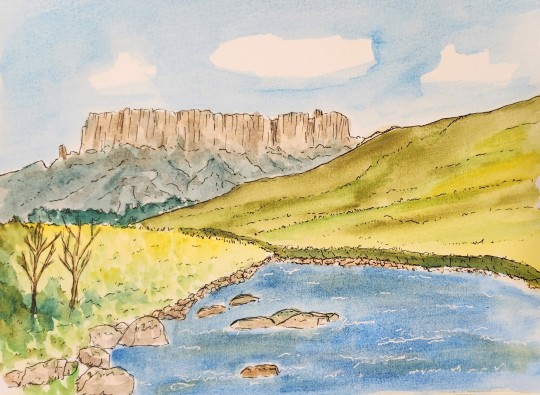
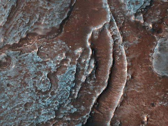
December '23 Challenge: Ink & Wash Landscapes (Part 3)
[Part 1] [Part 2]


17. Ogooué River, Lope National Park, Gabon
18. Rothbury, Northumberland, England, UK
19. Laguna Colorada, Eduard Avaroa Andean Fuana National Reserve, Bolivia
20. Ban Gioc Falls, China/Vietnam Border
21. Bear Gulch Reservoir, Pinnacles National Park, California, USA
22. Saguago National Park, Arizona, USA
23. Yuruani-tepui, Canaima National Park, Bolivar State, Venezuela
24. Aeolis Mons aka Mount Sharp, Gale Crater, Mars
And done! A little late, but c'est la vie. On to January's project!
#ogooue river#lope national park#gabon#rothbury#northumberland#laguna colorada#bolivia#ban gioc falls#china#vietnam#bear gulch reservoir#pinnacles national park#california#canaima national park#venezuela#saguago national park#arizona#aeolis mons#mars#watercolors#ink and wash#art challenge#painting#landscapes#december 2023#yuruani-tepui#mount sharp#curiosity rover#glen crater#nasa
4 notes
·
View notes
Link
On May 30, NASA’s Curiosity Mars rover, currently exploring Gale Crater on the red planet, drove over a small rock on the Martian surface. The rock cracked open while driving over the rock, revealing its interior composition. Scientists on Curiosity’s team were stunned to find yellow sulfur crystals within the rock — the first time these crystals have been spotted on Mars. What’s more, the rock these crystals were found in is made of elemental, or pure, sulfur, unlike the more common sulfur-based minerals Curiosity has previously detected. Since October 2023, Curiosity has been investigating a region of Gale Crater rich with sulfates, a kind of salt that forms as water evaporates and contains sulfur. Scientists aren’t yet sure if there is a connection between the pure sulfur found in the rock and the sulfur-based rocks that have been found in the past. Sulfur can only form in a very narrow set of conditions. Curiosity’s scientists haven’t associated the region the rover is exploring with these conditions, which is why the team was shocked by sulfur crystals within the rock. This also isn’t the only rock in this region like this — the team has since identified an entire field of similar rocks in the area around the rover. The rock Curiosity drove over and subsequently discovered sulfur crystals within. (Credit: NASA/JPL-Caltech/MSSS) “Finding a field of stones made of pure sulfur is like finding an oasis in the desert. It shouldn’t be there, so now we have to explain it. Discovering strange and unexpected things is what makes planetary exploration so exciting,” said Ashwin Vasavada, a Curiosity project scientist at NASA’s Jet Propulsion Laboratory (JPL) in California. See AlsoCuriosity Mission UpdatesSpace Science CoverageNSF StoreClick here to Join L2 In September 2014, Curiosity began climbing Mount Sharp (also referred to as “Aeolis Mons”), a large 5.5 km tall mountain in the center of Gale Crater. Along its trek up, Curiosity has explored several different regions of the mountain. Its latest stop was at the Gediz Vallis channel — a large groove in the side of Mount Sharp that winds down to the base of the mountain. Each layer of Mount Sharp that Curiosity encounters on its climb represents a different part of Mars’ history. Gediz Vallis is one of the main reasons Curiosity’s science team selected Gale Crater as the rover’s landing location before its launch in 2011. The team believes that the channel was carved out by large and long flows of liquid water and debris. In addition to the channel’s geographical nature, the 3.2 km-long ridge of boulders and sediment that extends down the mountain is evidence for these water flows. When Curiosity arrived at the channel, the team’s main goal was to develop an understanding of how the landscape was carved billions of years ago. Since then, Curiosity has studied whether ancient floods or landslides formed the ridge that rises from the channel’s floor. Curiosity’s findings suggest that both floods and landslides played a role in some way, as some of the sediment and rock piles in the ridge appear to be left by violent flows of water. Other piles appear to be the result of landslides. Panoramic image of the Gediz Vallis channel, taken by Curiosity. (Credit: NASA/JPL-Caltech/MSSS) To reach these conclusions, the team commands Curiosity to investigate various rocks found within the debris piles, as the shapes and appearance of these rocks help determine their past and origin. For example, rounded stones that look similar to river rocks were likely carried by water flows, whereas angular rocks were likely deposited by dry avalanches. Once all of these rocks settled into their mounds within the ridge, water soaked into all of the material. This water then caused chemical reactions that likely created the sulfur-based and pure sulfur rocks that Curiosity is now discovering. “This was not a quiet period on Mars. There was an exciting amount of activity here. We’re looking at multiple flows down the channel, including energetic floods and boulder-rich flows,” said Planetary Science Institute scientist Becky Williams, who also serves as the deputy principal investigator of Curiosity’s Mastcam instrument. The team’s initial expectations for their findings in the channel were much less complex than expected. The more Curiosity explores, the more complex the region becomes, and the team was eager to drill into of one of the rocks in the channel to better understand its composition and history. On June 18, they got their chance as Curiosity drilled into a large sulfur rock named “Mammoth Lakes” using its drill at the end of its two-meter-long robotic arm. Most sulfur rocks are too small and brittle to be drilled into and sampled, but Mammoth Lakes was an exception. Even with Mammoth Lakes’ large size, though, the team had to search for a part of the rock that would allow for safe drilling and sampling. What’s more, the team had to find a safe spot for Curiosity to park while it drilled, as the surrounding surface was loose and sloping. After drilling into Mammoth Lakes — the 41st time the rover had performed drilling during its mission — the rover poured the now-powdered rock into a set of instruments inside of the rover. Those instruments have since investigated the rock, and teams are now analyzing the data from those instruments to learn more about the rock and its internal composition. After successfully drilling into Mammoth Lakes, Curiosity drove away and is currently exploring other areas of the channel to learn more about its history and what it means for Martian history. (Lead image: Curiosity takes a selfie at the Murray Buttes region of Mount Sharp. Credit: NASA/JPL-Caltech) The post Curiosity discovers pure sulfur rocks, continues to explore Mount Sharp on Mars appeared first on NASASpaceFlight.com.
26 notes
·
View notes
Text


HiPOD: A Mound with a View
Gale is an impact crater with a very large mound of material in the middle known as Aeolis Mons (informally named Mount Sharp). If you were standing on Mount Sharp, you would see a diverse range of landforms on the floor and interior walls of Gale Crater such as deltas, alluvial fans, layered deposits, ridges, dunes, and smaller impact craters. Together these landforms tell an interesting geologic story that records the interaction of several processes including water and wind.
This image from the southern floor of Gale Crater shows narrow curvy ridges that connect to larger fan-shaped deposits. These narrow ridges were once the floor of a channel that are now standing in positive relief because the finer-grained material on the flanks of the channel has been blown away by the wind. These ridges, called “inverted channels,” can form by fluvial (produced by streams) or alluvial (created when water moves and deposits sediment) processes. Inverted channels are found in several places on Mars as well as Earth and scientists can study these landforms to understand the role of water.
ID: PSP_006288_1740 date: 29 November 2007 altitude: 268 km
NASA/JPL-Caltech/UArizona
75 notes
·
View notes
Text
Una vista dell’interno di Gale
Gale è un cratere da impatto con al centro una grande montagna di materiale noto come Aeolis Mons (informalmente chiamato Monte Sharp). Se ci si trovasse sul Monte Sharp, si vedrebbe una vasta gamma di forme del terreno sul fondo e sulle pareti interne del cratere Gale, come delta, ventagli alluvionali, depositi stratificati, creste, dune e piccoli crateri da impatto. L’insieme di queste forme di…

View On WordPress
0 notes
Photo


Curiosity heading to Mars’s major geochemical boundary Gale Crater, the landing site for the Curiosity Rover, was chosen as the target for several reasons. First and foremost, the goal of this rover was to verify that Mars could contain a “Habitable environment”, by which scientists mean that there was fairly fresh water present for long times. The rover accomplished that mission in its first few months on Mars by verifying that it was sitting on lake sediments that contain clay minerals, both of which require the presence of substantial amounts of water for thousands of years or more.
The presence of clay minerals in Gale Crater was expected based on analyses from the CRISM spectrometer on the orbiting Mars Reconnaissance Orbiter spacecraft, but verifying their presence on the ground and seeing the type of rocks that held them was vital to verifying that Gale could have once held a habitable environment. But it turns out that other analyses from the CRISM spectrometer told us something else about Gale Crater, and we might get to see those rocks later this year. Gale Crater contains a gigantic mound of layered sediments at its center. The official name of that 5-kilometer-high mound of sediments is Aeolis Mons, but it is also famously named Mount Sharp after Caltech Geologist Bob Sharp (who also contributed a lot to early planetary geology by working with Apollo mission astronauts). One of the rules from geology for how you interpret layered sedimentary rocks is the law of superposition, which basically says that in layered sedimentary rocks, the oldest layers are at the bottom and the youngest layers are on the top. The Curiosity Rover landed at the bottom of Gale Crater, and it has been gradually starting to ascend Mount Sharp through a valley on the slope. That means the rocks at the bottom of the mound were the oldest, and the rover is now marching through Mars’s geologic history. We know, in part thanks to the Curiosity Rover, that Mars once had a wet enough surface to support the presence of lakes. However, today Mars does not have lakes at its surface; the surface is dry, frozen, and salty. That means at some point, Mars underwent a permanent climate transition; it went from being wet and fairly temperate to dry, frozen, and salty. The water that was there must have gradually disappeared and dried up. This type of transition is one that should be preserved in the rocks. Rocks that formed with substantial water should be clay-rich, while later rocks should be richer in salts. It turns out that Mount Sharp seems to have this boundary preserved right in the middle of its layers. The lowermost layers on Mount Sharp are clay rich, but higher up on the slopes there are layers richer in sulfates, which indicate higher salt contents. In other words, as the rover climbs Mount Sharp, it should be able to see geologic evidence of the planet drying. This year, the Curiosity Rover is heading to that boundary, between the older clay-bearing unit and the younger sulfate-bearing, salty unit. How will the layers differ across this boundary? Is the transition sharp or gradual? What other types of structures might we see in the salty unit that are different from the clay-rich unit? We might get to answer those questions this year. -JBB Image credits: Caltech/JPL/NASA/MSSS https://mars.nasa.gov/resources/25097/curiositys-path-to-the-sulfate-bearing-unit/?site=msl https://www.wikiwand.com/en/Mount_Sharp
#Gale crater#curiosity#rover#nasa#mount sharp#aeolis mons#mountain#sediment#stratigraphy#superposition#geology#salt#dry#research#the universe#the real universe
25 notes
·
View notes
Photo


6/08/2018 Science Magazine: NASA Curiosity rover hits organic pay dirt on Mars
#Mars#curiosity rover#molecules#life on mars#science#discovery#NASA#Aeolis Mons#mudstone#drill#organic#ancient#life#fossilized#kerogen#geology#building blocks of life#red planet#martian#space
1 note
·
View note
Text
This self-portrait of NASA's Curiosity Mars rover
This self-portrait of NASA's Curiosity Mars rover shows the vehicle at "Namib Dune," where the rover's activities included scuffing into the dune with a wheel and scooping samples of sand for laboratory analysis.
#Red Planet (film)#NASA#Martian#Mars#Jet Propulsion Laboratory#Gale (crater)#Earth#Dune#Curiosity (rover)#Aeolis Mons
0 notes
Photo

Late Afternoon on Mars : Shadows grow long near sunset in this wide panoramic view from the Curiosity rover on Mars. Made with Curiosity's navcam, the scene covers about 200 degrees from north through east to south (left to right), stitched together from frames taken by the Mars rover on sol 2616. That's just Earth date December 16. Curiosity is perched on top of a plateau on Western Butte. The distant northern rim of Gale crater is visible along the left. Near center is Central Butte, already visited by Curiosity. On the right, the shadow of the rover seems to stretch toward the base of Aeolis Mons (Mount Sharp), a future destination. The monochrome navcam frames have been colorized to approximate the colors of the late martian afternoon. via NASA
231 notes
·
View notes
Photo

View from within Gale crater by the Mars Curiosity rover (possibly of Aeolis Mons or the crater edge); 4° 43′ 24.978576″ S, 137° 22′ 21.894528″ E
Credit: NASA/JPL-Caltech/MSSS
1 note
·
View note
Photo

2019 December 20
Late Afternoon on Mars Image Credit: NASA, JPL-Caltech, Marco Di Lorenzo
Explanation: Shadows grow long near sunset in this wide panoramic view from the Curiosity rover on Mars. Made with Curiosity's navcam, the scene covers about 200 degrees from north through east to south (left to right), stitched together from frames taken by the Mars rover on sol 2616. That's just Earth date December 16. Curiosity is perched on top of a plateau on Western Butte. The distant northern rim of Gale crater is visible along the left. Near center is Central Butte, already visited by Curiosity. On the right, the shadow of the rover seems to stretch toward the base of Aeolis Mons (Mount Sharp), a future destination. The monochrome navcam frames have been colorized to approximate the colors of the late martian afternoon.
∞ Source: apod.nasa.gov/apod/ap191220.html
28 notes
·
View notes
Photo

Late Afternoon on Mars via NASA https://ift.tt/2Z8WrvE
Shadows grow long near sunset in this wide panoramic view from the Curiosity rover on Mars. Made with Curiosity's navcam, the scene covers about 200 degrees from north through east to south (left to right), stitched together from frames taken by the Mars rover on sol 2616. That's just Earth date December 16. Curiosity is perched on top of a plateau on Western Butte. The distant northern rim of Gale crater is visible along the left. Near center is Central Butte, already visited by Curiosity. On the right, the shadow of the rover seems to stretch toward the base of Aeolis Mons (Mount Sharp), a future destination. The monochrome navcam frames have been colorized to approximate the colors of the late martian afternoon.
(Published December 20, 2019)
3 notes
·
View notes
Photo

Late Afternoon on Mars Shadows grow long near sunset in this wide panoramic view from the Curiosity rover on Mars. Made with Curiosity's navcam, the scene covers about 200 degrees from north through east to south (left to right), stitched together from frames taken by the Mars rover on sol 2616. That's just Earth date December 16. Curiosity is perched on top of a plateau on Western Butte. The distant northern rim of Gale crater is visible along the left. Near center is Central Butte, already visited by Curiosity. On the right, the shadow of the rover seems to stretch toward the base of Aeolis Mons (Mount Sharp), a future destination. The monochrome navcam frames have been colorized to approximate the colors of the late martian afternoon. December 20, 2019 via Space https://ift.tt/2Z8WrvE
2 notes
·
View notes
Photo

HiPOD 8 Mar 2022: Stratigraphy of Aeolis Mons in Gale Crater
The purpose of this image is to study features similar to those being explored by the Curiosity rover. The rover will not be able to drive to this location, but the study of similar features at a different location can provide the context needed to interpret the geologic history.
Previously dubbed Mount Sharp, Aeolis Mons rises approximately 5.5 kilometers above the floor of the crater.
Enhanced color image is less than 1 km across and is 268 km above the surface.
NASA/JPL/UArizona
48 notes
·
View notes
Photo

#space#car#mars#rover#curiosity#planet#selfie#photography#explorer#nasa#gale crater#mount sharp#aeolis mons#espacio#marte#planeta#fotografía#explorador#monte sharp#cráter gale
0 notes
Photo

Late Afternoon on Mars Shadows grow long near sunset in this wide panoramic view from the Curiosity rover on Mars. Made with Curiosity's navcam, the scene covers about 200 degrees from north through east to south (left to right), stitched together from frames taken by the Mars rover on sol 2616. That's just Earth date December 16. Curiosity is perched on top of a plateau on Western Butte. The distant northern rim of Gale crater is visible along the left. Near center is Central Butte, already visited by Curiosity. On the right, the shadow of the rover seems to stretch toward the base of Aeolis Mons (Mount Sharp), a future destination. The monochrome navcam frames have been colorized to approximate the colors of the late martian afternoon. Image Credit: NASA, JPL-Caltech, Marco Di Lorenzo #natskies #observatory #NASA #Mars #Curiosity #Curioistyrover #Earth #photooftheday #picoftheday #astronomy #knowledge #study #gallery #amazingmars #DiscoverWithNatskies
1 note
·
View note
Text
Late Afternoon on Mars

Shadows grow long near sunset in this wide panoramic view from the Curiosity rover on Mars. Made with Curiosity's navcam, the scene covers about 200 degrees from north through east to south (left to right), stitched together from frames taken by the Mars rover on sol 2616. That's just Earth date December 16. Curiosity is perched on top of a plateau on Western Butte. The distant northern rim of Gale crater is visible along the left. Near center is Central Butte, already visited by Curiosity. On the right, the shadow of the rover seems to stretch toward the base of Aeolis Mons (Mount Sharp), a future destination. The monochrome navcam frames have been colorized to approximate the colors of the late martian afternoon. December 20, 2019 from NASA https://ift.tt/2Z8WrvE via IFTTT
1 note
·
View note