#Red2Med
Explore tagged Tumblr posts
Text
Op-ed: Finally high speed? Egypt’s Long awaited HSR Line 1.
One of the most important projects in Egypt to date, albeit requiring (some) urgent extensions to fulfill its potential.
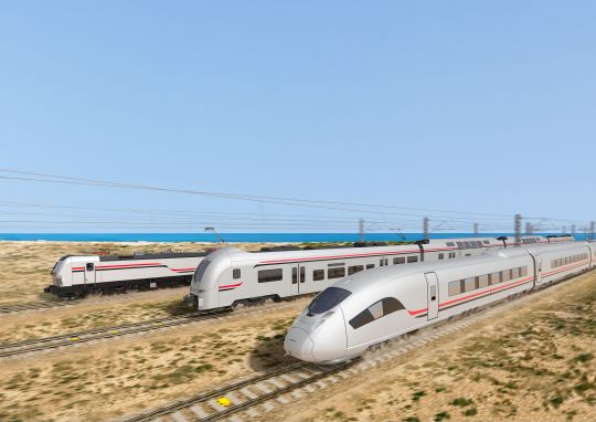
Picture 1: Rendering of the new HSR trains from Siemens press relase, date 28th of May 2022. (Source: Siemens)
An important disclaimer needs to be made: the analysis made here is arm–chair planning. While I am confident enough to publish this piece, this is neither a report nor is it academic. However, I think it is important to raise questions and put forward policy proposals to help make good transit even better. Also any sources used will be either hyperlinked or attached as a PDF.
Egypt’s High-Speed Railway projects provide genuine reasons for optimism. This opinion piece focuses on the High-Speed Railway (HSR) Line 1, which will run from Marsa Matrouh to Ain Sokhna, via West Alexandria and Greater Cairo.
According to the National Authority for Tunnels (NAT), the national agency responsible for the construction of HSR 1, along with Siemens Egypt, the high-speed “express“ trains which will consist of Valero trainsets (akin to Germany’s ICE trains) will reach a top speed of ca. 230 km/h. The “regional” trains will be based on Desiro trainsets (which are akin to Germany’s Regiobahn/ regional trains), which will run at a top speed of ca. 160 km/h.
For reference, the Cairo-Alexandria railway corridor is ca. 200 km. Due to the current conditions of the legacy railway mainline (run by Egypt National Railways - ENR) and factoring in the other stops in between, the train ride between Cairo and Alexandria takes around 3 hours. For other express trains on the line, such as the new Talgo trains, that journey could take up to 2 hours and 30 minutes. The Talgo trains have a top speed of 160 km/h but due to the stops and the conditions of some of the railway segment, the average speed is 80 km/h.
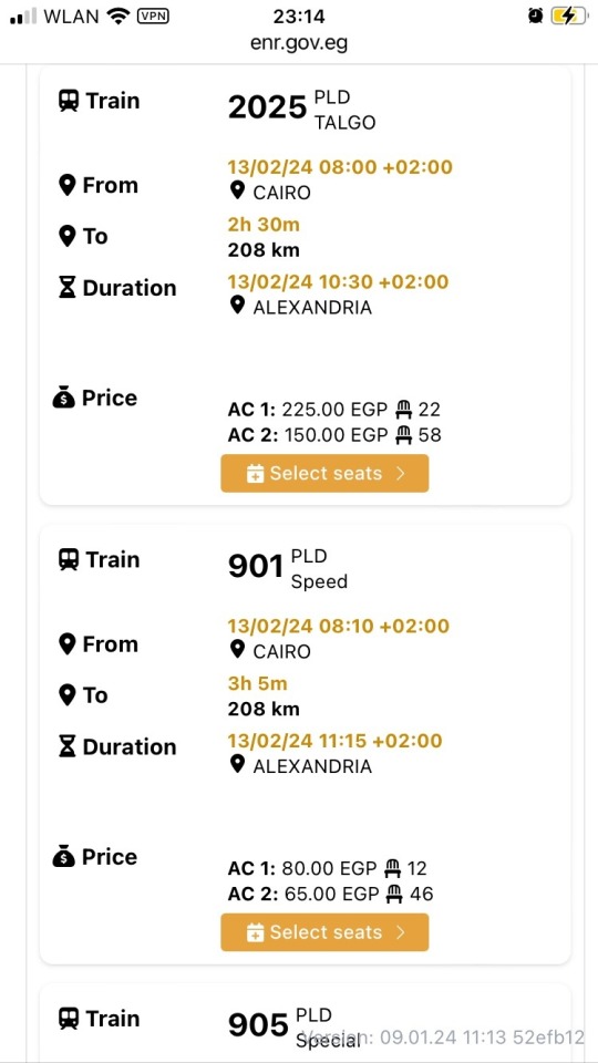
Picture 2: Screenshot showing the average time and distance between Cairo and Alexandria. Notice duratiom difference between Train 2025 (a Talgo train) and 901 a regular “speed” train (Source: ENR official booking website).
With HSR 1, there will be an alternative train route from Cairo to Alexandria (via the area adjacent to the Cairo-Alex Desert Road) that runs on dedicated high speed railway tracks, and will connect Cairo to the North Coast area; the latter only serviced at the moment by a low-frequency legacy single track that runs from Alexandria to Marsa Matrouh. The railway line as it is currently planned, is already going to be a great addition to the Egyptian transport network.
However, some issues can hinder achieving the potential this HSR line has for commuters and travelers alike. Those issues include the distance between the Cairo HSR stations and the nearest urban agglemoration or metro station. Also, many missed opportunities to connect important facilities and areas within the vincinity of the new HSR. Implementing solutions to close these gaps will be a change changer for sustainable mobility in Egypt and would be a good step forward in encouraging the transition to sustainable mobility across the Middle East and North Africa.
What is HSR 1?
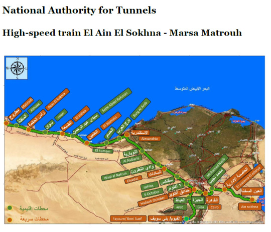
Picture 3: An official map of the HSR Line 1. Stations in green are designated as “Regional” and those in orange are “Express” stations. (Source: National Authority of Tunnels (NAT), Egypt)
The Line begins from Marsa Matrouh on the western end of Egypt’s Mediterranean North Coast, passing by the North Coast towns and cities until Alexandria, then heading to the Greater Cairo Region, passing by the further most western parts of the Nile Delta, before it crosses over the Nile, encircling Giza and Cairo proper, then passes by the outermost outskirts of New Cairo and the New Capital, before terminating at Ain Sokhna on Egypt’s Red Sea. It is, so far, the only direct true RED2MED (Red Sea to Mediterranean Sea) rail link in existence. In addition, there is a planned short link to the Fayoum, south of Giza.
Here is a list of the railway stations along the line:
Legend:
LRT: Light Rail Transit
NAC: New Administrative Capital
HSR: High-Speed Rail
→: Branch off the mainline.
Express: Serviced mainly by Valero trainsets.
Regional: Serviced mainly by Desiro trainsets.
Table 1: A list of the stations and their planned intermodality. (Source: Own work)
One of the issues noticed, from analyzing the information provided online and in the media, and by having a look at Google Earth's latest imagery, one finds that the moment the railway bends away from the North Coast towards Greater Cairo, we start seeing missing connections and gaps.
Below is a breakdown of the issues that I believe are a hinderance to achieving a higher future revenue and utilization of the HSR line 1.
Borg ElArab Int. Airport: passing by but not stopping?

Picture 4: Borg ElArab airport, the only civilian airport that currently serves Alexandria and Borg ElArab area. It also is popular with budget airline travelers, including those heading to Giza and Cairo. (Source: felekmaster, wikimedia).
That didn’t matter much as the railway service on the legacy route served the rural hinterland of the North Coast, and the capacity of the legacy rails there prevented increasing services that could have been useful to the airport.
The North coast section of HSR 1 goes parallel to the legacy railway line from Marsa Matrouh until the town of Borg ElArab, after which it diverges into two sections: a section going to Alexandria in the East, and a section that is the continuation of the main HSR line heading southeast. It disturbingly passes by the Airport perimeter, on both its North and East sides, without having a single station or set of tracks heading to the Passenger Terminal.
This will prove crucial in the future, as Borg ElArab airport is set to expand even further and a second passenger terminal, leading to increased traffic in the area.
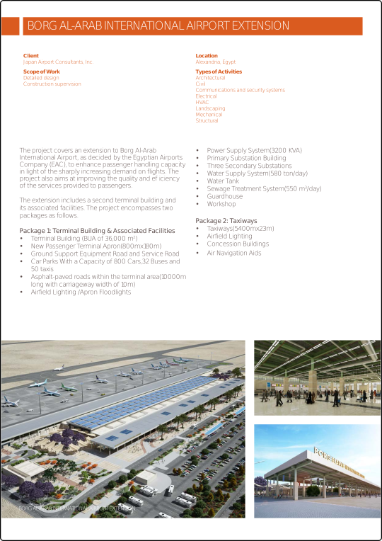
Picture 5: Brochure by Japan Airport Consultants, retrieved from the Engineering Consultants Group SA’s website , detailing the planned expansion of Borg ElArab Airport and Terminal 2’s capacity. (Source: ECGSA.com)
Sadat City station: a tad out of reach?
The station dedicated to Sadat City, a sprawling new town northwest of Cairo, is not directly adjacent to any of the city’s main districts or even close to the city limits. This issue could have been prevented had the station’s location moved around 2 km North West, where it would have been at a nearer location to the city limits. Just moving the station 2 km in that direction makes it easier for those commuting to and from Sadat City to access the HSR line.

Picture 6: Sadat city HSR is ca. 2 km, as the crow flies, from the city limits (shown on maps as dotted red line) of the city it aims to serve. (Source: Google Maps)
Sphinx Airport and Smart Village: why not?
Between Sphinx and 6th of October city, there is a wide gap without a railway station (neither express nor regional) despite the HSR 1 mainline passing by yet not serving Sphinx International Airport (Cairo’s 2nd International airport), Smart Village (a business park with many financial and telecommunications corporations) and AbuRawash Industrial area.
6th of October City: an oversight in need of correcting!
Despite its importance as a major inter-modal node with the Monorail West line, and being in the heart of a major metropolitan area like 6th of October city, it’s currently designated as a “Regional” only station. This obviously needs to change.
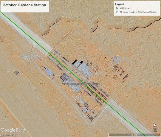
Picture 8: Screenshot of the October Gardens station from Google Earth (Source: Own work using Google Earth)
Although the nearby station “October Gardens/Hadayek October” is planned to be an intermodal station for lines 1 and 2, it is far more logical and far more efficient and revenue minded to either designate the 6th of October station as the intermodal station between HSR 1 and 2, since the area around the station is already built up and central to the 6th of October city. Also, the Monorail West line station is nearby, therefore connecting to other parts of 6th of October city and Giza.

Picture 9: Screenshot of the 6th of October station from Google Earth (Source: Own work using Google Earth)
South Giza: Blocked path?
The new South Giza HSR station is being built on the path of the former railway curve leading from the ENR mainline to the Wahat line. Instead of keeping the railway curve and utilizing it within the station as a potential for quick platform change station, and possibly a cheaper way to connect the HSR to the mainline in the future, the tracks were removed, and station was built atop it.
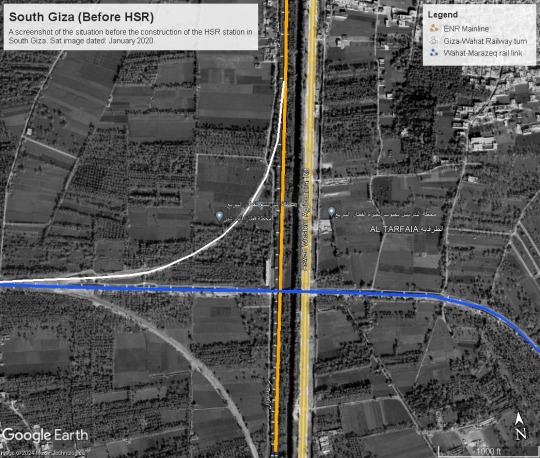
Picture 10: Screenshot of the South Giza area before the start of the HSR construction works, from Google Earth (Source: Own work using Google Earth)

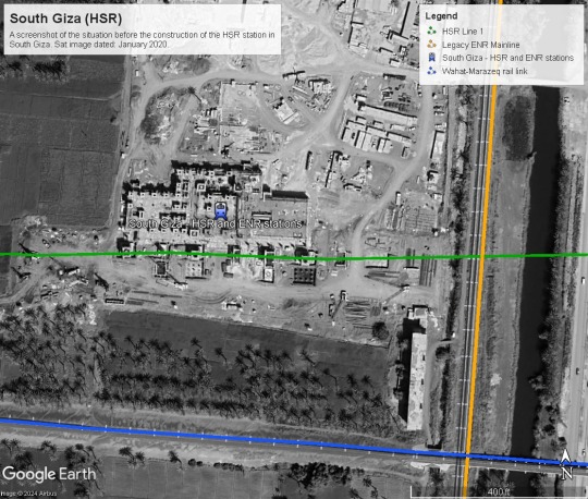
Pictures 11 and 12: Screenshot of the South Giza new HSR and ENR multimodal station. See how a new railway station is being built atop the now demolished Giza-Wahat railway curve. (Source: Own work using Google Earth)
South Cairo/Helwan HSR: A bit far?
Despite being the only HSR station that is within the city limits of Cairo proper, it is by far the farthest station of all to central Cairo. It will be a great service to the residents of Helwan, of course, and that is a positive aspect. However, the Helwan Metro station is a Kopf Bahnhof/ Terminus station, meaning an expansion of the line 1 metro to meet the new railway will be unfortunately out of the question in the foreseeable future.
The closeness of the often overlooked Marazeq bridge, on the other hand, might come to the HSR’s rescue.
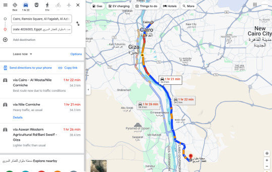

Pictures 13 and 14: Screenshots from Google Maps, with live traffic view, showing how long it would take to travel from Downtown Cairo to the Helwan HSR on an average weekday at 6:15 pm Cairo time (06/02/2024). (Source: Google Maps).

Picture 15: Screenshot of the Helwan Metro terminal station from Google Earth (Source: Google Earth).

Picture 16: Screenshot of Google Maps, with live traffic view, showing how long it would take to travel from the nearest metro station (Helwan) to the new HSR station in South Helwan, on an average weekday at 6:30 pm Cairo time (06/02/2024). (Source: Google Maps).
Mohamed Nagiub's New Cairo station: not even close.
This HSR station is supposed to serve New Cairo and is named after one of its main avenues (Mohamed Nagiub axis). The station lies 9 km south of the current southern limits of New Cairo city. The area around the station definitely has potential for transit-oriented development/ small rail town, being in the desert and not surrounded by any other development or agricultural works except by a powerline and a highway.
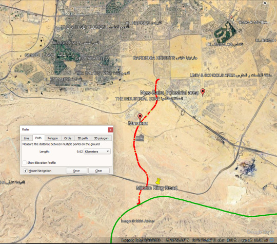
Picture 17: Screenshot of Google Earth’s ruler feature to measure the road path from the new Mohamed Nagiub HSR station to the nearest ‘edge’ of New Cairo. The distance from the station to the nearest New Cairo proper residential area is ca. 9 km. Marakez is closer but is still some 6 km away from the station. (Source: Google Earth)

Picture 18: Screenshot from Google Earth showing the new Mohamed Nagiub HSR station being constructed and its surroundings. Sat image dated 5/4/2023. (Source: Google Earth)
What can be done to fix HSR Line 1?

Picture 19: Can Egypt’s future Express trains be as successful and popular as its German ICE counterpart? The door is open to make that happen now, while construction works are still underway.
(Source: Flickr.d5e via Wikimedia Commons, CC4.0 license. Photo description: Center coach with open door of Deutsche Bahn, BR 412 ICE 4 train, heading to Frankfurt Main, Süd, taken in Berlin Ostbahnhof)
1-: Changing the designation of certain stations to "Express railway"
Starting from the cheapest of interventions to fix the HSR 1, the following stations need to be immediately designated as dual-use stations (both express and regional trains) or as half-express (fewer Express trains/more regional trains): Burg AlARab/Borg ElArab, 6th of October City, South Giza, Mohamed Nagiub.
Cost: Zero.
How:
A schedule that differentiates between Sprinter trains that don’t stop at smaller stations. The remaining Express trains can stop at an alternate set of stations. Hence, keeping the number of extra stops low and the duration of the journey manageable. eg. Sprinter trains to stop only at the main Express station. Then have the configuration of trains, that stop either at all express stations, then stop at 6th of October city, then Mohamed Nagiub. The alternating configuration could then stop at express stations, plus Borg ElArab, and South Giza.
Even though these regional stations are not getting full express train service, having at least these alternating services will make it easier for folks to plan their commutes around express trains if they need to, and use the regional trains if they want to spontaneously or to travel a few stations up or down the line.
Tip: DB already does this on many of its routes in Germany.
2- Closing the HSR and ENR gap: ENR Legacy - HSR link via Marazeq bridge
Build 1 km of new rails from West of South Cairo station to the Marazeek cargo line, repair and increase the efficiency of 6.85 km of existing railway. This includes the cargo route and the Marazeek bridge (the 2nd railway bridge in the North of Cairo, but lesser known and forgotten except by Egyptian railfans like myself).
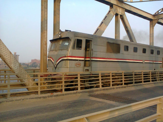
Picture 20: A photo, dated sometime in 2020, of a Henschel 3096 Diesel ENR Locomotive, going over the Marazeek Bridge. Al Marazeek bridge is a multimodal bridge (single railway track, 2 lane roadway and a pedestrian path). (Source: User “Na Na” - Google Maps)
From here we have two solutions:
2-a- least cost possible: Run Bi-mode EDMUs (like the British Rail Class 802). These trains can run on both diesel and electrical overhead wires. This would be crucial to help bridge the gap between the ENR and HSR: The class 802 can run on diesel from Cairo Central station in Ramsis Square all the way to the South Cairo/Helwan station, then switch to the electrical overhead power supply on the rest of its journey along the HSR.
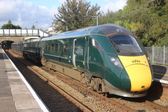
Picture 21: The British Rail Class 802 Trainset, a Bi-mode EDMU trainset manufactured by Hitaschi, operated by the Great Western Railway of the UK. These trains can run on both diesel and when available, use an overhead electric powerline. (Source: Superalbs via Wikimedia Commons, CC4.0 License)
Using bi-mode trains will allow for these routes to be possible:
Cairo central to West Alex
Cairo central to North Coast and Matrouh
Cairo central to New Cairo (see solution 3)
Cairo Central to the New Capital
Cairo is central to Sphinx and Borg ElArab Airports (see solution 3)
Cairo central to Ain Sokhna
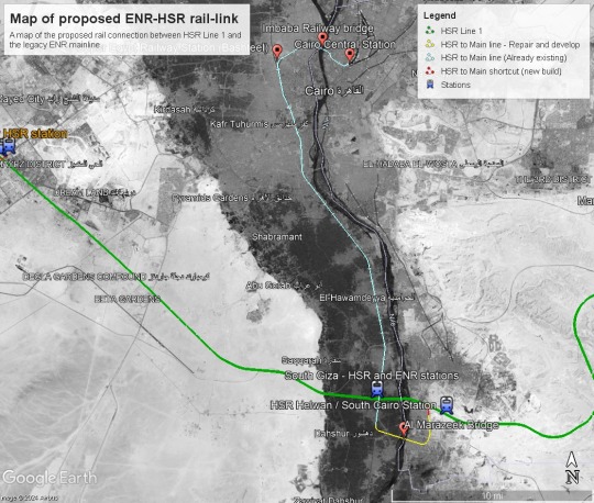
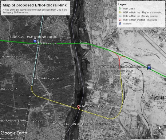

Pictures 22, 23, and 24: Maps of proposed ENR-HSR Rail-link in the Greater Cairo region (Source: Own work using Google Earth).
2-b- the future-proof yet costlier option: electrify the gap from South Cairo/Helwan to Cairo central station. This would guarantee that all of the HSR trains can enter Central Cairo and would not require the Rail Class 802 units.
How did I calculate the costs:
It’s not entirely clear how much 1 km of electrified rail costs in Egypt. However, the entire 660 km of rails, signaling systems, compensations paid, stations and the train sets cost about 4.5 billion euros.
Now if we make the very prejudiced assumption - based on the study “Economic investigation for building a high-speed rail in developing countries: The case of Egypt” by Belal et. al 2020 - that the actual Infrastructure (rails and overhead wiring etc) costs only 15% of the 4.5 billion, that means, (4.5 billion € /660 km+all stations and facilities)*0.15= 1 million € per km of rails and overhead wires.
Also, assuming that the rehabilitation of existing railways costs a third of placing a completely new set of tracks, that means rehabilitation of rails costs 333 thousand euros per km. Let’s assume that the electrification costs of existing rails costs also 333 k.
Cost of 2-A plan:
1 km of new rails: 1 million euros
7 km of rehabilitation of the existing tracks: 330 thousand x 7 km = 2.3 million Euros
Total: 3.3 million euros
Percentage of this plan to the main project expenses: 0.07 percent of the total project cost (i.e. peanuts!).
Cost of 2-B plan:
1 km of new rails: 700 thousand euros
7 km of rehabilitation of the existing tracks: 300 thousand x 7 km = 2.1 million Euros
Total: 2.8 million euros
Percentage of this plan to the main project expenses: 0.06 percent of the total project cost (i.e. peanuts!).
Cost of 2-B plan:
1 km of new rails: 700 thousand euros
7 km of rehabilitation and electrifying existing tracks: 666 thousand euros 00x 7 km = 4.6 million Euros
38 km of electrifying existing tracks (from Marazeek to Cairo Central) = 12.6 million Euros.
Total: 17.2 million euros
Percentage of this plan to the main project expenses: 0.38% of total project cost, (a bag of salted peanuts in comparison!).
My opinion on this: I think for the time being, and given the financial crisis, it is much better to resort to the EDMUs that are similar to the UK’s Great Western Rail Class 802. These were designed to run on British railways which are not only of similar age and design but were actually built by British Engineers in the 1880s. Instead of reinventing the wheel, we can simply adopt it as a literal stop-gap solution until we have more money to electrify the ENR legacy mainline.
Besides, a great chunk of the ENR network will not be electrified anytime soon. Therefore, if the section between South Cairo/Helwan and Central Cairo proves to be of popular demand and electrification then becomes due, these EDMU units can still be deployed on many other sections across Egypt’s rail network, including from Ain ElSokhna to Suez, bridging HSR and ENR networks from the Eastern end of the line.
3- Build slip paths and branch-offs
Several slip paths and branches need to be built urgently to connect crucial infrastructure and provide real accessible and intermodal transport.
3-a- Borg ElARab airport slip path and train station.


Pictures 24 and 25: Maps of proposed Borg ElArab Airport - HSR Line 1 Rail-link (Source: Own work using Google Earth).
This is an obvious slip path and absolutely necessary.
Cost:
6.5 km of new rails = 4.5 million euros
1 new station (Between T1 and the new T2 passenger buildings at Borg ElArab International Airport): 1 million euros
Total: 5.5 million euros.
3b- Sphinx Airport branch off
While Smart Village and Abu Rawash Industrial area are a tad too far for a slip path, a branch off may do the job (to connect the airport, and possibly a light rail from airport to Smart village and Abu Rawash in the future) with a main train terminus station adjacent to the Sphinx Airport passenger terminal. It would connect HSR 1 with Sphinx Airport and allow for this mix of routes to take place:
Sphinx Airport - Central Cairo
Sphinx Airport - Borg ElArab airport - this would put these airports on the map of the budget airline transit industry, with passengers changing between airports using the HSR Line 1.
Sphinx Airport - West Alex
Sphinx Airport - North Coast and Matrouh
Sphinx Airport - New Cairo
Sphinx Airport - New Capital
Sphinx Airport - Ain Sokhna
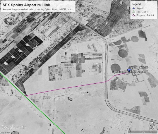

Pictures 26 and 27: Maps of proposed Sphinx Airport - HSR Line 1 Rail-link (Source: Own work using Google Earth).
4- New Cairo First mile/Last mile?
Given the massive distance of the station from the city, and the social and economic importance of New Cairo, the only long term solution is to connect the HSR to New Cairo and its passenger volume potential, is by a rail branch off.
However, some form of LRT or Sbahn-styletrain connecting the Mohamed Naguib station to New Cairo’s different districts can help establish the mobility demand at a lower budget, and that would financially support a future branch off into New Cairo.

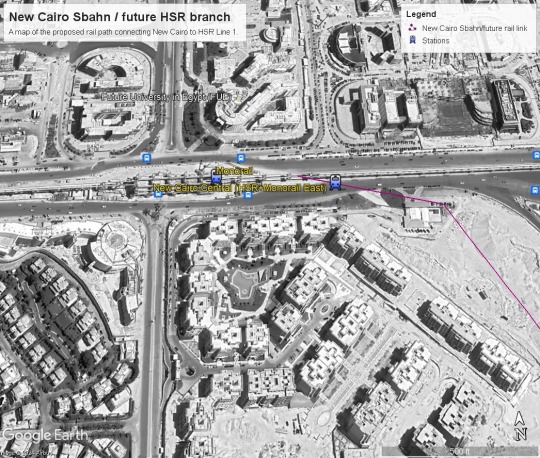
Pictures 28 and 29: Maps of proposed Mohamed Nagiub to New Cairo ‘sbahn’ link / future HSR branch (Source: Own work using Google Earth).
This may be true at Ain ElSokhna too: Where an LRT or coastal suburban line can help connect the small towns and resorts along the shore to the station.
Conclusion
The logic of these suggestions and ideas proposed here revolves around 5 key concepts:
1- Accessiblity and Intermodality:
If we want as many people as possible to benefit from the service and pay for HSR (to cover the costs and make net revenue), we need to make it as accessible and intermodal as possible. You need to reduce the number of changes at important stops (such as airports, metro/monorail/major bus stations, and terminals) by having direct connections to them. A bus from the HSR station to the nearest airport or metro station just won’t cut it for many people. Also, people traveling with luggage do not want to change more than a handful of times if ever.
2- Prioritize service to Urban areas:
Major urban agglomerations must always have their own train stops, and depending on their location and Population size, they must also be served by all types of trains (express, regional, and suburban). People living in well-established urban areas are less likely to drive to a stop more than 2 km away from the urban core. This is especially the case if the total journey time on existing trains eventually adds up to the same journey time expected, leading to no savings in time or fuel/trip costs.
3- Encourage Transit oriented development:
Whenever possible, if we have a stop next to empty undeveloped land, we should encourage the building of transit-oriented developments. These will become very much-needed and sought-after Housing units and will make maximum use of the existing railway and its adjacent services.
4- Closing the gap between the legacy and HSR systems:
In places where there is a phased transition or the construction of new railway systems, there must be a goal to close the gap between the two systems by finding ways to integrate them. This is particularly true between the HSR and ENR systems. If they both become integrated, it increases the resiliency of both systems and will help with the electrification of all the non-HSR railways, making it easier to provide new route combinations and have fewer transfers and modal changes due to the gap between electrified and non-electrified train routes.
5- Stations aren’t the end of the journeys:
If a station is not within a dense urban agglomeration, LRT or suburban rail services can help connect the station with its neighboring towns or villages.
I would even argue that in the medium and long run, it is in the interest of Siemens and DB to build these extensions and branches. In their paper, Belal et. al (2020) included a very important piece of advice to DB and Siemens:
“There is no doubt that the passenger flow (PF) on HSR is a crucial factor shown on ticket revenue. It has a direct impact on the total income of the project. Therefore, it has a significant role in project feasibility.” (page 1006)
As people in Egypt start getting to know the HSR network, folks regularly traveling between Cairo and Alexandria, for example, may begin to prefer traveling via the HSR network, if they know that they can get on an express train in Cairo Central and get to Alexandria or Borg ElArab Airport in one go, and much faster than they were used to traveling on the legacy line, that would make the HSR network a game changer of mobility in Egypt; and perhaps also benefit DB on the long run too.
Links:
#cairo#high speed rail#egypt#siemens#deutsche bahn#mobility#trains#British Rail#german railway#alexandria#Marsa Matrouh#Ain Sokhna#Red2Med#red sea#mediterranean sea
1 note
·
View note