#PeakBagging
Explore tagged Tumblr posts
Visit Tumblr Blog
Explore Tumblr blogs with no restrictions, modern design and the best experience.
Last Seen Tumblr Blogs


Fun Fact
Tumblr posted its first advertisements in May 2012 and subsequently earned $13M in revenue.
Text
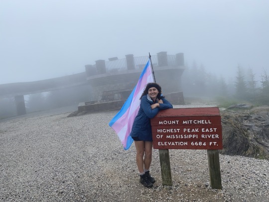
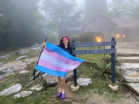
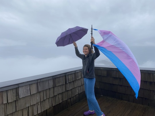
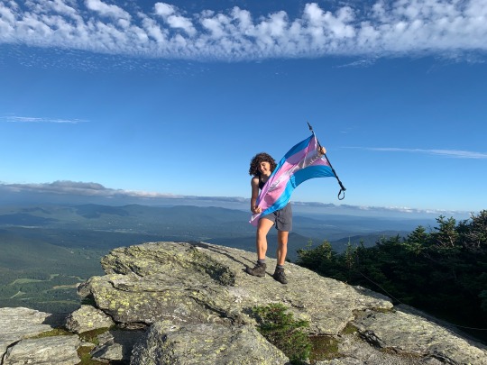
Here's some photos of me taking a trans pride flag up the tallest mountain in ten different states: North Carolina, Alabama, Tennessee, Georgia, Kentucky, Virginia, New Hampshire, New York, Vermont, and Maine!!!
Attakulla, NC - May 18th, 2023:
Cheaha, AL - April 26th, 2023:
Kuwahi, TN - April 5th, 2023:

Brasstown Bald, GA - April 26th, 2023:
Black, KY - May 1st, 2023:

Rogers, VA - May 5th, 2023:

Agiocochook, NH - July 10th, 2022:

Tahawus, NY - July 17th, 2022:

Mozdebiwajo, VT - August th, 2022:
Katahdin, ME - September 7th, 2022:

#lol flag time#trans#trans pride#queer#queer pride#pride#pride flag#lgbtq#lgbtq pride#lgbt pride#transgender#transgender pride#hiking#peakbagging
2K notes
·
View notes
Text

Alpine Morning
Morning air thin and crisp, I chased the sun across the ridgeline. The mountains held their secrets in silence—and I was grateful to listen.
0 notes
Text
2/16/25 - Two 10ers near Bailey

A friend wanted to do some hiking, and knowing that he likes to scramble, I chose UN 10,252 and UN 10,050. The latter was rated class 3 on Lists of John and I was curious what it would be like.
I am usually restricted to trailheads reachable by a sedan, but my friend has a truck, so we were able to drive pretty far up a forest service road. There were some icy ruts at the very beginning and some large erosion prevention bumps but it was mostly nice and smooth.

Starting to walk uphill through open forest, some peaks become visible behind us to the west. We will be summiting 10,252 first.

A bit higher up, bigger peaks become visible. I believe that is Rosalie Peak. Fun story - one time I found $500 on Rosalie as part of a youtuber's (kinda poorly planned) riddle/scavenger hunt.

Near the top of the first little ridge (9691 spot elevation on caltopo scanned topo layer) we walked past this pretty cool "ship's prow" boulder.

Just past this was a large open area that provided great views to the south, including Pikes and the other usual suspects. The pointy peak on the left is 10,050.

Looking towards 10,252. Up we go!
We reached the summit, going through a little snow. Not much of a view due to trees. We descended a broad gully on the east side of the peak, and then contoured over to the saddle between the two Peaks.

Some cool cliffs with 10,050 looming in the background. It looks pretty steep!
Eventually we reach the saddle and head up, aiming for the west side of the peak.

The forest transitions to talus, and then we were at the start of the scramble. I don't have great pictures, but we went up on the left side of this picture (or possibly just out of frame to the left?) and then followed a catwalk-like feature to the summit.

Another picture from the base of the scramble. I believe we went up just to the right of this picture. The scramble wasn't too bad. I downclimbed facing out the whole time, basically crab walking lmao. There was one move that was a bit awkward to downclimb with a bit of a fall possible if you were to like slip forward somehow. And another part where you had to walk along a flat ledge with some nice hand holds to your left but quite a large drop to your right. Overall, the scramble was more fun than scary, mostly just easy class 3 while you're safely wedged between large boulders. I am always a little stressed doing this kind of thing and I was very glad to reach the summit.

View from the summit towards Staunton State Park

View to the south

View towards the kenosha pass peaks

Meridian Hill

view towards Rosalie
We reversed the scramble and descended a bit west of our ascent line where it was less steep. About 2 miles of walking through nice open forest later, we reached the starting point.

a few minutes before we reached the car, I found a huge piece of very clear quartz, which made a fine addition to my collection.

This was a pretty nice hike. Almost no deadfall to deal with which is very rare for 10ers.
Total Stats:
5.6 miles
2280 ft of vert
3 hours and 34 minutes
Caltopo
0 notes
Text
Home in Hilo, Hawaii
I had the honor of receiving a scholarship through Geological Society of America to study Hawaii Volcano Eruptions for half a week, thank you to all who support this blog 😀My venmo is here: https://account.venmo.com/u/twiichiiMy REI wishlist is here: https://www.rei.com/lists/418184695 Nearly a decade ago, I lived in Hawaii and completed my senior year of undergraduate education with a BA in…
#Art#awareness#donate#education#Environmental Justice#expenses#geology#hawaii volcanoes#kilauea#mauna kea#mauna loa#minerals#multicultural#national monument#national park#national parks#natural#naturalist#nature#nature journaling#nps#pass#passes#peakbagging#peaks#permit#public transportation#REI#river#rocks
0 notes
Text
#IslandPeak#PeakClimbing#Himalayas#NepalAdventure#MountainClimbing#SummitSuccess#HighAltitudeAdventure#MountainViews#OutdoorChallenge#TravelInspiration#Wanderlust#BucketListGoals#MountainMagic#AdventureTravel#PeakBagging#ExhilaratingJourney
1 note
·
View note
Text
Baruntse Expedition: A Himalayan Adventure
The Baruntse Expedition offers a thrilling and challenging climb to one of the less technical 7000m peaks in the Himalayas, located in Nepal. Here is an overview of this exciting adventure based on the information gathered from various sources.

Expedition Highlights
Peak Details: Baruntse stands at 7129 meters and offers a unique climbing experience.
Itinerary: The expedition typically spans 35 days and includes climbing Baruntse and Mera Peak (6476m).
Guide Ratio: The expedition maintains a 1:1 guide-to-climber ratio during the summit climb and a 1:2 ratio on Mera Peak.
Route: The South-East Ridge route is recommended for its accessibility, with two camps set up along the way.
Base Camp Comfort: The base camp at 5460m provides heated dining tents and single-person tents for comfort.
Return: After the expedition, participants often return via helicopter for convenience.
Climbing Details
Route Options: While the South-East Ridge is known for its steep ice sections, the South Ridge is more popular for its accessibility.
Camps: Camp 1 is situated at 6100m, followed by Camp 2 at 6420m on the South-East Ridge.
History: Baruntse was first climbed in 1954 via the south ridge by a New Zealand expedition led by Sir Edmund Hillary.
Environmental Responsibility
Impact Awareness: Acknowledging the environmental impact, efforts are made to minimize pollution and waste at the base camp.
Initiative: Starting from the 2023 expedition season, a $50 contribution from each booking will be allocated to address environmental concerns.
Logistics and Strategy
Best Time: The ideal time for the Baruntse Expedition is typically October to November (Autumn).
Climbing Strategy: Fixed rope lines are set up by a rope-fixing team along the standard route of the South-East Ridge.
The Baruntse Expedition promises not only an exhilarating climb but also a commitment to environmental sustainability. With its rich history, challenging routes, and stunning landscapes, this adventure beckons climbers seeking both thrill and responsibility in their Himalayan pursuits.
#BaruntseExpedition#MountainClimbing#Himalayas#Mountaineering#Adventure#ExpeditionLife#PeakClimbing#AltitudeLife#SummitBid#HighAltitudeAdventure#NepalAdventure#MountaineeringExpedition#PeakBagging#ExtremeAdventure#AlpineClimbing
0 notes
Text
Colorado - Mt. Elbert Summit

Reaching new heights and soaking in the stunning views at the unforgettable Mt. Elbert Summit in beautiful Colorado.
0 notes
Text
Longs Peak by Visit Colorado... One day I'll hike this, my ultimate 14er

Dreaming of conquering Longs Peak, my ultimate 14er. One day, I'll make it happen.
1 note
·
View note
Text
Longs Peak by Visit Colorado... One day I'll hike this, my ultimate 14er

Dreaming of conquering Longs Peak, my ultimate 14er. One day, I'll make it happen.
0 notes
Photo
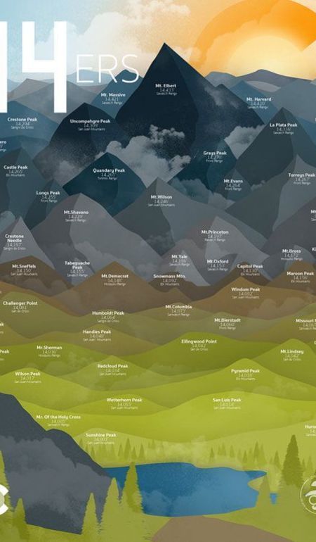
Colorado Fourteeners // DaydreamHunter Explore the majestic Colorado Fourteeners and let your mind wander with DaydreamHunter's captivating pins. Discover hidden gems and learn fascinating facts about these iconic peaks.
0 notes
Text
Hiking a trans pride flag up 131 mountains in the Northeast of the US, parts 92-93: Ossipee Area!!!
Bald Knob - 92a/131:

Turtleback - 92b/131:

Faraway - 92c/131:

Roberts - 92d/131:

Farr - 92/131:

Green - 93/131:

Sentinel - 93a/131:

Flagg - 93b/131:

Sayre - 93c/131:

More nature photos!!!


Thanks for reading this far :)
#lol flag time#trans#trans pride#pride#pride flag#queer#queer pride#lgbtq pride#lgbtq#lgbt pride#transgender#transgender pride#hiking#peakbagging#nature
465 notes
·
View notes
Text

Gypsy Nirvana 1: Portable Camping Tent for Simple Outdoor Getaways
Step into the simplicity and serenity of the great outdoors with the Gypsy Nirvana 1 tent. Designed for those who seek a minimalist camping experience, this tent offers easy setup and comfortable shelter.
Its compact size makes it perfect for solo travelers or couples looking to reconnect with nature without the fuss. Made with durable materials to withstand the elements, the Gypsy Nirvana 1 is your ideal companion for a tranquil outdoor retreat.
For more information:
Website: Gypsy Tents
Call: 09822397741, 9764805353
Visit Shop: Adventure Sports Equipments, Mehta Apts, 813/814. Bhavani Peth, Opp. Old motor stand, Pune-2
0 notes
Text

July 31, 2024
A Big Hike in the Tenmile Range
On this day I hiked some peaks in the Tenmile Range above Breckinridge. I started on a piece of the Colorado Trail from the Wheeler Trailhead (which is in one of Copper Mountain's parking lots). Once the trail delivered me to the ridge, I went over Peak 9 and Peak 10 to get to Crystal Peak. Then I side hilled around Peaks 9 and 10 to get back to the Peak 8/9 saddle. Then I followed the ridge to Peak 4 and finally went back to the trailhead. In total I summited 5 ranked peaks (Peak 4, Peak 8, Peak 9, Peak 10, and Crystal Peak) and 3 unranked (Peaks 5,6,7). One of my biggest days last summer and a very enjoyable outing.

The trail has brought me to a saddle! this is the view of Peak 9 from the saddle.

View from the saddle back towards where I came from, with the Gore Range in the background.

Heading up Peak 9, starting to get a bit rocky!

Another view back towards the saddle, with the grassy ridge I'll follow later in the day now in view.

Almost to the top of Peak 9, with Peak 10 looming behind. There is a slightly tricky section in the little dip before Peak 9. Nothing too scary, maybe one move of class 2+

Ontop of Peak 9, looking back at the tricky bit

The next two peaks on the agenda, Peak 10 (left) and Crystal Peak. Check out the steep talus I'm about to go up on Peak 10! not the funnest terrain ever. It was large-ish and not that loose. Definitely could have been worse.

Time to go up Peak 10!

View to the west featuring the talus slope

Getting pretty high up! Looking back at Peak 9

From the summit of Peak 10 (or possibly just below?) looking at Crystal and more peaks to the south including Quandary, Pacific, Atlantic. Time to go to Crystal!

Some rock glaciers to the west

Ontop of Crystal, looking south. Crystal's north ridge was pretty pleasant with some interesting rocks. I walked back to the Crystal/10 Saddle, then side hilled on talus to a road on the east side of Peak 10. I followed this road north past some mining ruins until I was past Peak 9's east ridge, where I side hilled back to the peak 8/9 saddle. I took a relatively long break and then started up towards Peak 8.

Reaching the top of Peak 8, I took this picture back towards 9, 10, and Crystal. The road is visible left of Peak 10.

Looking at the rolling grassy ridge to Peak 4. Unfortunately Peaks 5, 6, and 7 do not have enough prominence to be ranked, but there is still a bit of up and down to get over them.

There's lots of stuff up on the ridge from Breckinridge Ski Resort

Who knows which peak this is, they all sort of blurred together for me at this point. Probably Peak 4?

Looking back where I came from. Crystal is so far away

Finally at the top of Peak 4, my last peak of the day. Looking at the spiciness of Peak 3 and Tenmile Peak. Most people do the tenmile traverse instead of the route I did, but I am not a huge fan of exposed scrambling and I didn't want to deal with this part of the ridge. Also there was no need for a car shuttle with my route. Gore range looking cool in the background.

Looking back at at all the peaks from today and a lot more to the south.

Finally back on a trail below Peak 6


Some nice views on the trail down to wrap up the day.
Total Stats:
20.3 Miles
7040 ft. of vert
10 hours and 27 minutes

Caltopo
1 note
·
View note
Text
Love how on peakbagging forums there are just so many in depth discussions and helpful tips on how to commit extended trespass and not get caught.
Shout out to the one guy who has really great strategies to lie to Canada border patrol to then illegally cross back into the US to get an easier approach on Mt Rahm.
#I was looking at a weekend dumpster dive#and this guy on the forum had a detailed explanation for how to get around this logging companies camera system#like there are so many guys just tlaking about the places they plan to just trespass#and yeah this is the mountains I do not respect private company land holdings
2 notes
·
View notes
Text
#MeraPeak#PeakClimbing#Himalayas#NepalAdventure#MountainClimbing#SummitSuccess#HighAltitudeAdventure#MountainViews#OutdoorChallenge#TravelInspiration#Wanderlust#BucketListGoals#MountainMagic#AdventureTravel#PeakBagging#ExhilaratingJourney
0 notes
Text
How to prepare for successful peak climbing in Nepal ?
Nepal's peak climbing takes mountaineers to the summits of many peaks, whose altitudes range from 5,500 meters to 6,500 meters. This provides an exciting expedition for adventurers tackling rugged terrain and magnificent landscapes. Aspiring climbers can develop the physical fitness, endurance, and acclimatization required to successfully climb peaks in Nepal by focusing on these areas of development. Additionally, getting the right permits, hiring good guides, and finding the right equipment is crucial.
For detailed information and bookings, visit our website:
Address- Z Street - Thamel, Kathmandu, Nepal
Phone- +977 1 4701233
Mobile, WhatsApp & Viber- +977 9849023179 (Dipak Pande)
Email- [email protected]
Website- www.mountainrocktreks.com
#PeakClimbingNepal #HimalayanAdventures #SummitQuest #NepalClimbs #AltitudeAscents #MountainMajesty #HighAltitudeTrekking #ExpeditionLife #PeakBagging #HimalayanChallenge #AdventureSeekers #ClimbOnNepal #HimalayanJourney #Thamel #Moonlighthotel #ramadaencore #paknajol #hotelmoonlightthamel #Zstreet #mountainrocktreks #MRT2024
0 notes