#National Institute of Water and Atmospheric Research
Explore tagged Tumblr posts
Visit Tumblr Blog
Explore Tumblr blogs with no restrictions, modern design and the best experience.
Last Seen Tumblr Blogs


Fun Fact
Tumblr Inc. is funded by 13 investors.
Text
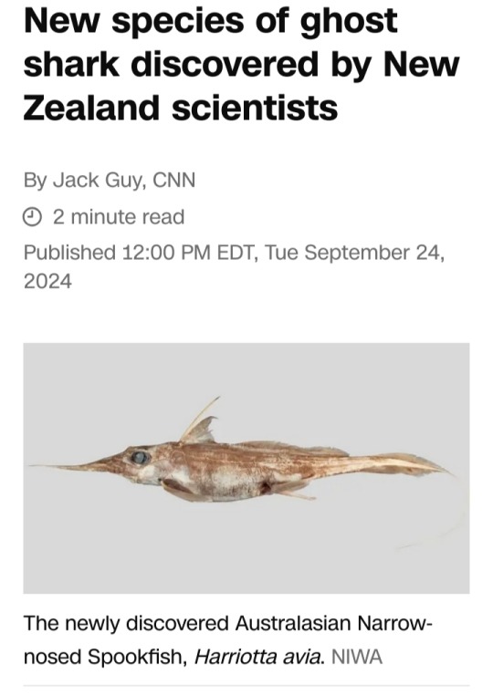

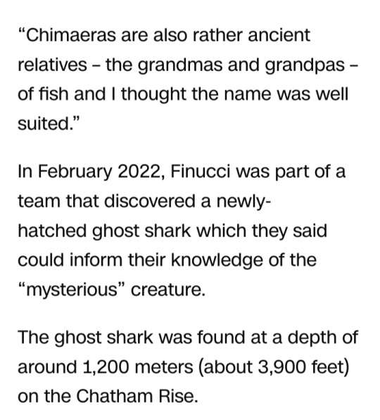

#ghost shark#Harriotta avia#Australasian Narrow-nosed Spookfish#Australia#New Zealand#Chatham Rise#National Institute of Water and Atmospheric Research#chimaera#deep water animal#cartilaginous fish#Brit Finucci
4 notes
·
View notes
Note
We got any fun little worm dudes around?
I am going to interpret that to mean WORMS (inverts), so here you are...

Disguised as deep-sea acorn worms, two species of Yoda have been found– not so long ago, on a seamount far, far from land.
Yoda purpurata, discovered in 2012 with the ECOMAR ROV on the Mid-Atlantic Ridge, sports distinctly Yoda-like lobes on either side of its head (these are lips rather than ears). In 2022, scientists using Schmidt Ocean Institute’s ROV SuBastian found its North Pacific cousin. Yoda demiankoopi bears little resemblance to the original Yoda, but is still a force to be reckoned with. You try living off of tiny scraps of marine snow at the bottom of the ocean! Yoda purpurata: David Shale/Marinespecies.org Yoda demiankoopi © Schmit Ocean InstituteImages used under Creative Commons Attribution-Noncommercial-Share Alike 4.0 License
via: Woods Hole Oceanographic Institution
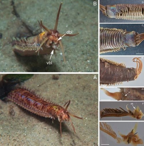
A new species of giant Eunice (Eunicidae, Polychaeta, Annelida) from the east coast of Australia
Read the paper here: https://zookeys.pensoft.net/article/86448/
youtube
Green Spoon Worm
Check out this freaky Green Spoon Worm (Metabonellia haswelli, phylum Echiura), filmed in Port Phillip Bay, Australia, on 8 Feb 2018. It may look harmless, but this marine worm can paralyze small animals using the neural poison in its skin.
via: Youtube.com
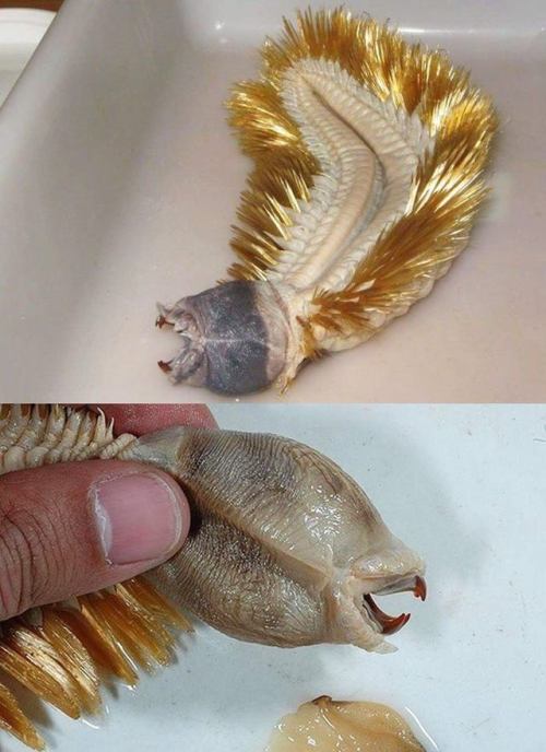
Say hello to Eulagisca gigantea, the golden worm from the Antarctic seas
from photographer Matthew Brown
It’s an Antarctic scale worm, a type of polychaete (bristle worm).There are many different species, all around the world, ranging in size, colour, and living habits. Some feed on detritus, others like this one, are predators. It’s laying on its back, those golden bristles are it’s feet, which it uses to walk along the soft sediments on the sea floor. Some species live in tunnels, those ones have greatly reduced spines. They’re a cool group of animals. Most of NIWA (National institute of water and atmosphere research) deep sea specimens like this are collected by their long range research vessel the Tangaroa. They had a lot of cool stuff, giant amphipods, isopods and giant squid etc. They’re basically trying to figure out biodiversity hot spots on the sea floor around the world in order to inform the establishment of marine sanctuaries. They also provide advice to fisheries about fish populations.
via: So Bad So Good
youtube
Weird and Wonderful: Green bomber worms drop bioluminescent “bombs"
Green bomber worms (Swima spp.) have specialized organs that explode with a burst of green bioluminescence. This impressive display is likely used to startle predators while the animal makes a speedy getaway. They live just above the seafloor and are vigorous swimmers, able to maneuver both backwards and forwards. Each worm carries up to eight “bombs.” If they lose one, they can grow it back. The “bombs” may have been gills that evolutionarily transformed over time. Although these worms lack eyes, they have developed a novel bioluminescent defense mechanism. MBARI research has shown that approximately three quarters of the animals living in the dark ocean depths are capable of producing bioluminescence.
Learn more about these amazing deep-sea worms:
https://www.mbari.org/new-species-of-deep-sea-worms-release-glowing-bombs/
273 notes
·
View notes
Text
Ok, y’all. I just want it to be understood how important the National Oceanic and Atmospheric Administration (NOAA) is.
Tampering with NOAA would have more impacts than just the main one I've heard - privatization of weather tracking. Of course it would be catastrophic. That means their weather forecasts, guidance, and warnings would not be available for free. Weather is going to go subscription based if this happens, I bet. This undoubtedly would cause the most immediate impact on our daily lives.
Before long, however, more will come.
NOAA also administers the Coastal Zone Management Act. Under this act are the National Estuarine Research Reserves (NERRs), National Coastal Management Program (CZM), and the Coastal and Estuarine Land Conservation Program (CELCP).
There are 30 reserves established totalling 1.3 million acres. More are on the way.
No, this isn’t just our oceans! This impacts our freshwater coasts of the Great Lakes.
Grants and funding for institutions, including the University of Michigan. They manage the Science Collaborative, which funds research and exchanges to address coastal management needs of all 30 reserves or projects in collaboration with them.
Blending new technologies with indigenous knowledge with regards to management of wetlands and estuaries, strengthen food and economic stability, water quality, coral reefs, and resilience against climate change (ie. Ola i ka Loʻi Wai, Hawai’i)
Restore ownership of indigenous ancestral lands (ie. Conservation of Cape Foulweather Headland, Oregon)
Identify for underwater archaeological sites for research and surveys, create a draft tribal climate action plan (ie. Penobscot Nation’s involvement in the Northeast Regional Ocean Council, Maine)
Work with each participating state (regarding the CZM, as it’s voluntary to participate) to address challenges along their coastlines. Maybe reach out to your representatives to see why they’re not involved - looking at you, Alaska!
Population enhancement of coral reefs, manage the Coral Reef Information System, minimize negative impacts of fishing on reefs, mitigate impacts of land-based pollution on coral reefs (Coral Reef Conservation Program)
And much, much more. I’ll note that the aspects of the projects I highlighted above aren’t all they do. These are just a few I want to highlight here. Links can lead you further and I encourage you to take a few minutes to explore.
Another important note: both our oceans and freshwater lakes impact our biggest trade partners!! If dismantled, it would be yet another way that our foolish president will negatively impact our economy and relationships with our most crucial neighbors of Canada and Mexico. NOAA’s efforts also help support one third of the US's commerce. One third.
Here is a map which breaks down the 1.3 BILLION in awards from the Bipartisan Infrastructure Law and Inflation Reduction Act. This includes goals towards economic development, flood, etc…
Oh and they also help with oil spills. No one likes those.
And space weather, geomagnetic storms/solar flares ie. impacts to GPS, power grids.
I really stress people to look at what the agency does overall, as well as what they do in your state. It’s more than just weather. You can find that information here.
Just please understand what we will lose if NOAA is gutted, or even just incapacitated for a long time. We already have little time to lose to slow the impacts of climate change and these are just some of the ways they're leading the charge with that.
It’s vital for us to understand what we will fundamentally lose, and it doesn't end at weather/hurricane predictions.
On a personal note, my dad has put what I can only estimate as hundreds of hours of work into one that was begun before the pandemic. If you can, I’d appreciate it if you’re in that area that you participate when you can, or if anything, donate to the UW Green Bay’s NERR General Fund. He’s also involved with portions of the Lake Superior NERR, so your time, if possible, or a donation if you can, would mean a lot to us.
#noaa#national oceanic and atmospheric administration#nerr#nationa estuarine research reserve#climate change#musk wank.#trump wank.#us government wank.#(ignore those last few tags they're for my own use)#coastal zone management act#national coastal management program#coastal and estuarine land conservation program#hawai'i#hawaii#maine#oregon#alaska#coral reefs
179 notes
·
View notes
Text
Just one year ago, JD Vance was a leading advocate of the Great Lakes and the efforts to restore the largest system of freshwater on the face of the planet.
As a U.S. senator from Ohio, Vance called the lakes “an invaluable asset” for his home state. He supported more funding for a program that delivers “the tools we need to fight invasive species, algal blooms, pollution, and other threats to the ecosystem” so that the Great Lakes would be protected “for generations to come.”
But times have changed.
This spring, Vance is vice president, and President Donald Trump’s administration is imposing deep cuts and new restrictions, upending the very restoration efforts that Vance once championed. With the peak summer season just around the corner, Great Lakes scientists are concerned that they have lost the ability to protect the public from toxic algal blooms, which can kill animals and sicken people.
Cutbacks have gutted the staff at the Great Lakes Environmental Research Laboratory, part of the National Oceanic and Atmospheric Administration. Severe spending limits have made it difficult to purchase ordinary equipment for processing samples, such as filters and containers. Remaining staff plans to launch large data-collecting buoys into the water this week, but it’s late for a field season that typically runs from April to October.
In addition to a delayed launch, problems with personnel, supplies, vessel support and real-time data sharing have created doubts about the team’s ability to operate the buoys, said Gregory Dick, director of the NOAA cooperative institute at the University of Michigan that partners with the lab. Both the lab and institute operate out of a building in Ann Arbor, Michigan, that was custom built as NOAA’s hub in the Great Lakes region, and both provide staff to the algal blooms team.
“This has massive impacts on coastal communities,” Dick said.
54 notes
·
View notes
Text

Excerpt from this story from EcoWatch:
Scientists have coined the term “thirstwaves” to describe extended periods of atmospheric thirst when the Earth’s atmosphere more readily takes up moisture from the planet’s surface.
This new term differs from droughts or heatwaves. During thirstwaves, the Earth’s atmosphere could take more water from soil and plants, prompting concerns over how these periods could affect agriculture.
“This idea of thirstwaves I think is really going to catch on,” Mike Hobbins, a Cooperative Institute for Research in Environmental Sciences (CIRES) researcher at the National Oceanic and Atmospheric Administration’s (NOAA) Physical Sciences Laboratory, said in a statement. “It’s a very powerful metric and it’s a crucial distinction from heatwaves, because we have been hobbled for decades by this idea that temperature is really the only place where the information is.”
In a new study, published in the journal Earth’s Future, “thirstwave” is defined as a period of time — lasting at least three days in a row — with higher-than-usual evaporative demand compared to the historical 90th percentile amount.
Evaporative demand is a common metric that farmers use to plan water usage for crops. So with increasing risk of thirstwaves, farmers may require more water resources to grow crops.
The research, written by Hobbins and Meetpal Kukal, a research hydrologist at the University of Idaho, revealed that the chance of no thirstwaves during agricultural growing seasons has gone down dramatically from 1980 to 2021, while frequency, duration and intensity of thirstwaves in the U.S. have all increased in the same period. Frequency is up 23%, duration is 7% higher and intensity has increased by 17%.
In 2022, NOAA warned that increasing evaporative demand in the U.S. was leading to restricted water supplies, drier soil, drier crops and increased risk of fires. The U.S. Department of Agriculture’s Climate Hub has also noted that even farms in typically dry regions that have implemented adaptive techniques to grow amid droughts can experience lower yields and worsening crop quality with higher evaporative demand.
According to the study authors, the worsening threat of thirstwaves means this phenomenon requires further monitoring and reporting to mitigate impacts.
20 notes
·
View notes
Text

Weighing in on a Mars water debate
More than 3 billion years ago, Mars intermittently had liquid water on its surface. After the planet lost much of its atmosphere, however, surface water could no longer persist. The fate of Mars’ water—whether it was buried as ice, confined in deep aquifers, incorporated into minerals or dissipated into space—remains an area of ongoing research, one of particular interest to LASP Senior Research Scientist Bruce Jakosky, former principal investigator of the Mars Atmosphere and Volatile EvolutioN (MAVEN) mission.
Last week, in a letter to the editor of the Proceedings of the National Academy of Sciences (PNAS), Jakosky challenged the conclusion of a 2024 PNAS study that suggested Mars retains a significant amount of liquid water in its mid-crust. Jakosky notes that while that is one possible conclusion, it is not the only one, as the data on which the study is based do not require a water-saturated crust.
“While the approach and analysis are reasonable and appropriate, the results of their modeling suggest an alternative conclusion,” Jakosky says.
The data used in the analyses came from NASA’s Interior Exploration using Seismic Investigations, Geodesy and Heat Transport (InSight) mission, which launched in 2018 and placed a single lander on Mars to collect geophysical data to study the planet’s interior. Although the mission ended in 2022, when a Martian dust storm obscured the lander’s solar panels preventing them from generating power, scientists are still analyzing data from InSight—and debating what it means.
In an August 2024 PNAS study, geophysicist Vashan Wright, of the Scripps Institution of Oceanography at the University of California, San Diego, and colleagues used rock physics models to determine what types of rocks, levels of water saturation, and pore space characteristics could account for the seismic and gravity data InSight had collected from the mid-crust, a region ranging from 11.5 to 20 kilometers below the surface.
The team concluded that a mid-crust made up of fractured igneous rocks saturated with liquid water “best explains the existing data.” They estimated the volume of trapped water would reach a depth of between one and two kilometers—if it were spread evenly across the planet’s surface, a measure called the global equivalent layer. For comparison, Earth’s global equivalent layer is 3.6 kilometers, which is due almost entirely to the oceans, with very little water in the crust.
“We expect there to be water or ice in the crust,” Jakosky says. “Actually detecting it and possibly determining its abundance is challenging, but extremely important for understanding how much water there is on Mars and what its history has been.”
Jakosky’s reexamination of the model results considered how the pore space is distributed and other conditions, like the presence of solid ice or empty pore spaces, which could also explain the seismic and gravity data InSight collected. While the InSight data do not require the presence of water in the mid-crust, Jakosky says, they also do not rule it out. After factoring in the distribution of pore space, he concluded the global equivalent layer could range from zero to two kilometers, expanding the lower limit found by the previous study.
The amount of water present in Mars’ crust is a question that further missions—to conduct more detailed geological analysis and observations, including more advanced seismic profiling—could one day help answer. Additional implications of the findings include a better understanding of the Red Planet’s water cycle, its potential conditions for life, and the availability of resources for future missions.
8 notes
·
View notes
Text
Unit 5
As there is no blog prompt for this week, I thought I would dive into my future career hopes in marine science and how it intersects with my love of nature and travel! The natural world has always captivated me since I was a little girl. I always felt drawn to the mystery of bodies of water. I loved watching documentaries on marine life and how their interaction with each other is essential in maintaining an ecological balance. My passion for marine life, coupled with my love for travel, fuels my aspiration to pursue a career in marine biology and conservation. I would find it extremely fulfilling to dedicate my career to understanding and protecting marine life, while exploring the many different corners of the world.
I think that my fascination with marine life stems from its complexity. From the intelligence of dolphins, the amazing colours of coral reefs, to the majority of the deep ocean that has yet to be explored. Considering 70% of the earth's surface is ocean and 80% of that has been unexplored, there is so much room for discovery. Along with discovery, the world needs our help to protect and conserve the 41% of marine species that are threatened due to climate change.
I think that my love for travel has also enhanced my perspective on marine ecosystems. Every coastline around the world is different, with different climates, cultures and environmental policies shaping the biodiversity that exists there. By experiencing these diverse habitats firsthand, I would gain a much deeper understanding and appreciation for the ways in which marine environments shape local communities, as well as global biodiversity. With travel incorporated in my career, I would be able to witness the pressing global challenges that are being faced. Some examples being the coral bleaching in the Great Barrier Reef and the plastic pollution in the Pacific Ocean.
Ultimately, my goal is to contribute to marine research, conservation initiatives and environmental advocacy in any way that I can. Whether that be through conducting field studies, helping create sustainable policies, or educating the public on the dire need for ocean preservation, I aspire to make a tangible difference. Some institutions that I would love to work with would be the National Oceanic and Atmospheric Administration, or the Marine Conservation Institute. Furthermore, I envision my career to merge my scientific pursuits with my love of travel. This would help me develop a deeper global respect and knowledge base for regions that I don't yet fully understand. Overall, it would be my dream for all of my career goals to intersect, allowing me to practice marine biology and conservation from many places in the world!
References
Threatened & endangered species ~ marinebio conservation society. (2025). Retrieved from https://www.marinebio.org/conservation/marine-conservation-biology/threatened-endangered-species/
2 notes
·
View notes
Text


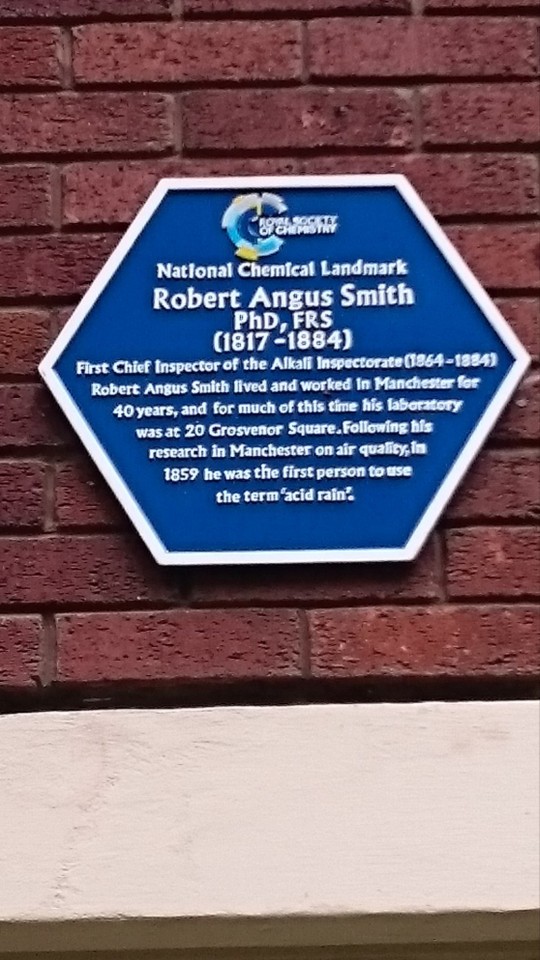
15th February 1817 saw the birth in Glasgow of Robert Angus Smith.
You may not have heard of him, or maybe you read about him in my previous post? Anyway we have all heard of acid rain, defined by National Geographic magazine thus: “Acid rain describes any form of precipitation that contains high levels of nitric and sulfuric acids. It can also occur in the form of snow, fog, and tiny bits of dry material that settle to Earth.”
The words “acid rain” were coined as long ago as 1859 by Angus Smith, who seven years earlier had made the discovery that northern cities across Britain were suffering from rainfall that contained heavy pollutants that were the result of the burning of coal that was rich in sulphur. His research found that the worst-affected city was his home town of Glasgow.
Robert Angus Smith was born in Pollokshaws the seventh son and 12th child of John Smith, originally from Ayrshire, and his wife Janet, daughter of James Thomson who owned a mill at Strathaven in Lanarkshire.
His elder brother John was a big influence on Angus’s life. John eventually became a senior teacher at Perth Academy, and was himself a scientist who would research theories on colour and light. He encouraged his younger brother to read the works of Joseph Priestley, the pioneering English chemist, and Angus Smith was greatly influenced by Priestley’s writings.
He attended Glasgow University from the age of 13, apparently to prepare for a career in the Church of Scotland ministry, but he left without graduating and then became a tutor to families, first in Scotland and then in England. In 1839 he accompanied the Bridgeman family to Germany where he remained to study under the Professor Justus Liebeg, gaining his PhD in 1841.
On returning to England he took a post at Manchester Royal Institution as assistant to Lyon Playfair, an Indian-born Scot and a scientist and politician.
Playfair passed on his own interest in the sanitation of towns and cities to Angus Smith, who left the Institution to set up in business as an analytical chemist. As concern grew about pollution, his services were in demand, and in one famous experiment he waited until a crowded room had emptied then collected the residue on windows to prove that human breath exuded not just carbon dioxide but organic matter dangerous to health.
Smith once graphically described the effects of Manchester’s polluted atmosphere, in a letter to the Manchester Guardian published on November 2, 1844.
He wrote: “Coming in from the country last week on a beautiful morning, when the air was unusually clear and fresh, I was surprised to find Manchester was enjoying the atmosphere of a dark December day… Those who would defend such evils, who would remain careless as long as any probable cause is unremoved, must surely be devoid not only of mercy, but of clear perception and of good taste. The gloominess of uncleanness is everywhere around us.”
In 1851 he began the research that would make him the “father of acid rain” as he is often known. Smith proved that sulphur compounds in the air of towns and cities were the result of burning coal and coke transported in air and rainwater, and even as the industrial revolution was bringing more and more factories into being, Smith was arguing that manufacturers should be held responsible for their pollution.
He investigated poor housing and water quality, and published numerous papers that formed the basis of the developing science of environmental chemistry. One report on the problems of pollution for the Royal Mines Commission was particularly devastating in its scientific indictment of the polluters.
Smith was called as an expert witness in a court case over factory and mine pollution and his testimony was convincing. Consequently when the British Government decided to legislate – in the Alkali Act of 1863 – to try and cut pollution from mining and manufacturing, there was really only one man to turn to as the first chief of the alkali inspectorate and thus Smith spent much of the next two decades transforming attitudes to pollution.
In 1872 Smith published his Air and Rain, the beginnings of a Chemical Climatology, in which he collected the result of his experiments. It proved how ground-breaking his work had been.
With honorary degrees from both Glasgow and Edinburgh University, Angus Smith was honoured in his own lifetime. His health declined badly in his later years and he died at at Colwyn Bay, North Wales, on May 12, 1884, being buried in the churchyard of St Paul’s, Kersal, Manchester.
He was paid a most generous tribute in the first edition of Nature magazine following his death: “For upwards of 40 years he laboured unceasingly to show how chemistry might minister to the material comfort and physical well-being of men — not in the manufacture of new compounds useful in the arts, or in the establishment of new industries – but in raising the general standard of the health of communities by checking or counteracting the evils which have followed in the train of that enormous development of the manufacturing arts which is the boast of this century.
“In his true vocation, as the chemist of sanitary science, Smith worked alone, and we have yet to find the man on whom his mantle has fallen."
12 notes
·
View notes
Text
There are ancient oral traditions, still repeated by the elders of some of the more remote islands, which provide an explanation for the Maldives' atmosphere of lost prehistoric grandeur and for its strange ruins. These traditions speak of a mysterious people called the Redin, said to have built the hawittas, who were described to me by Naseema Mohamed, a scholar at the Maldives National Institute for Linguistic and Historical Research, as:
"Very tall. They were fair-skinned, and they had brown hair, blue eyes sometimes. And they were very, very good at sailing. So this story has been around in Maldives for many, many years, and there are certain places where they say the Redin camped here, and certain places which they say here the Redin were buried. But we don't really know how old or how long ago it happened."
During his series of research visits to the Maldives, Thor Heyerdahl collected and compiled Redin legends from all parts of the archipelago. He concludes that in the memory of the islanders the Redin were 'a former people with more than ordinary human capacities':
"The Redin came long before any other Maldivians. Between them and the present population other people had also come, but none were as potent as the Redin, and there were many of them. They not only used sail but also oars, and therefore moved with great speed at sea ..."
Such notions of humans with supernatural or even god-like powers flying swiftly across the sea in their boats with sails and oars is strangely reminiscent of the imagery of the Rig Veda ... concerning the Asvins - who are several times praised for having conducted a daring rescue in the depths of the Indian Ocean:
"Yea Asvins, as a dead man leaves his riches, Tugra left Bhujyu in the cloud of waters ... Ye brought him back in animated vessels ... Bhujyu ye bore ... to the sea's farther shore, the strand of ocean ... Ye wrought that hero exploit in the ocean which giveth no support, or hold, or station, what time ye carried Bhujyu to his dwelling borne in a ship with hundred oars, O Asvins."
Thor Heyerdahl makes a case that there is real history behind the Redin myth, that it is older than the date now confirmed by radiocarbon for the construction of the hawittas - which tradition nevertheless attributes to the Redin - and that the people it refers to probably originated in north-west India, the primary setting of the Rig Veda ... [at] the great marine dockyard of the Indus-Sarasvati civilization at Lothal [north-west India] ... cowrie shells from the Maldives (Cyprea Moneta) have been excavated amongst the ruins and are to be seen in the site museum ...
— Graham Hancock, Underworld: The Mysterious Origins of Civilization, ch. 13, section The Secret of the Redin
#graham hancock#underworld#the mysterious origins of civilization#india#ancient india#hindu#hinduism#sanskrit#redin#rig veda#asvins#maldives#ancient civilizations#great deluge#antediluvian world#the great flood#flood#great flood#deluge#antediluvian#pre-flood
16 notes
·
View notes
Text
Hotels and homes destroyed, impassable roads and thousands of people cut off. This is how Acapulco, in the Mexican state of Guerrero, has been left after the passage of Hurricane Otis, the most powerful Pacific storm to make landfall on Mexican territory in the last 30 years. The cyclone, which in 12 hours went from a tropical storm to a category 5 hurricane, the highest possible classification, has left the popular tourist destination resembling a war zone with uprooted trees, debris, roofs torn off and buildings without walls. Neither the National Meteorological Service (SMN) nor local and federal authorities were able to predict the intensity of the hurricane. Scientists were also caught by surprise. The speed with which the cyclone intensified was unusual and forced Mexican authorities to issue an evacuation alert for the area just hours before Otis made landfall.
The SMN warned at 12:00 p.m. Tuesday, that the hurricane would reach Acapulco at 6:00 p.m. the following day. However, the storm arrived earlier than expected and devastated the coastal city at 12:25 a.m. Wednesday. Winds of more than 270 kilometers per hour (168 mph) hit the town and the state of Guerrero, one of the poorest in the country, destroying everything in their path. More than 500,000 people were left without electricity, internet and telephone connection in the early hours of the morning and only part of the service has so far been restored. The breakdown of communications has complicated access to the affected areas and there is still no official information on the number of victims and the amount of damage caused, although it is expected that material losses will amount to millions of dollars.
The unusual power of the hurricane has attracted the attention of the scientific community, which links the devastating power of Otis to the El Niño season, a phenomenon associated with changes in the atmosphere and the fluctuation of water temperature in the Pacific. “There is a hypothesis that it could be related to the rise in ocean temperature, which does not mean that there are more hurricanes, but it does mean that when there is one, the cyclone accelerates its formation by taking on more energy under these conditions,” explains Claudia Rojas of the Department of Process Engineering and Hydraulics of the Metropolitan Autonomous University (UAM).
There are those who point to a relationship between climate change and the strength of hurricanes, although the scientific community is still investigating the matter. “El Niño is inducing these cyclones to reach high categories. However, it is difficult to attribute the responsibility for Hurricane Otis to climate change,” says Christian Domínguez, a researcher at the Institute of Atmospheric Sciences of the National Autonomous University of Mexico (UNAM). “What is known on a global scale is that with climate change there will be fewer hurricanes in the Pacific, but they will be more intense,” he adds. “With the information we currently have, it is not so clear that the intensity has to do with climate change because there are not so many historical records, although we have not ruled it out.”
After making landfall, Otis was downgraded to a tropical storm after depositing heavy rainfall in several states in central and southern Mexico. However, the threat has not yet passed. “The risk is not only posed by the strength of the winds. There are more dangers that such a phenomenon can entail, such as landslides and the flooding of rivers and streams,” says Domínguez. In Acapulco, some 20,000 people live in areas susceptible to flooding or landslides. The hurricane season in the Pacific begins around May 15 and ends around November 30, as such Guerrero could still experience the consequences of other cyclones, says Rojas. “Research work has shown that after a prolonged drought, very intense rainfall events occur, as is the case with tropical cyclones that can reach these [high] categories.”
Otis is not the first hurricane in recent years to strengthen so rapidly. In 2015, Tropical Storm Patricia escalated to a Category 5 hurricane in 10 hours. The difference with the current phenomenon was that it did so offshore, and authorities in the states of Jalisco, Colima and Nayarit were able to evacuate 50,000 people before it made landfall. The storm, catalogued by the SMN as “extremely dangerous” and by the media as the “largest in history,” quickly lost strength after making landfall in Mexican territory thanks to the mountainous system of the Sierra Madre Occidental, which eroded the outer ring of the cyclone and prevented greater damage and devastation. Guerrero, in this case, did not have the same luck.
Acapulco International Airport, which receives millions of tourists every year, has been completely flooded and suffered serious damage to its infrastructure, forcing the suspension of all flights. The main highways are also closed, preventing communications with Mexico City. Mexican President Andrés Manuel López Obrador had ordered his Security Cabinet to go to the affected area, but on seeing the seriousness of the situation, he decided to personally supervise the rescue efforts himself. The Mexican army has initiated an emergency protocol and 37 shelters have been set up throughout the state for victims.
15 notes
·
View notes
Text


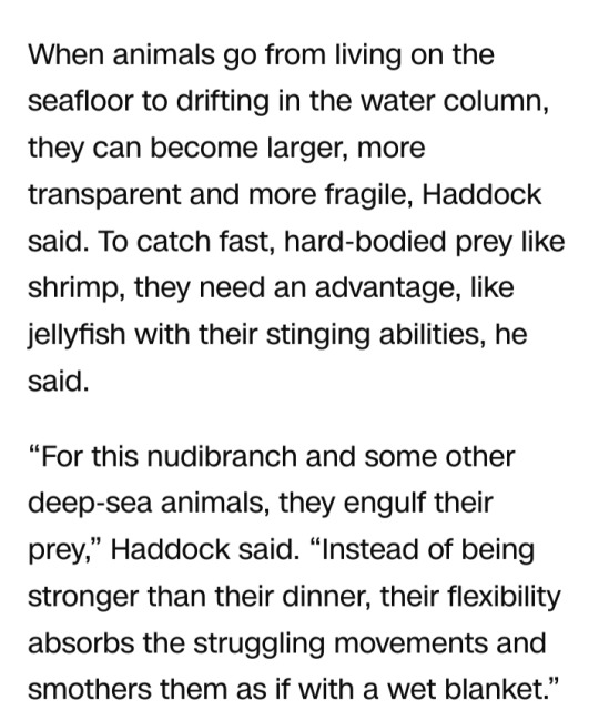
xxx
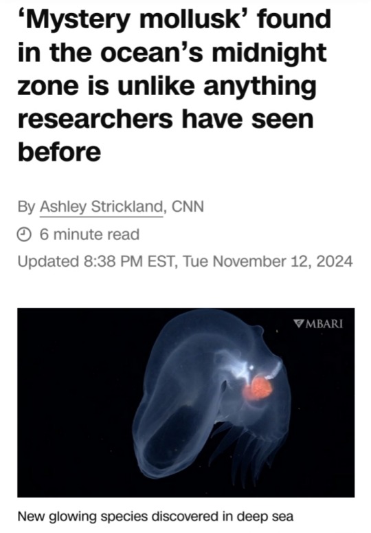
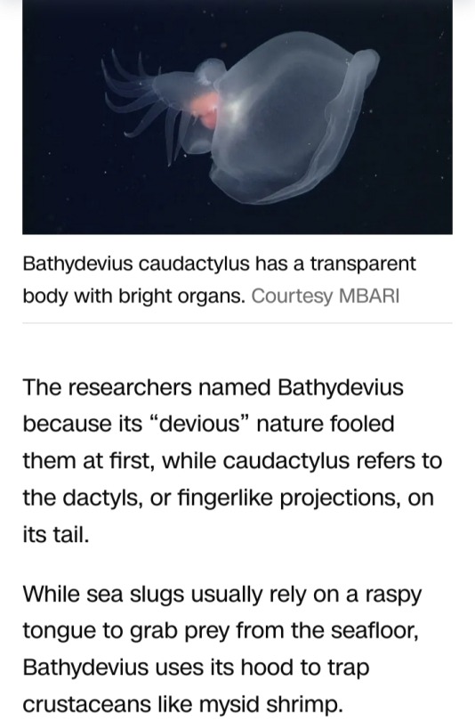
#mystery mollusk#mollusk#midnight zone#ocean#sea slug#marine animal#Bathydevius caudactylus#Monterey Bay Aquarium Research Institute#bioluminescence#gelatinous hood#deep-water dive#deep-water dive expedition#deep ocean#National Oceanic and Atmospheric Administration#nudibranch#deep water column
18 notes
·
View notes
Text
Biodiversity advocates on Wednesday called on the U.S. Environmental Protection Agency to reject a new geoengineering project spearheaded by researchers in Massachusetts that one critic said would do "nothing to solve the root causes of the climate crisis and instead puts at risk the oceans' natural capacity to absorb carbon and their role in sustaining life on Earth."
Friends of the Earth (FOE) and other groups warned that an experiment called LOC-NESS by the Woods Hole Oceanographic Institution (WHOI) carries "potentially catastrophic risks" for the Atlantic Ocean, where researchers have proposed dumping more than 60,000 gallons of sodium hydroxide near Cape Cod to test a "carbon dioxide removal approach" called Ocean Alkalinity Enhancement (OAE).
WHOI's website states that the experiment would involve the release of "nontoxic, fluorescent Rhodamine WT dye into the ocean from a research ship," with researchers tracking the dye's movement over 72 hours in order to determine whether the ocean's alkalinity could be enhanced.
If so, the scientists say, they could ultimately help to regulate atmospheric carbon.
The EPA's notice about the proposed study from last month, however, says that the project "would involve a controlled release of a sodium hydroxide solution"—which is "essentially lye, a substance known to cause chemical burns and one that must be handled with great care," according to Tom Goldtooth, co-founder and member of the board of directors of the national Climate Justice Alliance.
"Altering the chemical composition of the ocean under the guise of increasing its capacity to absorb carbon dioxide is misleading and dangerous," said Goldtooth. "An experiment centered on introducing this caustic substance into the sea should not be permitted... The geoengineering approach puts Earth's systems at risk in a faulty and false bid toward solving the climate crisis. It is what we call a false solution."
Friends of the Earth pointed out that WHOI's permit application to the EPA acknowledges that after changing the ocean's alkalinity, the researchers "have no direct way of measuring how much carbon dioxide will be removed by the experiment."
"The production of alkaline materials is extremely energy-intensive, releasing similar or even higher levels of greenhouse gasses than they remove upon being dumped into the ocean," said the group. "The researchers have declined to analyze how much carbon dioxide was released in the production, transportation, and dumping of the sodium hydroxide, making it impossible to know whether the technology even reduces greenhouse gas emissions."
#ecology#enviromentalism#us politics#cape cod#massachusetts#geoengineering#greenwashing#environmental protection agency#greenhouse gas emissions
3 notes
·
View notes
Text

Dr. Ayana Elizabeth Johnson (August 23, 1980) is a marine biologist, environmental strategist, and policy expert. Born to a teacher and an architect, She was raised in Brooklyn.
She earned a BA in Environmental Science and Public Policy from Harvard University. She earned a Ph.D. in Marine Biology from Scripps Institution of Oceanography. Her dissertation focused on the bionomics and social and economic factors of maintaining coral reefs sustainably. She was awarded an American Association of University Women Fellowship, a Switzer Environmental Fellowship, a National Science Foundation Graduate Research Fellowship, and an NSF Integrative Graduate Education and Research Traineeship Fellowship. She won the first Rare/National Geographic Solutions Search contest for the fish trap that she invented. She held a policy position in the Environmental Protection Agency and, she held a policy position in the National Oceanic and Atmospheric Administration. She went on to occupy the role of Director of Science and Solutions at the Waitt Foundation.
She led the Caribbean’s first-ever successful ocean zoning project. This zoning project resulted in the protection of the coastal waters of Barbuda.
She spearheaded the growth of this initiative, successfully instituting it in Curacao and Montserrat through partnerships. She is the founder and president of a consulting firm, Ayana Elizabeth Consulting. She founded an ocean policy think tank called Urban Ocean Lab which works to develop ocean policy solutions for coastal cities.
She was among the inaugural members of the TED Residency program and an Aspen Institute Scholar. She works as an Adjunct Professor of Environmental Studies at New York University, a National Geographic blogger, a volunteer co-director of partnerships for the March for Science, and is an independent consultant for climate policy issues and ocean conservation working with non-profits through her consulting firm. Her work has been featured in Nature magazine, The New York Times, Scientific American, and The Atlantic. In her spare time, she is a dance party organizer and jazz singer. #africanhistory365 #africanexcellence
2 notes
·
View notes
Text
Not even the Arctic Ocean is immune to the incessant growth of microplastic pollution. In a new study that analyzed sediment core samples, researchers quantified how many of the particles have been deposited since the early 1930s. As scientists have shown elsewhere, the team found that microplastic contamination in the Arctic has been growing exponentially and in lockstep with the growth of plastic production—which is now up to a trillion pounds a year, with the global amount of plastic waste projected to triple by 2060.
These researchers analyzed the seawater and sediment in the western part of the Arctic Ocean, which makes up 13 percent of its total area. But in just that region, they calculated that 210,000 metric tons of microplastic, or 463 million pounds, have accumulated in the water, sea ice, and sediment layers that have built up since the 1930s. In their study, published last week in the journal Science Advances, they cataloged 19 synthetic polymer types in three forms: fragments, fibers, and sheets. That reflects a dizzying array of microplastic sources, including fragments from broken bottles and bags and microfibers from synthetic clothing.
Overall, the team found that microplastic levels have been doubling in Arctic Ocean sediments every 23 years. That mirrors a previous study of ocean sediments off the coast of Southern California, which found concentrations to be doubling every 15 years. Other researchers have found an exponential rise in contamination in urban lake sediments.
The problem is likely to keep getting worse, lead author Seung-Kyu Kim, a marine scientist at Incheon National University, told WIRED by email. “The input of microplastics into the Arctic has increased exponentially over the past decades, with an annual increase rate of 3 percent,” Kim writes. “The mass production of plastic at an 8.4 percent annual increase—coupled with inefficient waste management systems—is projected to further increase loads of plastic entering the ocean for the next several decades, and thus plastic entering the Arctic will increase proportionally.”
The atmosphere, too, is increasingly infested with microplastics. By one calculation, the equivalent of hundreds of millions of disintegrated plastic bottles could be falling on the United States alone. A study of a peatland area in the Pyrenees found that in the 1960s, less than five atmospheric microplastics were being deposited per square meter of land each day. It’s now more like 180.
This new Arctic paper “helps to show that any increase in production is matched in the environment,” says Steve Allen, a microplastics researcher at the Ocean Frontiers Institute who did the peatland study. “And as more research into human exposure comes to light, I believe the increase will also be shown in human bodies.”
Microplastics are readily moving between different environments. A previous study found 14,000 microplastics per liter of Arctic snow, the stuff having blown in from European cities. Microplastics are also arriving in the Arctic by sea: When you wash your clothes, hundreds of thousands—or even millions—of synthetic fibers break off and flush into a wastewater treatment facility, then eventually to the ocean. Currents then transport microplastics up into the Arctic, where they swirl around and eventually settle in the sediment. Allen and other scientists reported in May that a single recycling facility might emit 3 million pounds of microplastics a year—and those were numbers for a brand-new plant that filtered its runoff water.
Interestingly, this new study found higher levels of microplastics around the retreat line of summer sea ice. This may be due to a biological highway of sorts. The algae Melosira arctica grows on the underside of Arctic sea ice, providing food for organisms like zooplankton. When that ice melts, the algae sinks to the seafloor, taking all those synthetic particles with it. “These clumps sink much more rapidly to the seafloor than other particles, within a day,” says marine biologist Melanie Bergmann of the Alfred Wegener Institute in Germany, who recently reported finding 31,000 microplastics per cubic meter of this algae in the Arctic Ocean. “This could also explain why this [sediment] study, similar to our results from earlier studies, found the highest microplastic burden in the area with high melting rates.”
Bergmann has also found that Arctic sea ice itself is loaded with 4.5 million microplastics per cubic meter. When it melts, the particles are liberated to swirl around in the water column, perhaps sinking to the seafloor. Once the sea ice freezes again, it “scavenges” microplastics from the water by collecting them into the new ice.
The cycling of microplastics through the Arctic Ocean may ultimately affect the food chain: The zooplankton that feed on Melosira arctica algae are eating the particles, and when the microplastics sink to the seafloor, bottom-dwelling creatures eat them too. Filling up on plastics, instead of actual nutrition, is a problem scientists call “food dilution.” “This could affect especially invertebrates like sea cucumbers, brittlestars, and worms that plough through and ingest these contaminated sediments all the time,” says Bergmann.
This burden on ecosystems is why environmentalists and scientists are calling for the United Nations plastics treaty, which is currently in negotiations, to include a dramatic cap on production. In March, researchers provided hints that a cap could produce quick results: They found that although ocean microplastic levels have skyrocketed over the past 20 years, they actually fluctuated between 1990 and 2005—perhaps due to the effectiveness of a 1988 international agreement that limited plastic pollution from ships.
Kim writes that the new paper is another data point in favor of production limits: “This strongly supports the urgent need of globally concerted vigorous action to substantially reduce the plastic ocean input, and thus to protect the Arctic environment.”
32 notes
·
View notes
Text
Excerpt from this story from EcoWatch:
Mexico could see record temperatures in the next two weeks, as extreme heat driven partially by El Niño blankets the country.
A lack of sufficient rainfall has left 70 percent of Mexico suffering from drought conditions, with a third experiencing severe drought, the national water commission said, as Reuters reported.
“In the next 10 to 15 days, the country will experience the highest temperatures ever recorded,” National Autonomous University of Mexico (UNAM) researchers said in a statement, as reported by Reuters.
In the coming two weeks, temperatures in Mexico City could soar as high as 95 degrees Fahrenheit, said Jorge Zavala, UNAM’s director of the Institute of Atmospheric Sciences and Climate Change.
The capital city was one of several cities in the country that recorded its hottest day earlier this month, and most residents do not have air conditioning.
Since the beginning of the hot season on March 17, extreme temperatures have killed at least 48 people, with most dying from heat stroke and dehydration, Reuters said in another report.
Hundreds of others have suffered from sunburn and other heat-related conditions, according to health ministry data.
At this time during last year’s hot season in Mexico, three heat-related deaths had been reported.
According to meteorologists, a high-pressure heat dome over northern Central America and part of the Gulf of Mexico stopped the formation of clouds, leaving Mexico and parts of the Southern United States exposed to unrelenting sunshine and scorching temperatures, The Associated Press reported.
Warm, moist air was transported northward from the equator by tropical southerly winds, adding to the rare string of hot days.
11 notes
·
View notes
Text
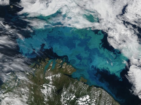
Phytoplankton bloom in the Barents Sea on August 14, 2011. This image was taken by the Moderate Resolution Imaging Spectroradiometer (MODIS) aboard the Aqua satellite. Photograph By NASA, GSFC/Jeff Schmaltz/Modis Land Rapid Response Team
Climate Change Will Shift The Oceans’ Colors
In the next century, satellites will watch as the ocean's blues and greens intensify.
— By Sarah Gibbens | July 21, 2023
The color of deep blue oceans, shallow turquoise waters, and emerald green coasts is quickly changing as the planet warms, according to new research published in the journal Nature.
Analyzing 20 years of satellite data, the study's authors found that over half the world's ocean, 56 percent, experienced a shift in color. The cause? Changes in the density and distribution of plankton. These tiny organisms contain chlorophyll, the bright green pigment that helps plants make food from sunlight.
The recent study supports a similar prediction made by a Nature Communications study published in 2019 that modeled how phytoplankton will change as oceans continue to warm.
And while the new study used satellites to detect subtle changes in color, the prior research predicted significant changes by 2100, if the world keeps warming at its current pace.
Under a “business-as-usual” scenario in which greenhouse gas emissions continue unabated, the bluest subtropical zones of the ocean will become bluer, and greener regions along the equator and poles will become greener, that study found.
More than just an oddity, the changing color is a warning sign, say the 2019 study authors, of drastic global changes that will take place in a world warmed by climate change.
How The Ocean Gets Its Color
Sunlight penetrates over 600 feet below the surface of the ocean. Everything deeper is enshrined in darkness. Above that, most water molecules are capable of absorbing all colors except blue, which is why blue is reflected out.
Organic matter that blankets the surface of the ocean, like phytoplankton, changes this color. As the ocean warms, currents become more irregular, and the layers in the water become more stratified, meaning warm regions don't mix as easily with cold regions.
There are thousands of phytoplankton species, uniquely adapted to warm or cold water. As oceans continue warming, some species may die off, some will thrive, and others will migrate to different regions.
But just looking at chlorophyll alone, however, won't tell scientists how a warming climate is altering phytoplankton. Naturally occurring events like El Niños and La Niñas can influence how much phytoplankton is concentrated in a given area
youtube
Stephanie Dutkiewicz, an author on both papers and marine ecologist at the Massachusetts Institute of Technology, said in 2019 that models used to predict future changes in color factor phytoplankton life cycles and movements into naturally occurring ocean patterns.
The 2023 study revealed that many of these predicted changes have already occurred. Using light-measuring devices aboard NASA satellites, scientists observed that over half of the world covered by ocean already showed a measurable shift in blue and green wavelengths, an approximation for the amount of chlorophyll in a given region.
What Do These Changing Colors Mean?
It's too early to say for sure what effect these changing colors will have on the environment, but scientists think more ecosystems could be dominated by smaller-sized plankton in the future, according to a press release from the National Oceanography Center in the U.K., which supported the 2023 study.
The ocean has absorbed about a third of the world's carbon emissions, and marine life like kelp, seagrass, and algae play a critical role in helping pull that carbon out of the atmosphere.
But smaller algae could reduce that climate change-fighting power.
“Phytoplankton are the base of the marine food web. Everything in the ocean requires phytoplankton to exist," Dutkiewicz told National Geographic in 2019. "The impact will be felt all the way up the food chain."
#Youtube#The National Geographic#Climate Change#Sarah Gibbens#Oceans’ Colors#Phytoplankton Species#El Niños | La Niñas#Stephanie Dutkiewicz#Massachusetts Institute of Technology#NASA#Scientists#Oceanography Center U.K. 🇬🇧
3 notes
·
View notes