#Mt. Haeckel
Explore tagged Tumblr posts
Visit Tumblr Blog
Explore Tumblr blogs with no restrictions, modern design and the best experience.
Last Seen Tumblr Blogs


Fun Fact
Tumblr was the first site to host the blog for President Barack Obama in 2011.
Text
Theodore Solomons – A Father of the JMT (Part 2)
Excerpted from Michael Hoberman, “Jews in the Wilderness”
This post follows the January 27 post that focused on the role that Theodore Solomons played in the shaping of the nation’s best-loved and most spectacular long-distance footpath, the John Muir Trail. The Pacific Crest Trailside Reader: California (2011) includes Solomons own account of the origins of the JMT, “The Beginnings of the John Muir Trail.” This particular story talks about Solommons and Bonner and their naming and exploration of the Evolution Valley and Lakes and the pass that would eventually be named for John Muir.
What Theodore Solomons experienced and found in 1895, besides eventually yielding the information that enabled Joe LeConte to find Muir Pass in 1908, merits retelling and commemoration. Well ahead of the freak July snowstorm that drove them off the side of Mount Goddard, he and his companion had already become the first recorded Sierra travelers to enter an area that, in an expression of his enthusiasm for the scientific developments of the day, Solomons decided to call the Evolution Basin. Two days out from Jackass Meadows, they found themselves ascending a steep tributary gorge of the South Fork San Joaquin that, as Solomons would write in his trail report of 1896, contained more water than its narrow volume seemed capable of holding. “Swelled by the fast-melting snows of its high sources,��� Solomons explained, “the stream hurled itself with torrential force over a series of falls and cascades the most striking and magnificent I have yet encountered in the Sierra.” At the top of the thousand-foot climb along the waterfalls lay a several-mile-long stretch of pristine and forest-fringed meadow whose beauty rivaled that of Yosemite’s famous Tuolumne Valley. Solomons called it “one of the fairest paradises of the nowhere unlovely western slope of the Sierra.” He marveled at the fact that its “difficulty of approach” had kept it from being overrun by the hundreds of thousands of grazing sheep that John Muir, a decade earlier, had famously referred to as “hoofed locusts.”
At the southeastern edge of what we now know as Evolution Meadow, Solomons and Bonner encountered and ascended another gorge. As he first described it in his 1896 report, Solomons referred to it generically as the Middle Fork of the San Joaquin; later, he named it Evolution Creek. As the two men continued to climb the gorge in a southeasterly direction, they saw a “peaked and pinnacled wall” to their immediate south whose looming elevation above them (they were already well above 10,000 feet) ranged between 1,500 and 3,000 feet. Those imposing summits, he wrote, deserved to be thought of as “beautiful monuments rather than mountain peaks.” In the days following his and Bonner’s failed attempt to surmount the Goddard Divide, Solomons named each of them after his scientific and scholarly heroes: Charles Darwin, Thomas Huxley, Herbert Spencer, Alfred Wallace, Ernst Haeckel, and the philosopher John Fiske. These men, as Solomons wrote in his 1940 retrospective (included in the 2011 Pacific Crest Trailside Reader: California), had been so “at-one in their devotion to the sublime in Nature” that only these massive rock towers could suffice to monumentalize their legacy.
I sat on my unsaddled bronco facing east and gazing in utter fascination at the most beautiful and the most mysterious sight I had ever seen.
At the base of these heights lay an additional, albeit less intimidating wonder. Hikers all up and down the John Muir Trail still speak of this “fine sheet of water,” as Solomons described it, in reverential tones, whether or not they have heard of the explorer who named it Evolution Lake. These days, every evening from late June to early September its northern end is dotted with multicolored tents. As many as two dozen backpackers bask on its rocky shore, hydrating their meals with water that they’ve fetched out of its frigid depth.
Solomons knew that Evolution Lake was a place of signal importance and also of contradictory implications. “Nowhere more generous is the recompense that awaits the wearied traveler” to its shores, he wrote, highlighting its refugelike qualities. At the same time, he also intuited a profound connection between its apparent isolation and the extreme density that characterized the population centers of his home state of California. “Such is the birthplace of the San Joaquin,” he wrote, “the origin of that river which turns a hundred mills, irrigates a million acres of grain, fruit, and vine, and which imparts fertility and beauty to the largest and richest of California’s valleys.”

Snow Tunnel, Enchanted Gorge, Sierra Nevada photographs / Taken by Theodore Seixas Solomons
At the end of the day on which they’d visited Evolution Lake, Solomons and Bonner camped at the foot of the peak that he’d just named Mount Huxley. They didn’t realize it at the time, but this particular campsite lay within 2 miles of the pass they were seeking. Indeed, as Solomons slept, he dreamed that his “task was fully done.”
Was he also imagining the backpackers who would eventually converge there? In his dream, “A well-marked trail led from the distant Yosemite past the long lake, up the snow-basin, and over the divide to the King’s River.” It was one thing to have been a teenager fantasizing from the lowland safety of his uncle’s pasture about an imaginary trail passing along the crest of the Sierras’ “flashing teeth.” It was another to picture the future trail at a moment when he was several days into a journey along the mountains’ spine, at such an enormous remove from the slightest reminder of civilization. Solomons “hope[d] that his dream was prophetic.” He knew that “the way was clear” and that “only the trail wait[ed] to be built.”
The snowstorm came the following day, as Solomons and Bonner climbed and then descended Mount Goddard in their attempt to locate the pass he’d just dreamed about. The gorge in which they sought and found shelter and warmth over the course of the next several days would prove to be a dead end of sorts, but few dead ends in the world can possibly have been so densely packed with scenic features. Traveling headlong down the south side of the mountain, they entered an area that remains trailless to this day. Solomons called it the Enchanted Gorge. In the words of a hiker who visited it in 1996, it still qualifies as “one of the most remote canyons in the Sierra Nevada.”
The Enchanted Gorge, as Solomons first described it, “was guarded by a nearly frozen lake, whose sheer ice-smoothed walls arose on either side, up and up, seemingly into the very sky, their crowns two sharp black peaks of most majestic form.” He called the peaks Scylla and Charybdis. After gingerly making their way around the edge of the lake, the travelers followed a snow-choked “road” through the gorge, descending “as though into the bowels of the earth,” all the while glancing upward at “black, glinting, [and] weird” walls whose 2,000-foot summits they could barely see. Solomons captured the otherworldliness of the gorge in the photographs he took while there. Two of his most striking images, “Rotunda in the Enchanted Gorge” and “Snow Tunnel in the Enchanted Gorge,” relay the beauty and desolation of the place in stark detail—the thick cover of snow, the jagged rocks, the indifferent sky, and nary a sign of vegetation even in the far distance, let alone of animal or human presence of any kind.
For all of its wonders, the journey into the Enchanted Gorge was not bringing them any closer to a crossing of the Goddard Divide, but they weren’t aware of that fact yet. On their southwestern trajectory out of the wilderness, Solomons and Bonner entered another deep valley formed by the Middle Fork of the Kings River called the Tehipite (fittingly, today’s Theodore Solomons Trail passes through that area). They exited the wilderness at Simpson Meadow on July 28, having logged 200 miles of hiking through places that very few, if any, other human beings, had ever seen.

The Rotunda, Enchanted Gorge, Sierra Nevada photographs / Taken by Theodore Seixas Solomons
In 1896 Solomons made two trips in the region north of the Goddard Divide. The second of the two, during which he successfully led an official Geological Survey party through the territory around mounts Lyell and Ritter and the Minarets that he had first visited and mapped in 1892, would prove to be his final outing in the Sierras for several decades to come, and also the last time he would be either making or following his own path through the mountains.
The most rugged phase of his mountaineering and exploration career lay behind him, however, and his active contributions to the development of the John Muir Trail had come to an end. In the deliberations that took place between its official commissioning in 1915 and the completion of its final portion in 1938, Solomons weighed in freely but commanded little authority.
Epilogue
John Muir’s reputation has come under renewed scrutiny owing to his alleged ties to a prominent eugenicist and his numerous disparaging comments regarding Chinese immigrants and American Indians. It is an appropriate time to revisit the mountains’ cultural significance and the trail’s namesake’s history. In 2018 a movement to rename the John Muir Trail the Nüümü Poyo, or “People’s Road,” arose among certain advocates for tribal rights who wished to draw attention to the Sierras’ Native American heritage. The Kern Kaweah chapter of the Sierra Club drafted a refutation of this proposal, albeit in as culturally sensitive a manner as they could muster. The report gave perfunctory attention to Solomons’ and other Sierra explorers’ roles in helping to create the trail in order to make its wider case in favor of honoring precedent. Why rename the trail, the authors of the report asked, when it was already, by definition, a memorial—“a human-constructed asset”—and not a natural feature like a mountain or a lake?
#Theodore Solomons#John Muir Trail Evolution Valley#Evoluntion Lake#Muir Pass#Enchanted Gorge#Mt. Huxley#Mt. Darwin#Goddard Divide#Mt. Spencer#Mt. Wallace#Mt. Fiske#Mt. Haeckel
0 notes
Text
Donkey Peak from Lake Sabrina, 2022 Sierra Challenge Day 6

Donkey Peak is an unofficially named peak located within Inyo National Forest. This name was suggested most likely because it stands above Donkey Lakes. I chose this peak per the suggestion of Bob Burd. He was looking at Donkey Peak closely on his way back from Dawkins Peak the previous summer and he thought it looked interesting. Per his recollection, the summit is comprised of large, difficult looking granite blocks. Andy Smatko describes a class 3 scramble from the south in his “Mountaineer’s Guide to the High Sierra.” I also needed an easy day outing with The Citadel, the hardest day of the challenge, planned for the following day. This was the peak I was least looking forward to in the 2022 Sierra Challenge, however it ended up being a great little peak, and even created a little bit of controversy following the outing.
I woke up in my hotel in Bridgeport and commenced the lonely drive towards Lake Sabrina. I was a little early so I went to the restroom at the end of the road, and had a good laugh from the sign I found inside.

I made it back in time for the trailhead photo and a few moments later we were off.

As we plied the trail I noticed a beacon of light up ahead. Could this be Donkey Peak?

After a couple miles we came to one of the funnier signs in all of the Sierra.

We look a left towards Donkey Lake, but a short distance later I realized that we were off my pre-drawn GPS track. We missed an unsigned spur trail that climbed towards Baboon Lakes, so we left the trail and did a short cross country stint to get back on track. Everyone else had their own ideas of how to best climb the peak, and I soon found myself alone again. I was most confident in my route, and I think the results showed, as I was among the first few people to reach the summit. I couldn't help but notice the unnamed Peak 11,800 to the north.

It was an easy day, so we had a full turnout on the summit.


To the southwest was Picture Peak.

To the west was Mt Darwin.

To the northwest were the Piute Crags.

I spotted Mike near the top of the striking Peak 11,800 to the north.

We spent a lot of time snacking and socializing on the summit. Mike made the summit photo which was an impressive feat. It took him only a few minutes to traverse from Peak 11,800 to our location.

Emma showed up a few minutes after the group photo and mounted the summit block.

The peak itself was really not that impressive, however, and we were soon looking for bonus peaks. The unnamed peak a half mile to the south was higher and more prominent, so most of the group continued along the ridge. Prior to the hike, I informed the participants that this would qualify for bonus peak credit, even though it appeared to lack the necessary 262 ft of prominence to qualify.

It was a fun scramble, and ended up being a better peak than the one we had come from. The peak stood above Baboon Lakes, so we suggested the name Baboon Peak. Down below was Moonlight Lake.

The views were much of the same. To the south were Sunset Peak and Point Powell. The key col also looked lower than I expected. Perhaps this peak has enough prominence after all.

Clyde Spires and Mt Haeckel stood behind Picture Peak.

Mt Darwin dominated the region.

Lake Sabrina rested to the north.

Mike claimed to have spotted a Huffy bike along the ridge. That must have been some sort of effort to bring a bike all the way up there. There was a 1971 register on the summit.

The second group to sign in were Barbara Lilley, Andy Smatko and Bill Schuler. I expected to find Smatko's name, since the peak is reference in his totebook, “Moutaineer’s Guide to the High Sierra.”

Then two years later there was an R.J. Secor signature claiming, “Andy goofed!” What could this mean?

The gears in my brain started churning. It was raining when Smatko climbed what he thought was Donkey Peak, so he may have been disoriented. Secor refers to some other summit along the ridge. Meanwhile, Peak 11,800 looked a lot more interesting than the Donkey Peak which we had all just summited a few minutes prior. Could the true location of Donkey Peak be incorrectly documented?

I wasn’t sure. The others already started trickling over to their next bonus peak, Sunset Peak.


I thought about it for a while. I finally decided that I should go back and check out Peak 11,800. I also wanted to find this Huffy bike. Sean King, Rob Houghton and Keith Hamrick agreed to join me. I exchanged greetings with Iris on my way back.

Sadly I did not find any bicycle. We traversed on ledges underneath the original suspect for Donkey Peak, also referred to as Peak 12,000+. From there we tried to stay on top of the ridge, but brush blocked the route in some places.

The brush cleared for sandy slopes, then we had some route finding through several large boulders as we neared the high point. A couple class 3 moves took us to the base of a milk bottle. Now this was a peak! Sean climbed first and quickly found himself on the top of the summit pinnacle.

We all watched nervously as Sean downclimbed the sloping feature.

I went next. A crack and some friction allowed me to get halfway up the thing. Then I had to grab the sides of the rock to get enough confidence to climb up the remaining distance.


This felt more like the "old school" class 3 that I had expected prior to the outing.

I had to be very careful climbing back down, but this was done without any issues.


Keith and Rob went next. We were all happy to have gone to this alternate point, as the scramble was very thrilling.

This felt like the real Donkey Peak to me, and the others who climbed it felt the same way. To get back down, we descended the eastern slope which was a loose mess.

We ended up splitting into two groups to mitigate the rockfall danger.

Once back on the trail we all went our separate ways. Rob met his wife and they hiked together to Baboon Lakes. Keith ran off ahead. I initially stayed with Sean, but his ankle was giving him problems, so I soon left him. On my way back, I kept staring at Peak 11,800, thinking to myself that it must have been the real Donkey Peak.

If my assumptions are correct, then I am the only person in the 2022 Sierra Challenge to have climbed all 10 challenge peaks. However, I have to give full challenge peak credit to all those who visited Peak 12,000+, since I am the one who posted the location and drew the map. Meanwhile, I believe some credit should be given to those who go the extra length to investigate all possible summit locations, especially those in which ambiguity lies. Whenever there is a doubt as to the true location of a peak, the meticulous and scrupulous mountaineer will climb to both summit locations. Maybe I am the winner of the yellow jersey in an alternate universe.
Also, I feel it is noteworthy to mention that Ron Hudson, at 77 years old, became the oldest participant to summit a challenge peak. Karen Anderson, at 68 years old, became the oldest woman to summit a challenge peak. Kudos!
Official Summary:
22 participants joined today’s outing to the unofficially named Donkey Peak. All participants made it to Donkey Peak as marked on LoJ. All except a few continued a short distance along the ridge towards the unofficially named Baboon Peak, which contained an Andy Smatko, Bill Schuler and Barbara Lilley register. Most of the participants continued on towards Sunset Peak, which apparently had a spicy class 4 summit block.
I had a different idea. I backtracked with a few participants towards Point 11818 at the north end of the ridge. We had some suspicions that this was the real Donkey Peak which is referenced in Andy Smatko's book, "A Mountainer's Guide to the High Sierra." While Bob Burd claims that the LoJ summit is 100% Donkey Peak, those who climbed Point 11818 feel otherwise for several reasons. Point 11818: -more closely matches the Andy Smatko route description. -has more prominence than the LoJ Donkey Peak -is closer to Donkey Lake -is clearly visible from the lower reaches of the Lake Sabrina basin -has a remarkable summit block.
Further investigation is needed. Since I drew the map (doh!), everyone who completed either possible Donkey Peak will receive credit towards the challenge peak.
My email to Bob following the challenge:
I bought Smatko’s book just so I could get to the bottom of this. I also came away unsatisfied. The elevation (Peak 12,000+) and location (2 NNW of Mt Thompson) clearly point to the original point as being the location of Donkey Peak. However the description clearly favors the alternate Peak 11,800.
>> This peak is an easy climb from the west and south except near the summit.
If you recall, Peak 12000+ cannot be climbed from the west, at least easily. It looked like a cliff dropping off the summit area down into the Middle Fork Basin. In reality, the peak is an easy climb from the south, east and north.
>> The summit rocks are easy class 3 from the south.
Could you even call Peak 12000+ class 3? Sure there is probably one tiny little move, but to me the peak felt more like class 2. If you look at Peak 11,800, there is an old school class 3 summit block that is clearly best approached from the south. I believe that Smatko meant to call Peak 11800 Donkey Peak, but there was an error in transcribing the exact location of the peak after the fact. Also, this wasn’t a Smatko first ascent, so I don’t think he is simply padding his stats by claiming a random bump on the ridge. I think this debate will remain open until you climb Peak 11,800. Then you might move over to my camp. Whenever there is a doubt, it’s best to climb both peaks
.
0 notes
Photo

Interstellar gas and dust clouds setting over Mt. Haeckel and nearby peaks at Lake Sabrina, California [OC][2048x3072] via /r/EarthPorn https://ift.tt/37z6mAy
0 notes
Text
Inventions and Discoveries for Banking & SSC CGL Exam
Scientific Inventions and Discoveries
When you look at the question papers of SSC CHSL, SSC CGL, SSC MTS, IBPS PO, IBPS Clerk, IBPS SO, IPPB Sc. I, LIC AAO, etc. you may find a lot of questions related to Inventions and Discoveries. Questions based on Inventions and Discoveries form a part of the General Awareness section of many Govt. and Bank exams. Therefore, you need to be well prepared for the topic of Famous People Who Made Scientific Discoveries for Banking & SSC CGL Exam. Moreover, if you are interested in taking any Online Mock Tests then you can click on the link to begin your preparation for any other Government Exams. Here’s a list of Top Inventions and Discoveries by Scientists - A to Z List for Banking & SSC CGL Exam. We have divided the entire list into Physics, Chemistry, Biology, Computers, Space Science etc. You can also download this article as PDF for further reference. Inventions/Discoveries Name of the Scientist/Person Adding Machine Pascal Aeroplane Wright brothers Air Brake George Westinghouse Air Pump Otto von Guericke Airship (rigid) G. Ferdinand Von Zeppelin Aniline Dyes Hoffman Antiseptic Surgery Lord Joseph Lister Arc Lamp C. F. Brush Archimedean Screw Archimedies Atom Neils Bohr Atomic Number Mosley Atomic Physics Enrico Fermi Atomic Structure Bohr and Rutherford Atomic Theory Dalton Automatic gearbox Hermann Fottinger Automobile Daimler Automobiles using gasoline Karl Benz Avogadro’s Hypothesis Avogadro Bacteriology Robert Koch Bacteriophage Max Delbruck Bakelite Leo H Baekeland Balloon Jacques and Joseph Montgolfier Ball-Point Pen John J. Loud Barometer Evangelista Torricelli Behaviorism B. F. Skinner Beri – Beri Eijkman Bicycle Kirkpatrick Macmillan Bicycle Tyre J.B. Dunlop Bifocal Lens Benjamin Franklin Binomial Nomenclature Carl Linnaeus Biogenetic Principle Ernst Haeckel Bismuth Valentine Blood Circulation Harvey Blood Groups Karl Landsteiner Bomb Edward Teller Boson S.N.Bose Boyle’s law Boyle Braille Louis Braille Breaking up the Nucleus of an atom Rutherford Calculating machine Pascal Camera George Eastman Carburetor Gottlieb Daimler Carburettor Gottlieb Daimler Cash register William Burroughs Cell Doctrine Rudolf Virchow Celluloid A.Parker Cement Joseph Aspdin Cenema A.L. and J.L. Lumiere Centrigrade scale A. Celsius Chemical Structure August Kekule Chemotherapy Paul Ehrlich Child Development Jean Piaget Chloroform James Harrison and James Young Simpson Cholera Bacillus Robert Koch Chromosomal Theory of Heredity Thomas Hunt Morgan Chronometer John Harrison Cine camera Friese-Greene Cinematograph Thomas Alva Edison Cinematography Thomas Alva Edison Circulation of the Blood William Harvey Classical Field Theory Michael Faraday Clock (machanical) Hsing and Ling-Tsan Clock (pendulum) C. Hugyens Coloured Photography Lippman Computer Charles Babbage Continental Drift Alfred Wegener Cosmic Rays R.A.Millikan Crescograph J.C.Bose Crystal Dynamics C.V.Raman Cyclotron Lawrence D.D.T. Dr.Paul Muller Deciphering the genetic code Dr.Hargobiad Khorana Deuterium (Heavy Water) H.C.Urey Diesel Engine Rudolf Diesel Diesel Oil Engine Rudolf Diesel Difference engine Charles Babbage Electrons J.J.Thomson Laws of Planetary Motion Kepler North Pole Robert Peary (1909) Solar System Copernicus (1540) South Pole Amundson (1912) Specific Gravity Archimedes West Indies Columbus (1492) Drinker’s Chamber of Iron Lung Dr.Philip Drinker Dynamical theory of Heat Lord Kelvin Dynamite Alfred B. Nobel Dynamo Michael Faraday Effect of Pressure on trough bodies Meghnad Saha Eightfold Way Murray Gell-Mann Electric Battery Alessandro Volta Electric Flat Iron H. W. Seeley Electric Furnace William Siemens Electric Generator Michael Faraday electric guitar Adolph Rickenbacker Electric iron H.W. Seeley Electric Lamp Thomas Alva Edison Electric Measurement Gauss Electric Motor (AC) Nikola Tesla Electric razor Jacob Schick Electrical Waves Heitz Electricity Faraday Electromagnet William Sturgeon Electromagnetic Field James Clerk Maxwell Electromagnetic Theory Maxwell Electron Joseph J. Thomson Electron Theory Bohr Electronic Computer Dr. Alan M. Turing Elevator Elisha G. Otis Energy of the Sun Hans Bethe Equal sign (=)? Robert Recorde Ethology Konrad Lorenz Eugenics Francis Galton Evolution Charles Darwin Evolution (theory) Charles Darwin Evolutionary Theory Ernst Mayr Fahrenheit Scale Fahrenheit Film & Photographic goods Kodak Film (with sound) Dr. Lee de Forest Foundations of Biology Jean Baptiste Lamarck Foundations of Mathematics Euclid Founding of Modern Physiology Claude Bernard Founding of Psychology Wilhelm Wundt Fountain Pen Lewis E. Waterman Fundamental Laws of Electric Attraction Coulomb Galvanometer Andre-Marie Ampere Gas lighting William Murdoch Gasoline engine Karl Benz Genetic Code Frederick Sanger Geometry Euclid Germ Theory of Disease Louis Pasteur Glider Sir George Caley Gramophone Thomas Alva Edison Gun powder Rogei Bacon Heavens William Herschel Heavy Hydrogen Urey Helicopter Broquett Heliocentric Universe Nicolaus Copernicus Helium Gas Lockyer Homoeopathy Hahnemann Hovercraft Christopher Cockerell Human Sexuality Alfred Kinsey Hydrogen Cavendish Hydrophobia Louis Pasteur I.Q. Test Alfred Binet In Number Theory Ramanujam Incandescent Bulb Edison Induction Coil Rohm Korff Induction of Electric Current Faraday Insulin F.Banting Intelligence test Binet Internal Combustion Engine Otto Jeans Levi Strauss Jet Engine Sir Frank Whittle Jet Propulsion Frank Whittle Kala-azar Fever U.N.Brahmachari Kaleidoscope David Brewster Laboratory Gas Burner Robert Wilhelm Von Bunsen Laughing Gas Priestley Law of Electrolysis Faraday Law of gases Gay Lussac Laws of Electrical Resistance Ohm Laws of Gravitation Newton Laws of Heredity Gregory Mandel Laws of Inheritance Gregor Mendel Laws of Motion Newton Laws of Multiple Proportion Dalton Laws of Natural Selections Darwin Life Boat Henry Great Head Lift E.G. Otis Lift (Elevators) Otis Lightning Conductor Benjamin Franklin Line of demarcation (ship) Plimsoll Linotype Mergenthaler Liquid Oxygen Dewar Locomotive Richard Trevithick Logarithmic Tables John Napier Logarithms John Napier Machine Gun Dr. Richard Gatling Malarial Parasite Ronald Ross Match (safety) J.E. Lurdstrom Mathematical Astro Physics Chandrasekhar Mathematical Genius Carl Gauss (Karl Friedrich Gauss) Mauve dye Perkin Measurement of Electrical Energy Joule, James Prescoft Mechanical Equivalent of Heat Joules Mercury Thermometer Fahrenheit Meson Hideki Yakawa Microphone Johann Phillip Reis, Alexander Graham Bell, Elisha Gray, Amos E. Dolbear, and Thomas Edison Microscopic Anatomy Marcello Malpighi Modern Anthropology Franz Boas Modern Astronomy Arthur Eddington Modern Computer John von Neumann Modern Geology Charles Lyell Modern Physiology William Bayliss Modern Synthesis Theodosius Dobzhansky Modern Telescope Edwin Hubble Molecular Biology Francis Crick Molecular Scattering of light in fluid Ramanathan Montessori Method Maria Montessori Motion of the Planets Johannes Kepler Motor Car (petrol) Karl Butler Movie Projector Thomas Alva Edison Neon Gas Ramsay, Travers Neon-lamp G. Claude Neurophysiology Charles Sherrington Neutron Chadwick New Anatomy Andreas Vesalius New Astronomy Tycho Brahe New Science Galileo Galilei Newtonian Mechanics Pierre Simon de Laplace Newtonian Revolution Isaac Newton Nuclear Fission Otto Hahn, Bohr and Fermi Nylon Dr. Wallace H. Carothers Nylon Plastic Carothers Organic Chemistry Emil Fischer Origin of Species Charles Darwin Oxygen Priestly Paints Shalimar Paper clip Johann Vaaler Parking meter Carlton Mcgee Penicillin Alexander Fleming Periodic Law Mendeleef Periodic Table of Elements Dmitri Mendeleev Pharmacology Gertrude Belle Elion Phonograph Edison Photograph Dauguerre Photography (paper) W.H. Fox Tablot Phototherapy N.R.Finsen Pneumatic Tyres John Boyd Dunlop Positive Electrons Anderson Power Loom Edmund Cartwright Powerloom Cartwright Principle for lever (S.P.Gravity) Archimedes Printing for the Blind Braille Printing Press Johannes Gutenberg Psycho-analysis Dr.Sigmund Freud Psychology of the Unconscious Sigmund Freud Quanta Max Planck Quantum Cosmology Stephen Hawking Quantum Electrodynamics Richard Feynman Quantum Mechanics Max Born Quantum Theory Werner Heisenberg Quantum Theory Max plank Raazor (safety) K.G. Gillete Rabies Vaccine Louis Pasteur Radar Dr. A.H. Taylor and L.C. Young Radio G. Marconi Radio transmitter Alexanderson Radioactive Dating Willard Libby Radioactivity Marie Curie Radio-activity of Uranium Henry Becquerel Radium Madame Curie Railway Engine Stephenson Raincoat Charles Macintosh Raman effect C.V.Raman Rare Gas Cavandish Rayon American Viscose Co. Razor (electric) Col. J. Schick Refrigerator James Harrison, Alexander Catlin Replacing human heart Christian Barnard Revolution in Chemistry Antoine Laurent Lavoisier Revolver Samuel Colt Rise of German Science Hermann von Helmholtz rubber (vulcanized) Charles Goodyear Rubber (waterproof) Charles Macintosh Safety lamp Sir Humphrey Davy Safety Pin William Hurst Safety Razor King C. Gillette Salk Vaccine Salk Saxophone Antoine Joseph Sax Scientific astronomy Hippalus Scientific Thinking Lucretius Scooter G. Bradshaw Seismograph Roberts Mallet Sewing Machine Thomas Saint Sextant Hadley Ship (steam) J.C. Perier Ship (turbine) Sir Charles Parsons Shorthand Sir Isaac Pitman Sociobiology Edward O. Wilson Soviet Genetics Trofim Lysenko Space flying Braun, Dr.Wernher Von Spectroscope Bunsen Spectroscopy Gustav Kirchhoff Spinning frame Sir Richard Arkwight Spinning jenny James Hargreaves Stainless Steel Harry Brearley Steam boat Fulton Steam Engine James Watt Steam engine (condenser) James Watt Steam engine (piston) Thomas Newcome Steam Turbine Parsons Steel Melting Process Bessemer Steel production Henry Bessemer Stethoscope Dr. William Stokes, Rene Laennec Stress Concept Hans Selye Structural Anthropology Claude Levi-Strauss Structure of DNA James Watson Structure of the Atom Ernest Rutherford Submarine David Bushnell Sulpha Drugs Domagk Superconductivity Heike Kamerlingh Symbiosis Theory Lynn Margulis Symbol (x)? William Oughtred T.N.T. llly Brandt Talkies Lee-de-Frost Tank Sir Ernest Swington Telegraph Samuel Morse Telegraphic Code Samuel Morse Telephone Sir Alexander Graham Bell Telescope Galileo Television Baird Television (mechanical) John Logie Baird Tempo of Evolution George Gaylord Simpson Terylene J. Whinfield and H. Dickson The long playing microgroove record Peter Goldmark Theory of conditioned reflex Pavlov Theory of Evolution Darwin Theory of Relativity Einstein Theory of the Atom John Dalton Thermodynamics Ludwig Boltzmann Thermometer Galileo Gallei Thermos Flasks Dewar Tractor J. Froelich Transformer Michael Faraday Transistor Bardeen, Shockley, Brattain Typewriter C. Sholes Uranium fusion Oho Hahn Uranus (Planet) Herschel William Vaccination Edward Jenner Valve of radio Sir J.A. Fleming Vitamins Hopkins and Funk Vitamin A Elmer V. McCollum and M. Davis Vitamin B Elmer V. McCollum Vitamin B1 Casimir Funk Vitamin B2 D. T. Smith, E. G. Hendrick Vitamin Niacin Conrad Elvehjem Vitamin Folic acid Lucy Wills Vitamin B6 Paul Gyorgy Vitamin C James Lind Vitamin D Edward Mellanby Vitamin E Herbert Evans and Katherine Bishop Vulcanised Rubber Charles Goodyear Washing Soda Lablanc Watch A.L. Breguet Waterproof Rubber Charles Macintosh Wave Mechanics Erwin Schrodinger Wave Theory of Light Christiaan Huygens Wave/Particle Duality Louis Victor de Broglie Wireless Communication Oliver Lodge Wireless Telegraphy Marcony World Wide Web and Hypertext Markup Language Tim Berners Lee X – Rays Roentgen X-ray Wilhelm Reontgen X-ray Crystallography Max von Laue zerox machine Chester Carlson Zip fastener W. L. Judson Zipper B. F. Goodrich We hope that you have gained sufficient information about Inventions and Discoveries for Banking & SSC CGL Exams. If you know more about this topic that you think the article hasn’t included, then comment below. Read the full article
#FamousScientistsAndTheirDiscoveriesList#InventionsAndDiscoveriesForBanking&SscCglExam#InventionsAndDiscoveriesInPhysics#InventionsAndDiscoveriesPdf#InventionsAndDiscoveriesQuiz#ListOfDiscoveriesAndDiscoverers#ListOfFamousDiscoveries#ListOfIndianInventionsAndDiscoveries#ListOfInventionsAndInventors#ScientificInventionsAndDiscoveriesThatChangedTheWorld#TopInventionsAndDiscoveriesByScientists-AToZListFamousPeopleWhoMadeScientificDiscoveries
0 notes
Text
Mt Goode (13,085 ft) from South Lake

It was day 6 of the 2021 Sierra Challenge. After climbing Mt Haeckel and Mt Wallace the day before, I was pretty tired but felt like I had enough in me to squeeze out an easy peak. The challengers were climbing Panorama Point out of South Lake, so Mt Goode felt like the perfect fit. I was saving this peak for when I needed an easy day, and that day finally came. I was a little slow out of bed in the morning and had to scream at the others to wait for me as I jogged out of my car to pose for the group picture.

Soon after everyone except the fishermen departed. I went back to my car to put on my shoes and then I needed five more minutes to use the restroom. Once I had fully collected myself, I started off up the familiar trail. I took the short cut in an effort to make up as much ground as possible.

I caught up to Emma and Megan shortly after reconnecting with the main trail. They were the only people I would greet until reaching the summit. Chocolate Peak emerged through the pines above.

Mt Goode came into view as I reached Long Lake.

The eastern side of the peak was basking in the morning sun. Fish rings and a slight breeze obfuscated the summit reflection.

I spotted a lone hiker on the trail ahead of me, but I would never catch whoever it was.

Mt Agassiz stood above Bishop Pass directly ahead.

I left the trail between Saddlerock Lake and Bishop Lake.

I followed a light use trail and was surprised to find a cabin nestled between some pines.

The sun began to rise above the Inconsolable Range as I crossed the South Fork of Bishop Creek.

There was a mushroom tucked between some rocks that I was unable to identify.

Frosted Buckwheat covered the mountain slopes.

I climbed a section of steep talus and sand until I reached an open bowl above.

The next section was a very dull, class 2 slog. I could hear someone above me, but I could not see anyone.

Finally I spotted someone atop the summit. Would they still be there by the time I arrived?


As I climbed the final boulders I was greeted by Sean King and Zee. I reached the summit a little after 9am, which meant it took me only 3 hours to reach the top. To the southwest was the Black Divide.

To the west were Mt Goddard, Mt Johnson and Mt Gilbert.

To the north were Mt Humphreys, Mt Tom and Hurd Peak.

To the east were Cloudripper and Picture Puzzle.

To the southeast were Mt Agassiz and the Palisades.

To the south were Columbine Peak, Giraud Peak and the challenge peak.

Directly beneath me was an incredibly cool sequence of moraines.

We chatted on top for a while, savoring our easy peak. Sean was undecided about continuing towards the challenge peak a short distance to the south. I urged him on, which gave him the final motivation to actually do it. Meanwhile Zee was content to hike back with me. The descent was quick and seemed even faster with good conversation. Sometimes I feel down thinking about all the problems that we are facing as a society, but with a younger generation of great kids like Sean King and Zee, I have hope for the future. I got back to the car around noon, then drove down to Bishop to meet Asaka for lunch. That afternoon was the Sierra Challenge cook-off, so Asaka and I got to work on our dish. We made loco moco sliders, and since no one else really prepared anything beyond grabbing a rotisserie chicken or chips from Safeway, Asaka and I won the cook-off. Our prizes were limited edition Sierra Challenge shirts with a typo. It felt good to finally get first place for once.


The next day we chose to drive up Mazourka Peak since I needed a rest from hiking. Initially the plan was to simply drive from Bishop to Independence, however Leif was still sleeping in his car seat when we arrived, so we decided to keep driving up Mazourka Canyon. Things were going pretty well until I got an alert saying that my tire pressure was low. I had a critical flat in one of my tires, so I stopped the car to change to my spare. My tires were rated as "all terrain" and had less than 10k miles on them. What a joke. I went to take off the lug nuts but they were screwed on too tight. It was a high pressure situation with the baby in the car, since we had no service and were miles away from the nearest paved road. After a stressful sequence of events, I finally was able to get the tire off and switch to the spare. We were only a couple of miles away from the peak, so we continued driving up the road, stopping a quarter mile from the summit to walk a little bit.

We had Leif walk up the last section of the road to the top.

Leif got distracted several times with all the cool rocks around.

He finally made it to the summit under his own power. Mommy and Daddy were very proud.

We drove back to Independence where I found another one of my tires had a slow leak. This "rest" day turned into a huge affair that left me worn out. I had planned to climb Mt Pinchot from Armstrong Canyon the following day, but I could no longer trust my tires to make that 4WD road. With my plans shot, I had to think of another plan, but things ended up working out in the end.
0 notes
Text
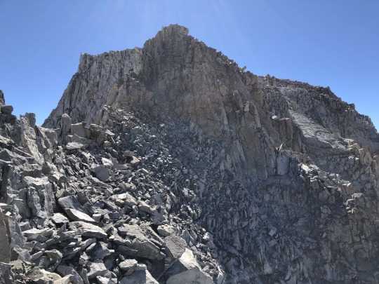
Mt Haeckel (13,418 ft) & Mt Wallace (13,383 ft) from Lake Sabrina

It was day 5 of the 2021 Sierra Challenge as well as my birthday. The group was heading out of Lake Sabrina, so I felt the best way to celebrate was by climbing two SPS peaks; Mt Haeckel and Mt Wallace. When it comes to multiple SPS peaks in a day’s outing, there are few in the High Sierra that are easier to combine than these two. I woke up in my dark motel and snuck out trying my best not to wake the baby. After a peaceful drive, I arrived at the Sabrina Lake Trailhead where the other participants were gathering. The midweek numbers were down when compared to the weekends. I showed up for the group photo at 6am.

Then we were off. The trail starts off as an old road which eventually morphs into a proper trail. We had a good laugh watching AJ run across the dam trying to catch up with the group. He must have thought that the starting point for the day was at the end of the road near the boat ramp. I stuck with the core of the group at a good pace but things almost ended before they got started. A hot spot on my heel had started to develop, and the pain was so sharp that I was worried that I’d have to call it. I frantically asked around if anyone had a remedy, and thankfully AJ had some Moleskine that he kindly shared with me. Applying this treatment put me back behind the pack, but I was able to catch up with some of the others after several minutes. My rest day had apparently paid dividends.

Over time the main group splintered and smaller groups began to form. I settled in with Gong, Mason and a young newcomer named Matthew Rosen, and we discussed a potpourri of topics. We couldn't have asked for better weather that fine day.


We passed by several lakes, tarns and creeks as we followed the general watercourse of the Middle Fork of Big Pine Creek. I tried to convince some of the others to join me for Mt Haeckel and Mt Wallace, but they were all set on climbing the challenge peak.

After about 5.5 miles, I turned left while the others continued straight towards Midnight Lake.

Mt Powell and Picture Peak came into view.

The trail skirted around Sailor Lake through grassy meadows and over granite slabs.


Rather than continue towards Moonlight Lake or Hungry Packer Lake, I instead aimed for the ridge dividing their respective drainages.

I stayed atop this long gradual ridge as it led towards the base of Picture Peak. Down below to my right was Hungry Packer Lake.

I could hear the others talking somewhere across the drainage, but I could not see them.

Picture Peak stood ahead of me.


The ridge had some minor ups and downs, but for the most part did a good job of gaining elevation at a moderate grade.

Further ahead was Echo Lake, but I would not pay it a visit on this day. Instead I would stay high above the lake, contouring beneath the southern side of Picture Peak.


Sections of this contouring was slow and tedious. There were sections of sand and loose rock, and my slow pace became somewhat frustrating. The route I took was a little too high, and I ended up having to descend down towards the inlet of an unnamed tarn for easier hiking.

Once at the bottom of the gully, I followed the stream for the next quarter mile.

Rockfringe Willowherb

Alpine Sorrel

I was thankful for this creek since I now had a reliable place to drink unfiltered water.

As I approached the creek's source, Mt Haeckel and Mt Wallace appeared above.


The tarn I found between the peaks was fed by a permanent snowfield and was larger than I expected.

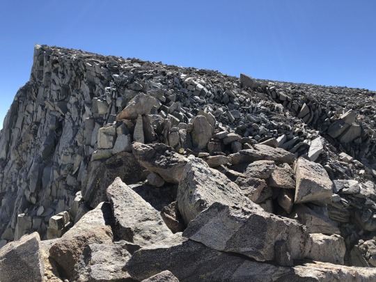
From here I was a little intimidated because it didn't look like there was an easy way to climb Mt Haeckel. I didn't remember reading anything about the route being harder than class 3, so I approached the heap of near vertical granite rocks expecting to spot a weakness as I got closer. Mt Wallace stood defiantly to my south.

Sure enough, a route slowly began to appear as I got closer. A series of granite ramps, sandy sections and large steps took me in a diagonal direction towards the ridge along the crest.

Rather than continue along an obviously easy route towards the ridge, I decided to spice things up and climb a series of class 4 steps in a more direct manner than necessary. My reasoning was that it was my birthday, and I wanted to make the climb more interesting.


The rock quality was superb, and after climbing a couple hundred feet in this manner, I decided to quit while I was ahead and connect back with the standard route.

What followed was some really fun class 3 scrambling. After some enjoyable route finding, I eventually found myself on the summit of Mt Haeckel. To the northwest was Mt Darwin. The challenge peak was one of the minor bumps along the ridge in between.

To the west were Mt McGee and Emerald Peak.

To the southwest were Mt Fiske, Mt Huxley and Mt Goddard. Out of nowhere, a big rockfall started on the northern slopes of Mt Fiske. It was very loud, but hard to spot at first. Eventually I noticed a small plume of dust emanating from the mountainside. I don't think this was human caused, rather a normal instance of erosion.

To the south was Mt Wallace. I've heard that the ridgeline traverse between the two is a treat.

To the east were Picture Peak, Mt Powell, Mt Thompson and Cloudripper.

To the northeast was Lake Sabrina.

Evolution Valley

I opened the summit register to find its contents completely soaked. I left it out in the sun to dry, but when I was ready to go to the next peak, it was still wet. I left the book unsigned, turning my focus now to Mt Wallace.

I found a really easy class 2-3 descent path along the ridge. I then began traversing along the east side of this ridge.


I simply took my time and looked carefully for the path of least resistance. At a gap in the ridge, I had a good view of Lake 12021 and the withering Mt Fiske Glacier.

The final climb of Mt Wallace loomed ahead.

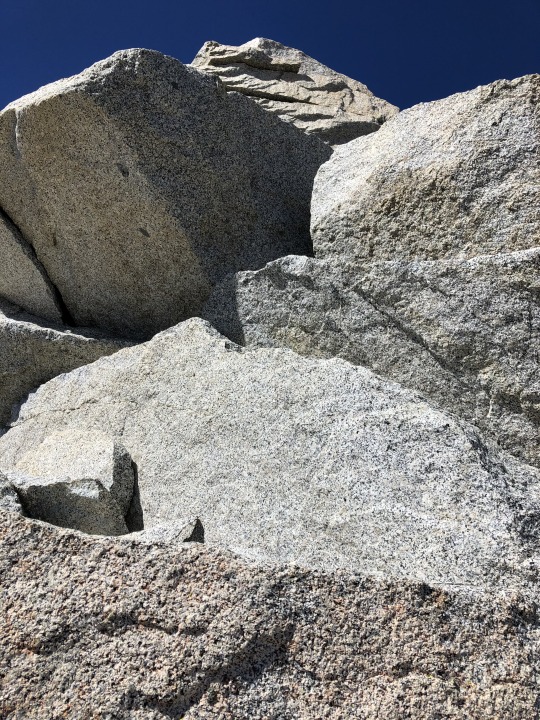
One can find the easiest route slightly to the east of the ridge, but I instead took a direct line along the top of the ridge. With solid rock and a plethora of holds, this also proved to be very fun.


At the very top I was surprised to find a challenging summit block. The exposure wasn't that high, but this boulder problem took a little bit of finesse. With some primitive techniques, I was able to sit atop the summit block.

I had to be careful taking pictures. To the south were Clyde Spires and Black Giant.

To the east were Echo Lake, Mt Powell, Mt Thompson and the Palisades.

To the northeast were Lake Sabrina and Picture Peak.

To the northwest were Mt Haeckel and Mt Darwin.

To the west was Mt McGee.

To the southwest were Mt Fiske and Mt Goddard.

Climbing off the summit block was a little tricky. I found the register below and a very interesting entry from Vitaliy a.k.a. the Mountain Gangsta.

As I prepared to head back down, I spotted Clemente on Mt Haeckel. He was already beginning his way to Mt Wallace.

I chose a route that led directly towards the outlet of the tarn below. My route was mostly class 2 but was very loose. I started several small rock slides as I stumbled my way down. Every now and then I would look up to follow Clemente's progress along the ridge. To my north were two emblem peaks; Mt Darwin and Mt Humphreys.

I was relieved to get back down onto more stable terrain. I filled up one of my water bottles at a small waterfall at the creek below.

I walked around the lower tarn before beginning the loose sidehilling around the south side of Picture Peak. I considered swimming here, but decided a swim would be better appreciated after some more trail miles.


Tiling's Monkeyflower

Hungry Packer Lake

Moonlight Lake

I continued down the granite ridge and then picked up the trail at Sailor Lake.


I passed Iris and the fishermen as I wound through the various bodies of water that dot this drainage.

Picture Peak

I finally stopped for my swim at Blue Lake. From here I only had 3 miles to go.


Mt Emerson & Piute Crags

Lake Sabrina

The last mile was a little warm, but the finish line was in view.

I found Bob and a few others waiting at the cars. They seemed ready to enjoy some beers while waiting for the others. I instead chose to hurry back to my family who were waiting in Bishop. Later that evening, several of the Sierra Challenge participants met me for Mexican food. Asaka bought me a cake, capping off a great birthday.

0 notes
Text
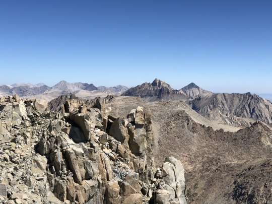
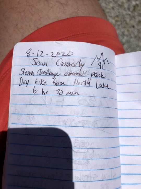
Mt Darwin (13,831 ft), A Day Hike via Lamarck Col
My main goal for the 2020 Sierra Challenge was to day hike Mt Darwin. Day 6 had the group heading towards the Socialite, which shared an approach with the standard route to Mt Darwin over Lamarck Col. I had wanted to climb this emblem peak for over a decade, but was discouraged by the class 5 summit block rating. Many of my hiking companions and acquaintances assured me that I would have no problem with the summit block, and even went so far to call it class 3-4. My interest was further amplified after a quasi failed attempt earlier in July. I ran our group into the ground on a backpacking trip to Evolution Basin and Mt Goddard, and we didn’t have enough juice to finish off our trip with a Mt Darwin summit. On our hike out, I considered returning a month later during the challenge, and studied the route from a distance. I also read through many detailed trip reports, but in the end I was still unsure if I would be capable of completing such a strenuous day. A month later I found myself in the best physical condition I had ever been in. I participated in days 2-4 of the challenge, allowing me to acclimate and get my legs underneath me. I then rested on day 5 to hydrate and recover. Even after all of my preparation, doubts lingered. I told Asaka that I could possibly be out for over 20 hours, and may even face the reality of having to bivouac. I had a little panic attack the night before, but I eventually found peace while watching the sunset before bed. The next morning, I woke up fresh. I made it to the trailhead by 4am, parked at the hikers parking lot, then followed a headlamp up the road ahead of me. This turned out to be Iris. I had studied Matt Yaussi’s video of their day hike to Mt Darwin, and was greatly concerned because it took them over 17 hours back in 2017. They had both been faster hikers in than me in the past, so I expect to take even longer.
youtube
She reassured me that they were extremely slow that day, and spent a lot of time waiting for others who were doing a day hike to Mt Goddard. We waited at the bathroom at the end of the road and soon we were joined by Mason, Tom Becht and Tom Grundy as well. We stuck together maintaining a solid pace up the dark trail. I settled in right in the middle of the pack. I remember the stars looking extra bright that night. Chatting with the group was enough to keep me distracted as we made our way up the steep trail. Last time I was here I was struggling with a heavy pack in the heat of the day. Now I felt like a leaf floating up the mountain with a breeze. After several miles, it dawned upon me that I was keeping up with hikers whom I once viewed as superhuman. I was seeing the fruits of my labor and a sense of euphoria filled my being. It was a beautiful morning and my body was feeling great. Lamarck Col came into view sooner than I expected, a familiar sight from not loo long ago.

A young trail running couple, not part of the challenge, showed up out of nowhere. They said they were on their way to Scylla, a very formidable objective. They climbed some talus slopes to the left of the pass. I considered saying something, but I figured they were probably off to tag Lamarck Col Peak as a bonus peak. They ended up missing the col by accident, and at the end of the day they didn’t make it all the way to Scylla. There was a little less snow than the month prior, and we were able to avoid it altogether by staying on the rocks to the left. To my surprise, I had made it to the pass in under 3 hours. I had budgeted 4 hours to reach the pass, and while I wasn’t that tired, I took a short break to soak in the beauty.

The others dropped down towards Darwin Bench while I waited for Bob Burd to catch up down below. I asked if he knew of anyone heading to Mt Darwin. Christine was signed up for Mt Darwin, but she broke her collar bone going over Haeckel Col earlier that week. Bob cheerfully replied that Zee and his friends were going for Mt Darwin, and the young trio showed up shortly after. Fearing that I would be much slower than them, I got a head start and subsequently descended the other side of the col. Bob and I chatted for a while, but slowly separated as we took our own routes down towards Darwin Lakes.

When viewing the map, it appears easiest to sidehill as much as possible to avoid unnecessary elevation loss. However, I found it was easier to simply drop down to just below the 12,000 ft contour. Sidehilling was loose and tedious while a more direct route was across solid granite slabs and grassy ramps.

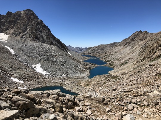
After dropping over a thousand feet, I regained what was just lost by heading towards the toe of the much receded Darwin Glacier. I stopped at a very nice tarn here to fill up water. I looked around for Zee and his friends but they were nowhere in sight. I expected them to have caught me by now. After a break, I continued up the moraine, avoiding the icy glacier altogether, wondering if I could get to the the start of the scramble without stopping to put on crampons.

I was wise enough to aim for the notch ~100 meters to the left of the lowest point in the ridge. There was one lingering patch of ice that blocked the route.


While short, the patch of snow was extremely steep and icy. It was just enough to get someone in trouble. I sat down on a rock and put on my crampons.


I crossed the patch with relative ease and just two minutes after putting them on I was already removing my crampons. Still no sign of Zee and his friends; strange.

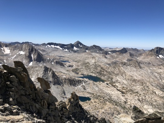
Now began the start of the class 3. There was a lot of loose rock and dirt, and the exact route wasn’t apparent to me. I think I initially went too far left, and found myself on some steep dirt. I got off this as soon as I could across a very loose horizontal pitch. This was hard class 3, and one should be very careful here. I was encouraged though because while I was dealing with these challenges, my elevation was getting higher and higher. I was relieved when I made the notch. Across Evolution Basin was Mt Goddard.

Back to the northwest was Mt Mendel.

I was a little on edge after that sketchy section. The ridge ahead of me didn’t look simple, but I expected it to be relatively straightforward.
What I found was some more class 3. I was very rhythmic and methodical, placing focus on each move. I took in the views of Evolution Basin and Mt McGee below. The Socialite and The Hermit stood behind Evolution Lake.

I knew I was getting close when I was of equal height with Mt Mendel, which stands just a hundred feet lower than Mt Darwin.

I was encouraged when I attained the summit plateau, but remained humble knowing that the exposed summit block lay ahead.
As I approached the edge of the plateau, I secretly hoped that a earthquake or simply erosion had knocked over the summit block. I crossed the rounded plateau and sure enough the summit block was still there in all its glory. I knew exactly what to do. I had to drop from the plateau to the small notch in between where I stood and the summit block. Form there I would descend a dirt chute to the left, then reclimb another chute up the eastern side of the summit block.

Rather than take a break and give myself time to think about it, I went straight for it. I dropped my backpack, only taking my phone and a couple pieces of webbing just in case I needed to hang onto something.

I dropped down to the notch, then further down the chute to the left. There was a lot of steep dirt but I felt in control. So far, so good.

I started climbing up the final chute. There was a large chockstone in the way. This stumped me for a second, but I found my way up and over by stemming around it. On to the next challenge.

The next few moves were class 3. The exposure was not so bad, and the climbing was pretty easy. Just a little more to go.
Finally, the last move. While exposed, there are extremely good holds and the rock is solid.

I heaved myself up with little difficulty. I would call it class 4. To the northeast was Mt Tom Ross. I didn’t know it at the time, but Sean King spotted me on Mt Darwin from atop this peak.

To the southeast were Cloudripper, Mt Agassiz, Mt Winchell and North Palisade.

To the south were Mt Haeckel and Mt Fiske.

To the southwest was Mt Goddard.

To the west were Mt McGee and Mt Henry. My red backpack remained on the plateau.

To the northwest was the tip of Mt Mendel.

To the north were Mt Humphreys and Mt Tom.
youtube
I was very satisfied with my time of 6 hours and 20 minutes. I had a solid chance to make it back down several hours before I expected.
I had lunch waiting in my backpack so I figured I would take my extended rest once on more solid ground. I took in the exposure all round me. The one move of class 4 was easy to downclimb with solid holds.

I even felt comfortable enough to follow the Evolution Ridge a short distance to see the famous traverse first hand.


Standing over here also gave me a different perspective of the summit block.

The technically hardest part of the whole climb was the chockstone. I dropped back down to the notch and made it back to my backpack. I had my lunch then began my way back towards the west ridge. I was still a little concerned with the down climb back to the Darwin Glacier, and I wanted to put this behind me. I took parting glances at the summit block on my retreat.


My eyes traveled down the length of Evolution Valley to the hinterlands in the distance.

I thought about climbing Mt Mendel, but I still had to reclimb Lamarck Col, so I played it conservatively, figuring I could climb this on a future challenge.

Now I turned my focus to the class 3 downclimb. Slow and steady wins the race, I thought to myself.

Descending from the notch took a lot of focus. As I approached the Darwin Glacier, I spotted several people beneath me. It was Zee and his friends.

I did my best to not kick any rocks down on top of them, which was a difficult task that I was barely able to pull off. I was surprised to see them so far behind. Zee told me that they took a wrong route. They all made it across the icy section with no crampons, which was most likely easier now that the sun had time to soften it slightly. Zee asked how much further he had to go, and wondered if he could still make the summit. It was still before noon and I figured he could make it in an hour, so I encouraged him to continue. I warned them that I was scared to death that they would inadvertently kick rocks down onto me and I advised them to be extremely careful. To their credit, not even a pebble fell. I learned later that night that while his friends stopped short, Zee made it to the summit.

I crossed the sliver of glacier without crampons by kicking steps into the hard snow. The talus rock field beneath the glacier was extremely loose and tedious. I took a long rest at the tarn, basking in my glory.

I knew reclimbing Lamarck Col would be tough, but I still had some energy left. I took my time to hydrate, then headed back towards the Darwin Lakes.


I followed a route similar to my ascent route. Again, I dropped low towards the Darwin Lakes, but not all the way. I picked a gentle route up sandy patches and granite ramps.
I started free styling in Spanish to pass the time. I was surprisingly good at it. As I got higher I started singing some of my favorite reggaetón songs. I looked down and noticed a lone figure gaining on me. He must have enjoyed the concert. I met this individual at the col. He was a Canadian named Sayer and he was on his return from Mt Darwin as well. He failed to reach the summit via an alternate route, saying that the loose rock and steep dirt sections sketched him out.

I had service here and let Asaka know that I was ahead of schedule. Sayer was willing to accompany me on the hike down and I was happy to have company. I saw another lone hiker heading towards Lamarck Col Peak. I wondered if this was Sean King, since I just received his text message from earlier saying that he could see me on the summit of Mt Darwin from Mt Tom Ross. I considered this bonus peak myself, but I had started to miss Asaka and Leif, and I wanted to get back as soon as possible.

Sayer and I chatted all the way down to Lower Lamarck Lake. I remember this section being much easier than what I experienced back in July. Cooler weather and a lighter pack made a world of difference.

I stopped to take a swim at the outlet of Lower Lamarck Lake. Sayer continued on and I promised to stop by his campsite on my way out. As I swam, I was accompanied by a Swede in a speedo. Now refreshed, I continued the remaining distance towards North Lake. Sean King caught me with one mile to go, and we hiked out together comparing our achievements. He filled the stat sheet by climbing 5 peaks around Lamarck Col. I found a reserve of energy and jogged out to the trailhead at the very end. I finished the day hike of Mt Darwin in exactly 12 hours and 30 minutes. I drove back down to Bishop to pick up my family, then returned to North Lake where we cooked dinner and drank beer with Jim and Bob Burd, Sean and Scott King, Evan Rasmussen, Sayer and his girlfriend. It would be a late night for some of the other challengers. Most of the hikers still had not returned by the time I left for my motel in the dark. My main goal for the Sierra Challenge was a complete success, and I earned another rest day in Bishop.
0 notes