#Dún Aonghasa
Explore tagged Tumblr posts
Photo
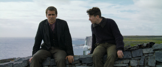
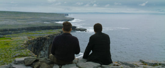

The Banshees of Inisherin Martin McDonagh. 2022
Cliff Dún Aonghasa, Inishmore, Aran Islands, Co. Galway, H91 YT20, Ireland See in map
See in imdb
#martin mcdonagh#the banshees of inisherin#colin farrell#barry keoghan#dún aonghasa#county galway#ireland#inis#movie#cinema#film#location#google maps#street view#aran islands#inishmore#2022
97 notes
·
View notes
Text
Dún Aonghasa | Co Galway
The view from the summit of the fort is most impressive and solemn: the desolate-looking fields…fall away to the golden crescent of Kilmurvey strand, and rise up the opposite hill…to the old lighthouse near Dun Oghil. Eastwards runs the long range of steep, dark headlands, and deep bays, rarely unsheeted by high-leaping spray… The limits of the view on clear days reach from the giant peaks of…

View On WordPress
#Aran Islands#Dún Aonghasa#Galway#History#History of Ireland#Inishmore#Ireland#Irish History#Irish Mythology
30 notes
·
View notes
Text

Dún Aonghasa, Aran Islands, Ireland.
13 notes
·
View notes
Text
21/08/2015


これからイニシュモア島へ🚢
とにかく酔う!と定評のある船です(苦笑)。噂通り、外海に出た途端に縦揺れ横揺れが激しすぎます…。衰弱して船の中でぐったり。 私の相席はイタリア人グループの添乗員さんで、ずっとPC入力していました。年配の男性ですが、何でこんなにスーツの着こなしがカッコいいんだろうと思ってしまい��した。
そして不謹慎な話ですが、 私「今何時ですか?」 イタリア人「eleven hour」 私「は?」 11時間ですか…? ほらほらって腕時計を見せてくれたのはちょうど午前11時。
帰国後に知りましたが、イタリア語は時計・時刻絡みの用語が1つでまとまっているらしく、「time」「hour」「o'clock」など使い分けが苦手傾向にあるそうです。 アイルランドの公用語はアイルランド語と英語なので、私がBroken Englishを話しても向こうが言いたいことを察してくれるという大変有り難い国でもあります。そして、イタリア人添乗員さんが堂々と間違えた英語を使っても、通じてしまうのを思うと私も堂々と間違えて英語を使っていいんだと根拠の無い自信がついた瞬間でもありました笑

イニシュモア島に上陸です!

海老のカクテルサラダ🦐


Dun Aengus
大西洋の外に向かう強風にあおられて、毎年観光客の死者が絶えないという、噂の場所です。 日本人観光客も毎年1人落ちて亡くなっているそうです。最近はどうなんでしょうか…?

自己責任・匍匐前進で命懸けの記念撮影です。


帰りの船を待っていると「コンニチハ」口撃で、ミラノから来たというイケメンくんにナンパされました。 アイルランドなんてアジア人は来ないエリアに日本人がいたから声をかけたそうです。 因みに彼は『日本人・韓国人・中国人の区別はつく』と言っていました笑 そんなイケメンナンパくんは美人の彼女と同伴。ふと彼女の顔を見たら鬼の形相でこちらを見るではありませんか👹 彼女の機嫌がよくなったのは帰りの船が別ということが分かり、別れる瞬間でした…(苦笑)
#備忘録#photography#reminder#Ireland#Dun Aengus#Aran Islands#oileáin Árann#Dún Aonghasa#Aranmore#Árainn Mhór#風と石の国#Galway#コンニチハ口撃#ミラノから来たイケメンナンパくん
0 notes
Text

Dún Aonghasa II, Inishmor, Aran Islands, County Galway, 2013.
A drystone fortress facing the open sea on the largest of the Aran Islands, the oldest part of the ruins date from about 1100 BCE. This bronze age/iron age fortress is evidence of an impressive amount of labor in the pre-literate era.
#archaeology#fortress#stone#iron age#bronze age#inishmor#aran islands#county galway#ireland#2013#photographers on tumblr
#archaeology#fortress#stone#iron age#bronze age#inishmor#aran islands#county galway#ireland#2013#photographers on tumblr
10 notes
·
View notes
Note
Top five places you've visited (not necessarily looking for anything fancy, you could take in a vacation kinda way, or in a my favorite bagel shop, park bench, etc way
This was hard!
Castlerigg stone circle - I love stone circles and this one is my favourite. It's usually a bit drizzly and invariably overrun with sheep. You go up a muddy hill and you can't see much, then all of a sudden there's the stone circle, and a horseshoe of mountains laid out around you.
Dún Aonghasa - this is an Iron Age hill fort on Inis Mór, off the west coast of Ireland. Half of it has fallen into the sea, so now it faces a sheer (unfenced!) cliff edge. It's spectacular. The Aran Islands are full of hill forts but Dún Aonghasa is the best. OK I could fill this entirely with prehistoric sites but that's probably enough.
Cefalù, Sicily - I think, in a crowded field, my favourite place I've ever been to on holiday. Just the perfect Italian coastal city: food, sights, sun, sea, sand...
That one amazing crepe place I found by accident in Paris and will never be able to find again - kind of self explanatory! The crepes were so good. The place was somewhere in central Paris. I have no idea where and I probably wouldn't recognise it again if I passed it.
Gruissan, France - this was the accidental destination of the first holiday my now-husband and I ever went on together. There were train strikes and we ended up hitchhiking with a carload of teenagers. We swam in the sea while French dogwalkers went by in coats and woolly hats. It was great.
3 notes
·
View notes
Text


DID 💢 YOU 👊 KNOW ⁉️ there are DAISIES GROWING between the stones of the ruins of the prehistoric fort Dún Aonghasa on the Aran island of Ireland??? ‼️‼️‼️
5 notes
·
View notes
Photo

Dún Aengus (Dún Aonghasa) è il più celebre dei forti in pietra preistorici presenti sulle Isole Aran, Contea di Galway (agosto 2005). #aldohistoryproject #irlanda #manyyearsfromnow #nature #happiness (presso Isole Aran) https://www.instagram.com/p/CpoHgZbtjkTDB7KM55u26GtGDHdR5hNMOx2Ef80/?igshid=NGJjMDIxMWI=
2 notes
·
View notes
Text
Poll na bPéist or the Wormhole, rectangular shaped pool, south of Dún Aonghasa


did this happen

10K notes
·
View notes
Text
Woche 4 - Teil 2
Die Fahrt nach Inis Mór
Am Sonntag hatte ich meine langersehnte Fahrt zu einer der Aran Inseln, Inis Mór. Die Aran Inseln liegen in der Grafschaft Galway und bestehen aus Inis Mór, Inis Meáin und Inis Oírr. Sie sind ein Naturwahrzeichen des Galway Bays und werden generell bei jedem Galwaybesuch empfohlen. Die Hinfahrt begann 11:45 und dauert ungefähr 40 min.

Die Aran Islands sind für ihre Steinmauern sowie kostbare Schafswolle bekannt
Die Ankunft
Nach der Ankunft auf Inis Mór hatten meine Gruppe und ich die Entscheidung zwischen einer Fahrradtour oder einer Bustour. Wir lehnten Fahrradfahren kategorisch ab, da Olga kein Fahrrad fahren konnte. Die Bustour gab uns ein herzlicher Mann namens Michael. Er zeigte uns im Schnelldurchlauf die schönsten Aussichtspunkte der Insel. Auch erzählte er etwas zu der Geschichte.


Links: Weg zur Festung Dún Aonghasa
Rechts: Landstraße
Oben auf der Festung Dún Aonghasa
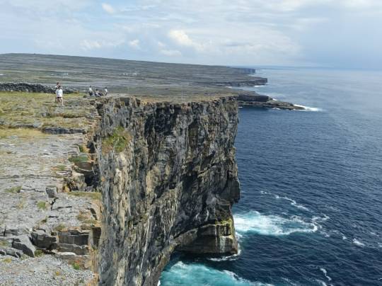

Links : Die Klippen von Inis Mór
Rechts: Entfernter Blick auf die Festung
Die Insel Inis Mór beherbergt die älteste Steinfestung Irlands. Diese heißt Dún Aonghasa, steht auf dem höchsten Punkt der Insel und ist halbkreisförmig. Von dem Punkt aus kann man die Klippen der Steilküste sehen. Dún Aonghasa wurde laut Michael ungefähr in der Bronzezeit von den Kelten erbaut. Ich habe die erhobene Aussicht sehr genossen und habe trotz der mühevollen Wanderung nach oben viel Spaß gehabt.
Ende der Tour und der Gesamteindruck
Michael hat uns später ein paar andere schöne Orte gezeigt und auch seinen Lieblingsstrand. Der verlassene Strand erinnerte mich an eine surreale Szene aus einem viktorianischen Schauerroman. Meine Gruppe und ich verstanden den Reiz, den dieser Ort für Michael ausstrahlen musste. Eva meinte auch, dass der Strand sie enorm zum Schreiben inspirierte.

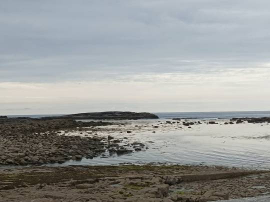
Links: Altes Kirchengemäuer mit Friedhof
Rechts: Verlassener Steinstrand, abseits von allem Tourismus
Michael führte uns auch zu seinem Pferd, um ihm kurz Trinken zu geben. Er erklärte auch warum die Steinmauern auf den Weideflächen in erster Linie errichtet wurden. Als die ersten Siedler*innen auf die Aran Inseln ankamen, soll das Land fast nur aus Felsen und Steinen bestanden haben, um aber sesshaft zu werden, trugen sie die Steine ab und zerkleinerten diese.

Die Weideflächen besitzen Steinmauern, um das grasende Vieh von anderen zu trennen und das Weidegras fair aufzuteilen. Alle können die Wiesen nutzen.
Dann verwendeten sie diese für Gemäuer, um die Erde freizuräumen. Zusätzlich haben sie von den Stränden Seetang und Sand gesammelt und diese auf die freien Felder verteilt, um diese fruchtbar zu machen. Später haben die Siedler*innen Kartoffeln und Getreide angebaut. Das erkläre auch das heutige Aussehen der Insel.
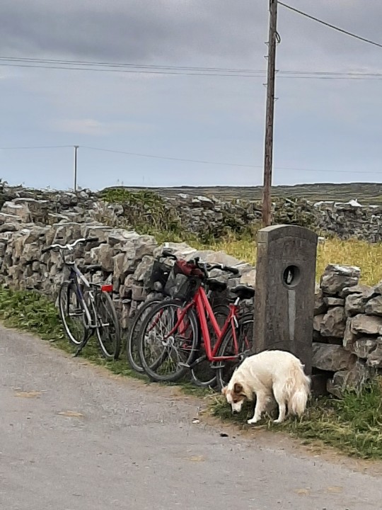
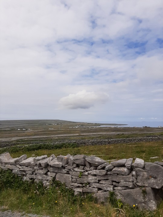
Links: Irischer Hachiko, der im Ort gerne herumstreunert. Sein Besitzer musste ihn leider zurücklassen und seitdem ist er eher menschenscheu.
Rechts: Drehort von Banshees of Inisherin
Nach dem Geschichtsunterricht bedeutete uns der Tourguide uns zu verabschieden, da die letzte Fähre bald fortging. Wir waren ungefähr um 18:30 wieder in Galway.
Inis Mór hat mich mit seiner malerischen Natur sehr beeindruckt. Ich kam mir bei dem Besuch wie in einem Gemälde vor. Am meisten habe mich über die schlafenden Kühe und grasenden Esel gefreut, die man beim Vorbeifahren erspäht hat. Ich mochte Michaels Lieblingsstrand am meisten, gefolgt von der Steinfestung Dún Aonghasa. Ich bin froh den Ausflug gemacht zu haben und würde gerne zu den Cliffs of Moher noch fahren.
1 note
·
View note
Text


Some pics of Dún Aonghasa on the Aran island of Inishmore in Galway bay. The fort is estimated to be over 3100 years old. The unbroken winds off the Atlantic nearly toppled me over as I made my way up the stone path. It wasn’t raining, but it might as well have been with the wind pushing so much fog around. It made for quite the ferry ride over! I’ve been in worse boat conditions comparatively, outside of Boston harbor in a 17 foot open motorboat, but the ferry was a good 50 feet at least so definitely the actual roughest seas I’ve been in. I loved it but I might have been the only one. Everyone in my group was like are you really gonna hike all the way up in this weather? It seems sillier to me to have flown 3000 miles, driven for 2 hours and taken a 45 minute ferry to not walk up there even though it’s a little wet?
0 notes
Text

This is Dún Aonghasa, a 3000 year old example of a fortification known as a promontory fort, which are primarily found in Ireland, the British Isles, and Brittany. They’re characterised by the use of steep cliffs that act as natural defences against attack.
humans really went off with building on precipitous rock faces
24K notes
·
View notes
Text
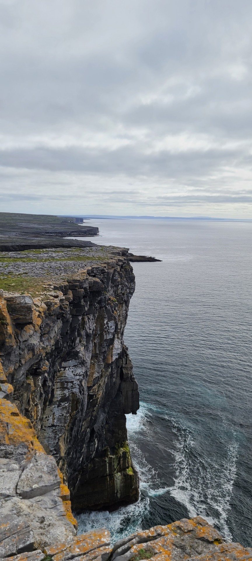
The cliffs near Dún Aonghasa, Inis Mór, Aran Islands, Galway, Ireland
#aran islands#aran cliffs#forest core#nature core#cottage core#nature#Atlantic#wild atlantic way#dún aonghasa#gay pagan#gay mystic#gay magic#gay witch#queer mystic#queer pagan#queer witch#pagan#mysticism#paganism#Ireland#prechristian ireland#adventurecore
126 notes
·
View notes
Text
Dún Aonghasa, Inishmor, Aran Islands, County Galway, 2013.

A drystone fortress facing the open sea on the largest of the Aran Islands, the oldest part of the ruins date from about 1100 BCE. This bronze age/iron age fortress is evidence of an impressive amount of labor in the pre-literate era.
#archaeology#fortress#stone#iron age#bronze age#inishmor#aran islands#county galway#ireland#2013#photographers on tumblr
10 notes
·
View notes
Text
Dún Aonghasa | Co Galway
Dún Aonghasa | Co Galway
The view from the summit of the fort is most impressive and solemn: the desolate-looking fields…fall away to the golden crescent of Kilmurvey strand, and rise up the opposite hill…to the old lighthouse near Dun Oghil. Eastwards runs the long range of steep, dark headlands, and deep bays, rarely unsheeted by high-leaping spray…The limits of the view on clear days reach from the giant peaks of…

View On WordPress
#Aran Islands#Dún Aonghasa#Galway#History#History of Ireland#Inishmore#Ireland#Irish History#Irish Mythology
17 notes
·
View notes
