
Don't wanna be here? Send us removal request.
Statistics
We looked inside some of the posts by obfervatorium and here's what we found interesting.
Average Info
Notes Per Post
1
Likes Per Post
1
Reblog Per Post
0
Reply Per Post
0
Time Between Posts
4 hours
Number of Posts By Type
Text
2
Photo
1
Last Seen Tumblr Blogs


Fun Fact
Tumblr Inc. is funded by 13 investors.
Text
Обсерватория This article was written a year ago and published in LiveJournal. This edition has additions.

If you wish, you can consider the map in more detail. note on the distribution of soils. There are no climatic grounds for chernozems to go south towards Europe. In the direction of Siberia – the east, and the East – is a delicate matter, but there we see the same picture, I would say, strictly symmetrical: just like in Europe, black soil, although there are fewer here, goes to the south. Let’s draw a chernozem line and mark the axis of symmetry
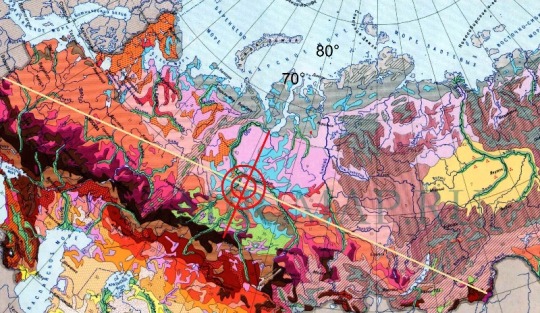
Plus or minus – about the 70th meridian. What would it mean? This is a question, a task that should be solved.

North of the past of the equator we will draw a parallel at 8 degrees. What do we see? – The chernozem strip is practically parallel to the equator and the eighth parallel. But still, some deviation to the south, to the equator, is – when approaching the equator of the shift (do not confuse the earth’s equator with the equator of the pole shift). Such deviation is explained an increase in the mudflow velocity when approaching the equator of the shift, which caused the demolition of chernozem near the equator of the shift to the south. East of the equator of the pole shift, the mudflow rate decreases and the soils washed away by it settle to the north, which is also seen on the map. We also pay attention to the fact that the line of the equator of the shift, passing near the 80th parallel, practically coincides with the axis of symmetry of the deviation of chernozems, which was determined at the very beginning. Thus, the soil map on the territory of the USSR is another proof of pole shifts. It remains only to show that the white line on the map corresponds to the equator line at -1, past the pole position. Such questions arose – it is better to remove them immediately. Equator line past

It would seem that this can be completed. But it is worth digging deeper.
Under the black soil. Under the black earth can be anything, but I am interested in loess rocks. What it is? Лёcc – an unusual rock. Loess strata lie down almost always near the surface (below the soil), have a light yellow or light brown (fawn) color. Loess contains more air than solid mineral matter. In other words, in it a lot of time. Many tubules are visible to the naked eye. Thickness of loess do not show appreciable stratification, exceptionally homogeneous. Under his fingers, it crumbles into powder, because it consists of dust particles with a diameter of one hundredth of a millimeter. It contains up to 7% of lime particles, and it boils from hydrochloric acid. In the dry state, loess is strong and capable of holding high vertical walls. Its name comes from the German word— "Unstable", "loose". However, dry loess is durable. But if it is moistened, then in this case its subsidence properties are manifested: the ability to decrease sharply in size under load (for example, at the base of engineering structures). Loess afraid of water. You have already understood that we are talking about mudslides, on the road, and they have a lot of it, ground to dust, as stated above, to hundredths of a millimeter. I.e, tens of microns. Again you guessed it would be nice to look at the map of loess rocks. Immediately put on it the line of the past of the equator
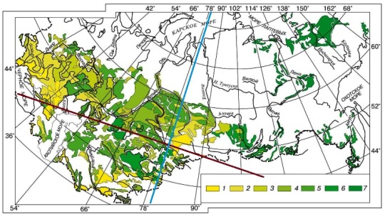
Less, however, will be heavier than chernozem – a donkey earlier. But he obeys the identified logic. One more. Remember that the line of the equator of the shift passing near the 80th parallel practically coincides with the axis of symmetry of the deviation of chernozems, but, nevertheless, it is 8 ° to the right. So it should be – due to the rotation of the Earth. Criticism, I understand, will be. By logic, as they say, you can only scare logicians. Обсерватория
Ссылка на русский текст по требованию.
0 notes
Text
An involuntary remark
The discipline of soil science is forced to coordinate such a basic parameter as the rate of soil formation with geological information about the duration of glacial epochs. When the glacier descends, the ice wasteland is replaced by a desert, the soil is stony and does not contain humus, which takes at least thousands of years to form. Here, soil scientists successfully refer to the C14 method to justify their conclusions. Soil scientists do not notice (narrow specialization) the existing conflict of the ice age, which geologists talk about. More about this:
Дисциплина почвоведения вынуждена согласовывать такой основной параметр, как скорость почвообразования, с геологическими сведениями о длительности ледниковых эпох. При сходе ледника ледяная пустошь замещается пустыней, почва оной камениста и не содержит гумуса, на образование которого требуются, по ТИ, тысячи лет. Здесь почвоведы успешно ссылаются на С14-метод для обоснования своих умозаключений. Почвопрофильные специалисты не замечают (узкая специализация) существующего конфликта леднивековья, о котором говорят геологи. Далее о нём:
Leland Horberg collected a lot of evidence detailing such things by comparing the retreat rates of ice sheets shown by radiocarbon dates with the current known ice speeds. The table compares radiocarbon dates of glacial phases with estimates of their age based on" normal " rates of glacier retreat..
Лиланд ��орберг, собрал много свидетельств, подробно описывающих схожее, сравнивая скорости отступления ледяных щитов, показанные радиоуглеродными датами, с современными известными скоростями движения льда. В таблице радиоуглеродные даты ледниковых фаз сравниваются с оценками их возраста, основанными на «нормальных» темпах отступления ледников..
Horberg believed that the radiocarbon Dating method was incorrect, since it led to conclusions about incredibly rapid processes of erosion and deposition during the ice age. The radiocarbon method, however, has been very well tested and is now considered very accurate, although errors sometimes occur with this method, as with all others.
Хорберг посчитал, что метод радиоуглеродного датирования неверен, так как он приводит к выводам о невероятно быстрых процессах эрозии и осаждения в ледниковый период. Радиоуглеродный метод, однако, был очень хорошо протестирован и теперь считается очень точным, хотя ошибки время от времени случаются и с этим методом, как и со всеми другими.
Read more here.
Подробнее здесь.
It is interesting that the rate of soil formation on real examples, in turn, contradicts the constants of the soil formers from TI and, further, with the C14 method itself.
Интересно, что скорость почвообразования на реальных примерах вступает, в свою очередь, в конфликт с константами почвообразователей от ТИ и, далее, с самим С14-методом.
It turns out that this method, on the one hand, simultaneously speeds up the geological history by orders of magnitude, and on the other - slows it down. Either this is the Golden mean, or it is a disciplinary strategy aimed at evolution in geological concepts: slow down billions to millions, and millions to thousands of years.
Получается, что этот метод, с одной стороны, одновременно на порядки ускоряет геологическую историю, с другой, - затормаживает её. Либо это - золотая середина, либо - дисциплинарная стратегия, имеющая целью эволюцию в геологических представлениях: спустить на тормозах миллиарды - до миллионов, а миллионы - до тысяч лет.
https://rodline.livejournal...
1 note
·
View note