#incredibly high on the limestone concentration front
Explore tagged Tumblr posts
Visit Tumblr Blog
Explore Tumblr blogs with no restrictions, modern design and the best experience.
Last Seen Tumblr Blogs


Fun Fact
There were a total of 171.5 billion posts on Tumblr in 2019.
Text
When I arrived to Arkis Rock, on the very outskirts of the continent, it was barren.
The isle is quite remote. It lies just beyond the Bastion Archipelago, safely ensconced in a position of complete strategic irrelevance. Though it was quite large for an island, the population, when I arrived, was a few hundred, concentrated in two fishing villages on the coast. The island was dominated by crags and forests, with a small mountain in the center where I was to make my castle.
It was exile, no doubt about it. I was too high-ranking to be tossed out like a common criminal, but that was cold comfort, this far from the mainland. There was almost no trade. The villages were impoverished. The villagers were growing inbred, for want of fresh blood. I and my retinue were the first outsiders they had seen in decades, aside from miscellaneous bureaucrats and officers who lived some way up the island.
The only thing that could have saved me was luck. And luck I had... for some measure of it.
The island had no economic potential. I could have perhaps attempted to open a mine, but without the assurance of something worthwhile in the rock I could not do so in good conscience. The soil was poor. The wood held no value for shipbuilding.
But then there was a book.
The official who owned it said that he had taken it from an older fishing family, whose health and fortunes had declined rapidly over the generations, in lieu of taxes, which they could not provide. Supposedly once they had been wealthy - the whole isle wealthy - but the money dried up. But there were no records which recorded the source of this fortune, nor memories remaining in the town of those days.
The book was unassuming. The paper had been manufactured from local reeds, and tore easily under my hands. Pages were missing, or ink smeared. Half of the whole, perhaps, was illegible or destroyed. And yet, in what remained, I found something quite curious.
The book bore reference to some old reef off the coast. Supposedly, if one sailed to this reef, and threw a sacrifice to the waves, one could draw something from the deeps. The pages describing what it was were missing, of course, but the effects were outlined clearly. One could extract youth and health, knowledge and power. And gold. And fish.
So I rowed out to the stormy seas, and threw a black cat into the water, and the next day, a chest washed up on the beach.
The chest alone could be worth a fortune. It was eerily ornate, covered in oceanic iconography and engravings of strange and coiling things in the deep. There was a starfish on its front, and gold framing the whole structure of the thing. The stone was a bleached white, like limestone, only incredibly dense. A chisel could not scratch it, nor pry the lid off, until I approached.
Perhaps what could have been inside was some terrible book, teaching dark rites one is not meant to practice. Or a trident, woven of enchanted gold, ominous, with seafoam green blood twisting and warping along its engravings. Or it could have just been gold, ever so much gold. But none of these were what was inside.
What was inside was a thing, which could open the lid of its own accord when I drew near, a thing with eyes and tendrils and beaks, and far too many teeth. And it chirped, a terribly discordant noise, in no tongue of man, no tongue my ears could even hear. And I bled, and I understood, and I began my work.
Honestly, I don't regret it much. When you look at it from a greater perspective, our lives are... insignificant. There are places men cannot dream of, heights that cannot be reached except with blood spilled. And though my acts were perhaps reprehensible, they were not unclean. I am purer than I have ever been.
And no matter how great an army you muster, to march upon my fortress, you cannot think to claim my life. For before it mixed its blood with mine, entered through my heart and filled the hungry void, I had already finished my door. And although I could have waited, stood at the threshold just long enough to look you in the eyes as I ascended, I am not a fool.
You will not find me here. But you may find my grail. And your army has quite a lot of fresh blood in it. And I have no doubt, at this point, that you know how to reach me.
You offended a high ranking noble and got reassigned to the remotest location possible. Two years later and this 'banishment assignment' has resulted in you becoming fabulously wealthy.
#woods writing#unsure of the quality of this one#the narrator was wealthy and prosperous at the midpoint of this innsmouth story#but gold doesn't matter#wealth is in the veins
3K notes
·
View notes
Text
Have you ever heard about Kornati Islands? Let’s make them your summer 2021 goal with a boat tour itinerary
Rugged, arid, and incredibly beautiful, the Kornati islands are ideal for those who practice sailing and decide to indulge in a relaxing holiday lulled by the waves. Here you will find almost uninhabited islands, beautiful secluded bays and peaceful nights to be enjoyed in the moonlight and stars.
CONTACT US NOW FOR YOUR CHARTER FROM SIBENIK
Would you like to know more? Follow us to discover the Kornati islands:
Where are we?
Our destination is located in Croatia, on the coast stretch overlooking the Adriatic Sea from the city of Zadar in the north to Sibenik in the south.
VIEW ALL THE BOATS BASED IN SIBENIK
The Kornati islands actually include three groups of northern Dalmatian islands: the northern archipelago of Zadar, the southern archipelago of Sibenik, and in the middle the islands that are part of the Kornati national park.
The park gives its name to a wider navigation area made up of countless islands and islets close to the Croatian coast.
How to get in Sibenik for your sailing itinerary around the Kornati?
The possibilities to reach this area are more than one. By air, it is in fact possible to land at the Zadar airport and then reach one of the many available marinas. Alternatively, it is possible to land further south, at Split airport, then moving north for about an hour of travel. In reality, it is also possible to reach the Kornati islands directly by sea departing from the port of Split (this won’t be our itinerary, however).
What is the best time to sail between the Kornati islands?
Being located north of the Mediterranean, Croatia offers its best in temperature terms during the summer season. From June to September the winds are constant but never too strong, if not due to a sudden storm. Sailing in this period it is also possible to avoid the famous “Bora”, a strong cold winter wind coming from the north.
While at the beginning and end of the season the temperatures are mild and not too sultry, during the peak months of July and August, daytime temperatures can consistently exceed 30 degrees Celsius.
Why sail from Sibenik?
Our itinerary departure and arrival port choice is the city of Sibenik. In addition to being about halfway along the Croatian Adriatic coast, in the Dalmatia region, and therefore being logistically an excellent position to reach the Kornati islands, Sibenik is located at the Krka river mouth and is a natural port connected to the sea by a channel of 2.7 km in length and on average more than 200 meters in width which allows navigation of even large ships.
That said, it is a modern town but with a lovely old town that offers points of cultural and architectural interest.
Here is our 7-day itinerary to the Kornati islands
Day 1: Žirje island
Zirje is part of the islets that make up the Sibenik archipelago. It is the largest island and also the farthest from the coast. This makes it the least visited and in fact here you can meet occasional explorers, walkers and some boaters in search of peace and serenity. The approximately 80 inhabitants take care of their gardens, poultry, and fishing.
Despite this, the main port, located in the eastern part of the island, has an excellent dock that can accommodate up to 20 boats.
Day 2: Zut island
Sailing north we meet Zut. The sea surrounding this island is a paradise corner where you can swim, dive for snorkeling or simply let yourself float surrounded by turquoise and emerald waters.
Zut is a fairly bare island with fields bordered by characteristic dry stone walls planted with olive trees, vines, and some fruit trees. The dry stone walls, one of the island’s main tourist attractions, go from sea to sea, crossing the whole island.
Day 3: Dugi Otok
Dugi Otok (or Long Island) is the largest and most famous island of the Kornati archipelago and is 45km long and up to 4km wide. The island is sparsely inhabited (3000 residents concentrated in 12 towns) and even in summer, it offers peace and tranquility. Dugi Otok is the ideal destination for those who prefer to spend their holidays sailing with the boat every day in a different place, in search of enchanting and particular corners or hidden beaches.
The island western part coast, the one facing the open sea, has high cliffs and bare limestone rocks that fall perpendicularly into the sea while in the southeastern part there are quiet bays and sandy beaches. Among these, there is Sakarun beach pictured in many postcards photographs portraying Dugi Otok.
Day 4: Iz island
The island of Iz is located in that channel formed between the islands of Ugljan, Rava, and Dugi Otok and is also surrounded by a dozen smaller islands.
Inhabited since prehistoric times, Iž is the only island in Dalmatia where the inhabitants are still pottery masters. Although today this ancient craft is slowly disappearing, artisans and shops still resist here where you can admire their work.
Day 5: Pasman island
Pasman Island beaches are of golden sand, the seabed is also sandy and the sea, in general, is shallow, the water is warm, clear, and crystalline due to the frequent change of currents and is ideal for inexperienced swimmers. and families with children, but it is also a paradise for those who love to explore by kayak, or with a mask and fins. The western part coast is instead the kingdom of divers.
The sandy beaches are concentrated in the northern part of the island, between the town of Tkon and the island of Ugljan.
Day 6: Kaprije
Kaprije is one of the must-see stops for every yachtsman who sails on the Kornati islands in front of Sibenik. It owes its name to the caper, a Mediterranean plant whose edible buds are useful in many traditional local dishes.
This island is the dream of those in search of that peace and silence that are increasingly unavailable elsewhere, and which here, on the other hand, are within everyone’s reach. On this islet, in fact, motor vehicles are banned, and only during the summer months, in the only inhabited center, do some tourists chatting resound.
Day 7: Primošten
Before returning to Sibenik‘s marina, we conclude our tour by heading to a southern coastal town: Primosten
Located in an isolated bay, Primosten is a suggestive peninsula made up of narrow alleys and bell towers, around which the promenade runs. Its medieval aspect is contrasted by a fascinating coniferous forest on the opposite side of the bay.
The whole Primošten is to be crossed in a long and relaxing walk to discover hidden corners that hide breathtaking landscapes.
Contact now YBH Charter Brokers:
You can contact us by sending an email at [email protected] or by phone, calling +39 33436 00997, available also on WhatsApp for both calls and texting.
#ipt_fsqm_form_wrap_7 .ipt_fsqm_form_logo img, #ipt_fsqm_form_wrap_7 .ipt-eform-width-restrain, #ipt_fsqm_form_wrap_7 .ipt_fsqm_form_message_restore, #ipt_fsqm_form_wrap_7 .ipt_fsqm_form_message_success, #ipt_fsqm_form_wrap_7 .ipt_fsqm_form_message_error, #ipt_fsqm_form_wrap_7 .ipt_fsqm_form_message_process, #ipt_fsqm_form_wrap_7 .ipt_fsqm_form_validation_error, #ipt_fsqm_form_wrap_7 .eform-ui-estimator { max-width: 100%; min-width: 240px; } /**/
/**/
Javascript is disabled
Javascript is disabled on your browser. Please enable it in order to use this form.
.ipt_uif_ajax_loader, .ipt_uif_ajax_loader *, ipt_uif_ajax_loader *::before, ipt_uif_ajax_loader *::after { box-sizing: border-box; }
Loading

FIND YOUR BOAT Go ahead, it's quick and simple
FIND YOUR BOATGo ahead, it's quick and simple
Select your boat Type(s)*
Motor YachtSail YachtCatamaranGulet
Departure*
Click here ×
Lenght of charter*
Week-end7 Days14 Days21 Days28 DaysOther
Where*
Just type the place you dream
Budget
Help us to find the best solutions for you0 - 25002500 - 50005000 - 1000010.000 - 20.00020.000 - 50.00050.000 -100.000+ 100.000
Write your name here
Write your e-mail address here
Write here
Get a quote!
Your form has been submitted
Thank you for your request. Our team will answer to you within 24 hours. I you have an urgent request then you can also call us on +39-3343600997.
Server Side Error
We faced problems while connecting to the server or receiving data from the server. Please wait for a few seconds and try again.
If the problem persists, then check your internet connectivity. If all other sites open fine, then please contact the administrator of this website with the following information.
TextStatus: undefined HTTP Error: undefined
.ipt_uif_ajax_loader, .ipt_uif_ajax_loader *, ipt_uif_ajax_loader *::before, ipt_uif_ajax_loader *::after { box-sizing: border-box; }
Processing you request
Error
Some error has occured.
Have you ever heard about Kornati Islands? Let’s make them your summer 2021 goal with a boat tour itinerary
March 27, 2021
Longing for the Caribbean? Discover our Antigua 7 Days Boat Itinerary!
March 26, 2021
Costa Blanca Boat Itinerary: What destinations can’t be missed while sailing this Spanish coast stretch?
March 25, 2021
Are you looking for an environmentally respectful holiday? What do you think about the Aeolian Islands for an eco-friendly sailing?
March 24, 2021
Share this Post
The post Have you ever heard about Kornati Islands? Let’s make them your summer 2021 goal with a boat tour itinerary appeared first on YBH.
from WordPress https://ift.tt/31rvbul via IFTTT
0 notes
Photo

(via Guanacaste National Parks) Guanacaste National Parksby admin | Jan 1, 2021 | national parks, Travel | 0 commentsNote: As of Dec 1, 2020 the following parks and reserves are open with restrictions – Arenal, Barra Honda, Ballena, Las Baulas, Braulio Carrillo, Cabo Blanco, Cahuita, Camaronal, Carara, Cipanci, Corcovado, Diriá, Gandoca-Manzanillo, Grecia, Guayabo, Iguanita, Irazú, Isla del Coco, Manuel Antonio, Monte Alto, Monteverde, Ostional, Poás, Los Quetzales, Rincón de la Vieja, Santa Rosa, Tapantí, Tenorio, Tortuguero, Turrialba.Map of Costa Rica’s Protected Areas
Leaders in ConservationCosta Rica’s National Parks and other protected areas serve as a model of sustainable conservation.The world owes Costa Rica a debt for the social conscience, political will, original economics, and plain old hard work that have led to the protection of a larger percentage of the land as natural habitat than in any other country.The incredible ecological diversity is recognized as an irreplaceable treasure by the people and government of Costa Rica and international organizations including the World Wildlife Fund, Conservation International, The Rainforest Alliance, Worldwatch Institute, Organization for Tropical Studies, MacArthur Foundation and the Nature Conservancy.Other countries including the United States, Canada, Sweden, Denmark, Germany, and Panama have also contributed much to the growth and protection of the wilds of Costa Rica with debt for nature swaps, grants, and scientific, economic and political expertise.National Parks DayEvery August 24th is Costa Rican National Parks day and entry into all parks is free for residents and international visitors!Palo Verde National ParkPalo Verde National Park has a unique dichotomous character. It’s simultaneously a spectacular wetlands and one of the best examples of tropical dry forests remaining anywhere in the world. This dual nature is a result of the Río Tempisque flooding over land located in a relatively arid climate region.The park, like many in Costa Rica’s system consists largely of reclaimed pastureland. Fortunately, in the case of Palo Verde, the haciendas that preceded the park were somewhat different than the clear-cut ranches of the volcanic highlands. The underlying limestone, and the drier climate of the region gave rise to native forests where trees were sparser and there was more grass and forage in the natural ecosystem. Clear-cutting was not always necessary to ranching, and the park escaped it’s tenure as pasture with less damage than most.Birds Dry Season and RainyBirds are the biggest attraction at Palo Verde National Park. In the wet season the floodwaters of the Río Tempisque spread to form extensive marshes that welcome migrant birds from the Americas at the onset of winter. As the December through May dry season (called summer in Costa Rica) progresses the marshes shrink to isolated patches and pools, and the migrants depart for their summer nesting grounds in temperate climates.Many of the resident tropical bird species nest on a small mangrove island in the Río Tempisque. Isla de Pajaros (bird island), as it is known provides a safe place for Cattle Egrets, Roseate Spoonbills, Wood Storks, Green-backed Herons, Anhingas, Great Egrets, and Black-crowned Night-Herons to breed. Other birds you can expect to see in the park include White Ibis, Glossy Ibis, Black-necked Stilt, Black-bellied Whistling-Duck, Snail Kite, American Widgeon, Northern Shoveler, and Blue-winged Teal.In the dry season, many of the trees have dropped their leaves, and the wildlife is concentrated around the ever-shrinking water sources. One of the best strategies for spotting the many species of mammals that Palo Verde National Park protects is to sit quietly near a water source. You may spot Variegated Squirrels, Howler Monkeys, White-nosed Coatis, White-tailed Deer, White-throated Capuchin Monkeys, and Collared Peccaries.Cycling Across the ParkPalo Verde National Park is one of our favorites. When we first visited, there was a little known and unused back entrance to the park, across the Bebedero river. We rode and carried our bicycles across the whole park to the campground near the ranger station (Read about Biking Palo Verde Park).The entrance and the trails it serves are now closed except for official research, but you can rent mountain bikes from the Organization for Tropical Studies station to explore other parts of the park.Getting to Palo VerdeAlthough the back door from Bebedero has been effectively closed, there is another very interesting way to enter the Park. On the Nicoya side of the Río Tempisque, you can hire a boat at the dock in the pueblo of Puerto Humo and power your way upriver to the Park. Arrange with your boatman ahead of time to get a close-up look at the Isla de Pajaros (Bird Island), and perhaps continue upriver past the park where the vegetation closes in and you are sure to see crocodiles.Best Time to VisitPalo Verde is located in one of the driest regions of Costa Rica but when it does rain here the roads can be impassable. Birdwatching is also better in the dry season because there are many migrants who arrive from up north to escape the snow in December through May.Stay in the Park – OTS Lodge and CampingThere are a few parks and reserves in Costa Rica where it’s possible to spend the night in relative comfort and thanks to the Organization for Tropical Studies, Palo Verde is one of them. Lodging, meals and guide services are all available by reservation (See details – OTS Palo Verde Lodge).If you’ve got the gear, camping is also an option. The campground near the ranger station provides access to potable water, showers and restrooms.Guanacaste National ParkMother with infant spider monkeys in the Murcielago sector of Santa Rosa National park on the trail to Bahia/Playa Hachal. Geoffroy’s Spider Monkeys (Ateles geoffroyi) are called mono aranya in Spanish and are also known as Black-handed Spider MonkeyGuanacaste National Park was created in 1989 to connect Santa Rosa National Park with the high elevation cloud forest of Orosi and Cacao volcanoes and across the continental divide to the Caribbean rainforest of Northern Costa Rica. The hope is that together these two parks protect enough land to ensure sufficiently large habitats for wide-ranging species such as jaguars and mountain lions, while simultaneously creating a biological corridor for birds and insects to make local seasonal migrations between the dry forest and the evergreen cloud and rain forests.The park owes its existence in large part to Dr. Daniel Janzen. He successfully raised donations telling international contributors he would show the world “how to grow a National Park.” He launched his campaign when international beef prices were low, and many of the ranch owners were eager to sell their degraded grazing lands. His goals of recreating more of the severely threatened tropical dry forest habitat from cattle pasture, as well as forming a biological corridor are now coming to fruition. Happily, biologists have commented that the habitat is regenerating more quickly than they had hoped.Janzen was also aware that the changes in the land that would benefit the wildlife would leave many ranch hands without work and have a major impact on local communities. His foresight ensured that one of the goals of the park is to encourage local participation in environmental programs, and train and employ locals as park personnel. This attitude is important, because although the National Parks of Costa Rica are part of the world’s heritage, they are also an important part of Tico’s everyday lives.Hiking, Nature Walks and BirdwatchingThe main attraction of Guanacaste National Park is a good brisk walk or a leisurely stroll. The large range of elevations result in trails that cross several ecosystems as you climb from the dry Pacific forests near the border with Santa Rosa National Park to the high elevation cloud forests near the peaks of Orosi and Cacao volcanoes. You can cross the continental divide and climb down to rainforest typical of the Caribbean side of Northern Costa Rica.Among the dry forest inhabitants are Collared Peccaries, Howler Monkeys, White-nosed Coatis, White-tailed Deer, and Variegated Squirrels, Long-tongued Bats, and Capuchin Monkeys. You will almost certainly spot dozens of birds in a hour or two of walking including White-throated Magpie Jays, Orange-Fronted Parakeets, and Crested Caracara (roadside hawks). At higher elevations you may spot Squirrel Cuckoos, Tanagers and Groove-billed Anis.rainfall and weatherThis is one of the hotter drier areas of Costa Rica, and the whole Guanacaste region has more predictable seasons than the rest of Costa Rica. The chance of rain is much less during the dry season from December to April, but the higher you climb, the more likely you are to get wet… any time of the year.Although it is fairly likely that it will rain on any given day during the rainy season (AKA the green season), it is also fairly likely that it will be a short shower in mid-afternoon. The rainy season which lasts from May until November is also usually interrupted by a two or three week dry spell in late July or August called the Veranillo de San Juan (Saint Joseph’s little summer).Quick Facts Guanacaste National ParkGuanacaste is a large park that protects 32,512 hectares where elevations range from 300 to 1659 meters (984 to 5443 feet). The habitats represented here are cloud forest, pasture/farm, and regenerating tropical dry forest.Santa Rosa National ParkTropical Dry ForestSanta Rosa National Park protects some of the last remaining tropical dry forest in the world. The small patch of oak forest near the entrance to the Comelco Ranch is probably representative of the original habitat of much of the park. Ranchers burned most of the plateau region, and African pasture grass (Hyparrenia rufa) and the fire resistant Bignoniaceae trees define the current landscape. Nearer the beaches the habitat becomes more native-like.Guanacaste National Park was created in 1989 to connect Santa Rosa National Park with the high elevation cloud forest of Orosi and Cacao volcanoes and across the continental divide to the Caribbean rainforest of Northern Costa Rica. The hope is that together these two parks protect enough land to ensure sufficiently large habitats for wide-ranging species such as jaguars and mountain lions while simultaneously creating a biological corridor for birds and insects to make local seasonal migrations between the dry forest and the evergreen cloud and rain forests.Beaches-Turtles, Scuba and SurfingThere are two important sea turtle nesting beaches in Santa Rosa, Naranjo and Nancite. The latter is one of two beaches in Costa Rica (the other is Ostional) where Pacific Ridley Sea Turtles come ashore each year in large arribadas to lay their eggs.These mass arrivals can include thousands of individuals in a single night, usually on a new moon in late summer.The beach at Naranjo is also famous for surfing, and the area near witch’s rock was a filming location for the cult surfing classic ‘Endless Summer II.’ There is a campground at Naranjo beach.From outside the park you can arrange scuba-diving trips to Islas Murciélago, (the Bat Islands), off the Santa Elena Peninsula.Hiking Trails and MapsThere are a number of excellent trails in Santa Rosa National Park for day or overnight trips.1:50,000 Topographical maps are available online from Omni Maps (sheets CR50 3048 I, and CR50 3048 IV cover most of the park, but CR50 3048 II, and CR50 3048 III are required for the southern edges)When to VisitThis is one of the hotter drier areas of Costa Rica, and the whole Guanacaste region has more predictable seasons than the rest of Costa Rica. The chance of rain is much less during the dry season from December to April.Although it is fairly likely that it will rain on any given day during the rainy season (AKA the green season), it is also fairly likely that it will be a short shower in mid-afternoon. The rainy season which lasts from May until November is also usually interrupted by a two or three week dry spell in late July or August called the veranillo de San Juan (little summer).Getting ThereLocation – Santa Rosa National Park is located at the northwestern tip of Costa Rica 118 miles (190 km) northwest of San José (136 miles, 219 km by road). Nearest towns Liberia & La Cruz.Driving directions – From San José, take the Interamerican Highway (1) north 136 miles (219 km) passing through San Ramon, Cañas, and Liberia to the signed left turn at the entrance road. Bus – Unfortunately there is not a direct way to reach the Santa Rosa Ranger Station by bus. Buses from San José or Liberia to La Cruz and the Nicaraguan border will drop you at the turnoff from the PanAmerican Highway and you’ll have to walk or hitch-hike the 4miles (7 km) to La Casona. Air – The nearest airport is LIR outside Liberia.Quick Facts Santa Rosa National ParkOne of Costa Rica’s larger parks, Santa Rosa covers 49,515 hectares with a wide range of habitats including beach, mangrove estuary, marine, pasture/farm, and tropical dry forest.History at Santa Rosa National ParkSanta Rosa may owe its early designation as a National Park to an attempted invasion by U.S. troops. The battle that occurred here is a source of great pride in Costa Rica, and the historical significance of the park helped win its protection by executive decrees in 1970 and 1977.William Walker was an American lawyer who had designs on an empire. In June of 1855 he arrived in Nicaragua, propped up a failing regime, and set him self up as Commander-in-Chief. With this tenuous authority, he planned to convert all of Central America into slaving territory and use the slaves to build a canal from Lake Nicaragua to the Pacific (the San Juan River is navigable from Lake Nicaragua to the Caribbean so this canal would have linked the Atlantic and Pacific Oceans as the Panama Canal does today).With the financial backing of the Confederate Union of the southern United States, Walker sent an international army of mercenaries into Costa Rica. When word of the invasion reached the capital, President Juan Rafael Mora organized 9,000 civilians to march to Guanacaste. At the hacienda of Santa Rosa on March 20, 1856, the mercenaries were routed in a 14 minute battle. The victorious Ticos pushed Walker’s forces across the border into Nicaragua where they made another stand in a wooden fort in Rivas. On April 11, 1856 a drummer boy named Juan Santamaría, from Alajuela volunteered to set the fort afire, and although he successfully flushed the mercenaries he lost his life in the battle. He is remembered as a hero.Walker returned to the United States, where he practiced law for a while before returning to Central America in another takeover attempt. In 1860, he was captured by the Honduran government, found guilty of treason and shot. Interestingly, another central figure in this history met a similar fate. President Mora lost political favor and his job after the battle. When he tried to regain control of the country in a military coup, he was captured, tried for treason and died in front of a firing squad the same year as Walker.Amazingly, this single incident encompasses much of the military history of Costa Rica. While Ticos are proud of their war heroes, and established Santa Rosa National Park in part to protect La Casona and the other buildings where the victory occurred, they are even prouder of their remarkably peaceful history.La Casona Hacienda was the site of the most famous battle in Costa Rican history. Now it’s a museum and part of Santa Rosa National Park. This historic building was the site of the ‘epic’ Battle of Santa Rosa in 1856 and has been preserved as a monument. There are displays of military paraphernalia and everyday life at a Tico Hacienda in the mid 1800’s. Keep an eye out for the Long-tongued Bats that roost in the eves of the buildings.Diria National ParkOne of Guanacaste’s Least-Known Attractions. Northern Guanacaste and the Nicoya Peninsula have several well known national parks: the history-rich Santa Rosa, the caves of Barra Honda, the marine preserve and turtle nesting grounds of Las Baulas and the wetlands of Palo Verde — now one of the top birding destinations in the world. But few know about or have visited the wonderful Diria National Park near Santa Cruz. It is the least visited locale in Costa Rica’s national park system, with even fewer tourists than the rarely visited La Cangreja Park, which was featured in the December 2018 Howler issue.The 5,500-hectare park (over 10,000 acres) was created only recently, in 2004. A key objective was to protect more than 380 species of trees that forest the area — many original old growth saved from the deforestation of the mid-20th century — as well as several rivers flowing out of the mountains creating the Santa Cruz region’s water supply. Diria National Park is also the home of rare and endangered bromeliads and cacti, along with a special group of orchids that can survive the extreme dry season conditions.For anyone visiting the northern Nicoya area, a day trip to Diria can give you a totally different Costa Rica experience.When to goIf you’re seeking a great place to hike or mountain bike, see lots of birds and animals along with rare and endangered plants or even just cool off from the heat, you will enjoy Diria. The park has two major areas: the lowland tropical dry forest around the casona (park ranger station) and the tropical humid forests covering much more mountainous terrain, rising to 1,800 meters (almost 6,000 feet) above sea level.The casona vicinity has three hiking trails that follow the rivers through the dry forest. The longest trail leads to beautiful Brazil Falls, requiring a demanding hike through rugged conditions. The park’s main facilities are located at the casona, accessible only by fording a river. Many opt not to drive through, especially in rainy season. The casona has restrooms and is equipped for overnight stays and meals if booked in advance, especially for groups.The rest of the park site can be reached by driving, or more recently, using a system of bike trails extending upward … and further up. You can drive to the crest of the Nicoya Peninsula’s highest mountain ridge, looking back to the mainland and even sighting Palo Verde National Park.
Animals and birds abound throughout Diria and change with the elevation. Howler monkeys, iguanas, anteaters and deer can be seen. Birding is also great here, with more than 140 species that include pale-billed woodpecker, barred antshrikes and long-tailed manakins. All are easily seen in the park, as well as the beautiful elegant trogon, which is found only in the northern Nicoya Peninsula.How to get thereFirst drive to Santa Cruz, from the west taking route 152/route 160 east, or from the east taking route 21. From there, take the road south to Arado; drive around the Arado soccer field and you will see a sign to Diria National Park. The road becomes gravel for the final 6 kilometers. Follow signs to Diria National Park (a 4WD vehicle is recommended). Signs to the park casona take you to the lowland trails (remember you must cross a river) and those marked Los Angeles lead up the mountain. When you reach the ranger station, don’t be surprised if it’s unoccupied; the park has few rangers and those on duty are likely out patrolling, especially when there’s a risk of forest fires during dry season. Many park visitors leave their admission fee on the desk.For anyone visiting the northern Nicoya area, staying in Tamarindo or other beach spots, a day trip to Diria can give you a totally different Costa Rica experience. It can even cool you off a bit, as a bonus for enjoying some real wilderness.When to visitAs applies to most places in Costa Rica, the best time for visiting Diria is between December to April. However, visiting in the rainy season can be a treat if you visit Brazil Falls, which quickly dries out in summer. The downside is that rainy season conditions can be difficult for getting around and the roads might be impassable.Rincón de la Vieja National Park, Guanacaste18 / 41Waterfall inside Rincon de la Vieja National ParkEcological diversity abounds at Rincón de la Vieja National Park, one of the parks in the Guanacaste Conservation Area.This park is a must-visit destination when you are in the Guanacaste Province.Best Hotels in Rincón de la Vieja National ParkPriceHotel Hacienda Guachipelin$$Check PriceAt over 34,000 acres, Rincón de la Vieja has room for two volcanoes, 32 rivers and streams, and an incredible variety of flora and fauna.A number of activities can be enjoyed at the park such as hiking, horseback riding, enjoying hot springs, swimming, picnicking, and camping. Rincón de la Vieja National Park VideoPlayUnmuteLoaded: 10.73%Remaining Time –2:53FullscreenGuachipelin Adventure Combo PassThe best all day adventure combo that includes ziplining, horseback riding, white water river tubing, full buffet lunch, hot springs & volcanic mud bath.Get Your PassRincón de la Vieja is approximately 15 miles northeast of the city of Liberia, which is the capital of the Guanacaste Province.Explore Both SidesWith its location and sheer size, this national park allows you to experience both the Caribbean and Pacific sides of the Cordillera de Guanacaste.The west side of the park on the slope of the volcano that fronts the Pacific Ocean is more arid than the eastern Caribbean-facing side, which means that it has a dry season from February through April.The dry season on the west side allows for great hiking conditions for those that want to hike the slope of the volcano. Atlantic trade winds on the eastern side of the park provide it with an average of 200 inches of rain per year, keeping vegetation lush and growing all the time.There is no distinct dry season on the east, so the tropical ecosystems on that side continually stay damp.The park is serviced by two ranger stations, one in the Santa Maria sector, and the other in the Las Pailas sector.Hiking and horseback riding trails fan out from the Santa Maria ranger station and traverse 5,000 feet in vertical elevation. Picnic areas are also available to rest and rejuvenate before hitting the trails again.Next to Las Pailas ranger station, campground facilities allow you to spend the night in the park.Rincón de la Vieja National ParkWhere to StayView HotelsSee Incredible Flora and FaunaRincón de la Vieja hosts a wide variety of tropical forests, including dwarf cloud and montane ecosystems.Exotic and rare flora and fauna find refuge here including kinkajous, pumas, a variety of monkeys, sloths, tapirs, and jaguars.Rare emerald toucanets and blue-crowned motmots glow in the sunlight along with vibrant fuschia and purple Guaria Morada orchids. Laurel and Guanacaste trees form canopies for birds and mammals to live in.Sightsee and SwimVarious water features are major attractions at the park and include a freshwater lagoon, waterfalls, hot springs, and boiling mud pits.Barra Honda Caverns National ParkThe area of the Tempisque Basin where the Nicoya Peninsula joins the mainland has a foundation of relatively soft limestone. Water has cut extensive caves through Cerro Barra Honda and the other small mountains creating the best know feature of this National Park. However, the park also has well maintained hiking trails. The protected tropical dry forest (though mostly secondary) within its borders is some of the last in the world, and very different from the rain and cloud forests that attract many ecological tourists to Costa Rica.The CavernsThe soda straws, pearls, roses, needles, cave grapes, curtains, terraces, stalactites, stalagmites and other calcareous formations of the more than 40 limestone caverns are the main attraction at Barra Honda National Park.The caves are all in relatively good condition because their vertical entrances are difficult to negotiate. This is also why you need climbing gear, a guide, and permission from the Parks service in advance to enter them.The caves range from a few feet to over 780 feet (240 meters) deep. Pozo Hediondo (Fetid Pit) Cave was named for the aroma of the guano deposited by thousands of resident bats.Until the caverns were discovered and explored in the late sixties, many believed that Cerro Barra Honda was a volcano because of the roaring sounds made by the bats as they departed the caverns en masse, and the fumes from the caves they occupied.Hiking at Barra HondaThe network of hiking trails used to access the caverns are great for exploring one of the rarest habitats on earth, tropical dry forest. The juxtaposition of capuchin monkeys and cactus seems odd, and some of the trees flower only after they’ve dropped all their leaves. Any time of year you can hope to see howler monkeys, deer, racoons, peccaries, kinkajous, agoutis, and anteaters.Maps are available at the ranger station. The main trail is an undriveable continuation of the entrance road that leads through mostly secondary forest to cerro Barra Honda (1,450 feet, 442 meters) where you are rewarded with spectacular views of the Tempisque valley.When to Visit and Where to Stay at Barra HondaThe caves are not open in the wet season because of the danger of flooding by the torrential rains that carved them from the stone. If you are a spelunker the dry season is your best bet.Cabinas and Camping – If you are traveling on a budget, spend the night. It’s one of the few places you can get a bed and a roof inside a National Park. At the ranger station a few minutes up a good gravel road from the entrance (closed from about dusk until 8:00 am) there are four rustic cabinas with bunks for six or eight each.These provide an excellent opportunity for travelers who don’t have either camping equipment, or the money for a lodge or ecocamp, to spend the night in the forest. When we stayed we had the place to ourselves and were on a hiking trail by around 5:15 am (about 15 minutes before sunrise) in order to catch the increased activity of the forest’s residents. We also felt comfortable walking on the broad main trail after dark, when you hear and see a whole new group of birds, insects and animals.There is a camping area next to the ranger station, across the road from the cabinas.If you don’t stay in the park, Nicoya is the closest alternative with lodging options in most price categories (nothing on the top end however).Getting ThereDriving directions From San José, take the Interamerican Highway (1) north just past the turn for Las Juntas de Abangares. Turn left on 18 towards San Joaquín and then follow the signs for the spur to the new Tempisque bridge. Once you rejoin the main road, continue southwest about 10 km then turn right towards the villages of Barra Honda and (also known as Nacaome) Santa Ana, and follow signs for the park entrance. The park headquarters is through the gate (closed at dusk) less than a mile up a good gravel road (4WD not required) on the left.Bus Unfortunately there is not a direct way to reach Barra Honda by bus. You can get a bus from San José to Nicoya, then there is one bus a day (12:30 p.m.) from Nicoya to Santa Ana which is about a 30 minute walk from the entrance.Daily departures from San José, Terminal Alfaro at 6:30 a.m., 8:00 a.m., 10:00 a.m., 1:30 p.m., 2:00 p.m., 3:00 p.m., 5:00 p.m., 156 km, 6 hours, $5.20, Alfaro Bus, telephone (506) 2222-2666Quick Facts about Barra Honda National ParkThe protected area is 5,600 acres (2,300 hectares, 8.75 square miles, 7 times the size of central park NYC) with elevations ranging from 20 to 442 meters (66 to 1450 feet). The habitats represented here are margin/edge and regenerating tropical dry forest.Hours The gate is open from 8:00 a.m. until dusk, if you are staying in the park, the rangers leave the station door open until they go to bed around 8:30 p.m.Hiking trails Maps are available at the ranger station. The main trail is an undriveable continuation of the entrance road that leads through mostly secondary forest to cerro Barra Honda (1,450 feet, 442 meters) where you are rewarded with spectacular views of the Tempisque valley.Habitats Tropical lowland dry forest, pasture, limestone caves.Tenorio Volcano National ParkQuite possibly our favorite national park. I know, I know, they can’t all be our favorite, but…Tenorio has everything you could want in a tropical forest natural area and every time we visit we find something new to love. Hiking to the sky blue Celeste waterfall is a highlight, but the hanging bridges in the rainforest and trail to Lago Danta through the cloud forest from the Heliconias entrance are equally amazing.For decades the area was nearly undiscovered but in 2018 twelve years of bridging river fords and improving roads culminated in the completion of the asphalt all the way to the park entrance. Visits exploded and by April of 2019 the park service was forced to impose quotas on the number of hikers and birdwatchers allowed on the trail.Celeste WaterfallAt a glance these are what puts the region around Bijagua on the list of the best places in Costa Rica. From ranger station at the west entrance of Tenorio National Park (El Pilón) to the azure tinted cataract a couple of kilometers to the south.You can make a loop out of the trail by continuing south to the teñiderios (Teñi de rios – dyeing of the rivers) then west along the other bank of the river to the hot springs and out to the road at the west entrance near Catarata Celeste Lodge. The road leads north to the new car bridge over the river and back to the ranger station.Hiking TrailsThe “Crater Hike” is only available with special permission along with an indigenous guide but well worth the extra effort.Main Park Entrance (El Pilón)The best way to experience the area, in fact the only way to see much of it, is on foot. You don’t have to be a Sherpa to visit the azure blue catarata río Celeste in Tenorio National park or the rainforest shrouded slopes of Miravalles volcano but you do have to walk because they’re only accessible by trail. Anywhere you walk in the area you’re likely to see birds and other wildlife (even in or near town).The hiking trail to Celeste waterfall and the other attractions around the main entrance is described above.Heliconias & Lago DantaThere is a little known entrance to the park at Heliconias Ecolodge Community Project. They have a network of excellent trails leading through their private protected forest to a series of hanging bridges through the rainforest canopy. On our last visit we went on the bridges trail under the stars and it was Awesome.Starting at the top end of the Canopy Bridges trail there is a 3 km spur that climbs up to the national park boundary and on to Lago Danta (Tapir Lake). We’ve never seen tapirs here but we’ve seen fresh tracks and they are more common here than nearly anywhere else in Costa Rica outside Corcovado National Park.There are also many abandoned or nearly abandoned roads where you can walk or mountain bike around Heliconias, Bijagua or any of the remote lodges and Miravalles National Park is literally right across the street.Natural Hot SpringsNOTE: In 2017 the park service closed the east entrance and the trail to the hot springs due to overcrowding.The hotsprings here really are natural. Commercial operations in the region have started the inevitable process of taming the geothermal mineral waters for spas and some of the pools in the National Park are off limits due to dangerously high temperatures, but there are still places along the lower Río Celeste where you can relax your tired muscles in completely natural hot springs (see map at bottom of page).For your own safety please respect all closures, warnings, and regulations posted by the park administration.BirdwatchingWe considered adding an extra star to the rating system just for this region because five out of five doesn’t really do it justice.Costa Rica is know for its incredible diversity of micro-climates, ecological zones and habitats and this valley between two volcanoes is a perfect example.The continental divide follows the slopes of volcán Miravalles down to the southeast to a point where Tenorio starts rising just outside Bijagua (in front of the Tenorio Lodge in fact). It’s not dramatic geographically and you won’t notice it as you’re driving or walking because the valley is quite broad here, but this dip in the continental divide is a mountain pass from the Caribbean slope to the Pacific.This creates a natural flyway from Lago de Nicaragua, Caño Negro and the other wetlands in the northern Caribbean lowlands to the Pacific coast and Palo Verde wetlands along the Río Tempisque. It seems unusual at first to see a flock of Roseate Spoonbills juxtaposed against the mountains but once you look a the geography it’s not surprising that this area hosts species from a wide range of habitats.Getting There and When to VisitNOTE: On April 11 2019 the National Park announced on its official facebook page that limits would be imposed on the number of visitors to reduce overcrowding. No more than 500 people will be allowed in the park at one time and no more than 1,000 per day.The map that’s linked above includes a zoomed out view showing the main ways to arrive in the area along with driving directions from Arenal volcano and the Pacific beaches.Bijagua is right on the continental divide and Tenorio National Park is split by it but tends to have more wet Caribbean/Atlantic climatic association than dry Guanacaste. It’s always possible it’ll rain but pretty unlikely it’ll be drenching downpours for extended periods.Tickets & Hours for Tenorio National Park/Celeste Waterfall Pilón EntranceThe Park is open every day (including weekends and holidays) from 8:00 a.m. until 4:00 p.m. The last entry is at 2:00 p.m.Citizens and Residents ¢800 ($1.20) Non-Residents $US12 Children under 12 are freeThere is no online ticketing or reservation system for Tenorio or the Celeste waterfall trail. Arrive early or join a tour group (agencies have access to advance purchase to guarantee entry).The town of Bijagua and the Tenorio region were directly in the path of Hurricane Otto on Thanksgiving Day 2016. Ten people were killed and couple of tiny communities in northern Costa Rica were devastated by the impact.The area is well on the way to a full recovery and one of the best things you can do to contribute to the local economy is visit and spend money! The Crater “Trail”The top of Tenorio Volcano and the trails leading to it are closed to the public. We entered by special permission with an authorized guide and a baquiano (indigenous guide) who knew the route across the wandering maze of tunnels through the elfin cloud forest at the top.If you have a chance to climb to the steep walled crater to the volcanically heated warm water lake at the top we highly recommend it. There is one trail that begins near the teñiderios west of the main entrance. It is clearly marked as off limits, nearly unused, and peters out into a maze of game trails after a few hundred meters.We entered through private property on the south side of the volcano and went by horseback for the first few kilometers across pasture. Once we entered the forest we tethered the horses and continued the ascent on foot.Because so few people are allowed into the area we were not surprised by the abundance of wildlife – even endangered and shy squirrel monkeys were calmly watching us from the tree tops.You can soak in a sulfuric hot spring a little under two miles down the trail and then enjoy a refreshing dip in a nearby waterfall or stream.Waterfalls with swimming opportunities are frequent along hiking trails. More evidence of geothermal activity in the area are the bubbling mud pools along the trail.Map of the Area
Click to enlarge map – Map of the AreaWitness Volcanic ActivityThe ancient Rincón de la Vieja volcano last erupted in 1983, with a minor ash and lava emission in 1991.Today, adventurous visitors can take a day-long hike to the top of the summit via a six-mile trail that originates at Las Pailas. The journey along the trail will reveal several different ecosystems. You will see Von Seebach, the main crater of the volcano, periodically spew steam as evidence of its geothermal activity.Those completing the hike will be rewarded with views of the Nicoya Peninsula and the Lago de Nicaragua.If the skies are exceptionally clear, you will be able to see Los Jilgueros Lake and almost all of Costa Rica. If you are considering taking the hike, be sure to bring adequate water to stay hydrated, and a warm water-resistant outer layer of clothing.In a country of national parks and wildlife preserves, the Rincón de la Vieja National Park is like no other in Costa Rica.You will long remember the wild flora and fauna in this premier park in the Guanacaste Province.CABO BLANCO ABSOLUTE NATURAL RESERVECabo Blanco Absolute Natural Reserve is located on the southern tip of the Nicoya Peninsula. This was the first national protected area in Costa Rica. It was created in 1963 prior to the national park system, which still carries on to this day. The reserve was created to protect the area from deforestation, mainly due to the efforts of the late Olof Wessberg, who collected funding from several European countries to enable the protection project. The closest towns to the reserve are Montezuma and Mal Pais.Create Your Perfect VacationAdventureAll-InclusiveRomanceBeach TimeSurfingNature & WildlifeOr call toll-free1-866-853-9426The Cabo Blanco Reserve protects 3,070 hectares or 7,586 acres of land. The elevation of the reserve ranges from sea level to 5 meters or 0 – 16 feet. It protects rainforest, beach, mangrove, and river habitats. There are several groomed hiking trails.The isolated reserve is home to plenty of wildlife. There are three species of large felines including margays, jaguarundis, and ocelots. Capuchin and howler monkeys represent the primates. In addition there are anteaters, armadillos, raccoons, kinkajous, pizotes, and deer. There are many reptiles including black and green iguanas, whip-tailed lizards, and boa constrictors. Many species of birds have been identified in the reserve such as scarlett macaws, crested caracaras, magpie-jays, long-tailed manakins, and elegant trogons. Along the shore, there are brown pelicans, sandpipers, frigate birds, brown boobies, and laughing gulls.Cabo Blanco Absolute Natural Reserve is government managed. The reserve is open from 8 AM – 4 PM, Wednesday through Sunday (closed on Mondays and Tuesdays). It has a ranger station that is equipped with basic amenities including public restrooms. The entrance fee to the reserve is $12 per person. There are no overnight facilities. Most visitors stay at hotels in Mal Pais or Montezuma.MORE ABOUT THE CABO BLANCO RESERVEThe reserve is in an ideal location for trees to flourish as it is located between tropical dry and wet forests. The park is home to over 140 different species of trees, including the wild plum, trumpet tree, lance wood, and the sapoditta – famous for producing the material that is used to make chewing gum.The reserve is famous for the white cape; a group of rocks located at the southern tip of the reserve that serves as a dwelling ground for a plethora of bird species. The two beaches of Cabo Blanco, Playa Cabo Blanco and Playa Balsitas are excellent locations to witness hundreds of pelicans as they soar while scouring for fish.There is a beach at the southern tip that has rocks with large fossilized oysters and other ancient marine shellfish. While these are quite a sight, you are not permitted to remove them.AT A GLANCERegion: Southern Nicoya Peninsula Closest town: Montezuma and mal Pais Size in hectares: 3,070 (7,586 acres) Year established: 1963 Elevation in meters: 0 – 5 (0 – 16 feet) Private managed: no Government managed: yes Rangers station: yes Overnight facilities: no Public restrooms: yes Entrance fee: $12pp Days: Wednesday – Sunday (closed Mondays and Tuesdays) Hours: 08:00 – 16:00 Hiking trails: yes Boat tours: no Average temperature range in Fahrenheit: 70 – 90 Average yearly precipitation in millimeters: 2,800 (110 inches) Habitat: mangrove, rainforest, beach, riverHOW TO GET THEREFrom San Jose, take Rt. 27 west to the Puntarenas exit. Take this exit, Rt. 17 west to Puntarenas and follow all the way to the ferry. Cross the Gulf of Nicoya on the ferry to Paquera. From Paquera, take Rt. 160 south to Cobano. Turn left on Rt. 624 and follow to Montezuma. From Montezuma, continue south on the dirt road passing through Cabuya and eventually to the reserve entrance. A four wheel drive vehicle is necessary on this road.WEATHER AND PACKING LISTThe reserve is located in a transitional area from rainforest to tropical dry forest. Day time temperatures regularly reach the low 90s and night time temps are usually in the upper 70s. The reserve receives an average of 2,800 mm or 110 inches of precipitation each year. The driest months are December through April and July.Visitors to Cabo Blanco should pack a bathing suit, towel, shorts, tee shirts, appropriate shoes, rain gear, sun block, and insect repellent. Visit our packing list for more ideas.Fun Fact: The blanco part of the name Cabo Blanco is a result of a section of cliffs and rocks which are permanently colored white due to bird droppings.Las Baulas National ParkToursLeatherbacks are the main draw for most visitors to Las Baulas National Park. Guides offer tours of Las Baulas National Park during leatherback nesting season (October 20 – February 15). Tours to see nesting leatherback turtles are always at night but actual times vary according to high tides. The total number of visitors is restricted to 30 persons per turtles (in groups of up to 15 persons each) and unregistered visitors are not allowed. To make a reservation, visit the Las Baulas National Park headquarters at Playa Grande or call (+506) 2653-0470, ext. 101 up to 8 days before the desired tour date to make a reservation. If you are unable to make a reservation prior to your arrival in country, we recommend visiting the Las Baulas National Park headquarters upon arrival to make your tour reservation in person. Please note that The Leatherback Trust is unable to make reservations for third-parties with Las Baulas National Park. We sincerely regret any inconvenience.Plan your visit around the typical nesting and hatching of each type of sea turtle.Visitors may be asked to wait at the park headquarters until scientists or park guards spot a turtle on the beach. The maximum waiting time can be up to 6 hours. Books, board games and snacks are great ways to pass the time. On some occasions, turtles may not appear on the beach and visitors may be sent home. Visitors are not charged unless turtle sightings are confirmed.© Kip Evans Photography | Mission BlueTo protect the turtles, visitors are reminded to always follow instructions from park guides and guards. Remember to keep a safe distance from nesting turtles and speak in low voices only when necessary. Flashlights and flash photography are restricted on the beach and visitors are asked to stay out of the turtle’s field of vision. Nesting turtles enter a trance as they lay eggs and visitors may see biologists measuring the length of the turtle’s carapace, checking for identification and counting the eggs. Scientists are unable to answer questions during this time, so visitors should direct questions to their local guide or wait until the tour is over. As soon as the nesting turtle begins to cover her nest with her front flippers, visitors are asked to retreat to allow her a full range of motion to camouflage the nest and return to sea.© Andrea Gingerich | Andipantz.comHelp HatchlingsVisitors can help protect turtles by following the rules and spreading the message of conservation. If you see turtle hatchlings on the beach, please keep dogs or other potential predators away and call a ranger at Las Baulas National Park headquarters at (+506) 2563-0470, ext. 101 or The Leatherback Trust’s team of biologists at Goldring-Gund Marine Biology Station at (+506) 2653-0635.© Andrea Gingerich | Andipantz.comOther ActivitiesApart from turtle tours, visitors are invited to surf, swim and enjoy the beautiful beaches of Playa Grande, Playa Ventanas, Playa Carbón and Playa Langosta. Many visitors enjoy snorkeling at Playa Carbón and kayaking in the bays. Please note that the beaches are closed at night to protect turtles during nesting season.© Andrea Gingerich | Andipantz.comThere is also excellent birdwatching in Ventanas Estuary or Tamarindo Wetland. Local guides spot crocodiles and monkeys on tours of the Tamarindo Wetland. Visitors can also schedule a wetland tour by calling Las Baulas National Park at (+506) 2653-0470, ext. 101.←12345678910→Take an Estuary TourVentanas estuary provides critical habitat for American crocodiles. Herons and roseate spoonbills nest in the Tamarindo estuary. Howler monkeys call as night falls.Images by C. Díaz-Chuquisengo 2014Share:Email thisTweet thisShare thisSee alsoConservationWe conserve the world’s most imperiled populations of sea turtles through research, habitat protection, education and advocacy.ThreatsLeatherbacks face different threats specific to each stage of their lives and the habitats they occupy during those stages. To save the leatherback, we must reduce threats in all habitats turtles occupy across their entire life cycle.Get InvolvedJoin us as a volunteer in Costa Rica or through our interactive exhibits online. Support our work by buying Leatherback Trust gear or making a donation today.The Leatherback Trust Inc. is a US 501(c)3 non profit organization – EIN 22-3741033Follow UsAdsenseLatest ListingsEl Castillo HostelHotel Paraiso del CocodriloCampamento Carey AsvoHotel Flying CrocodileFrank’s Secret Beer GardenChef RodolfoLocosCocos CevicheriaSand Dollar CoveJon Sandvik CabinCosta de OroWorld Reach SEO & Digital MarketingRandom ListingsEl Castillo HostelBoutique Hotel AnaYLas CatalinasOcean Course at Peninsula PapagayoVista Bahía Beach ResortHuetares Hotel & VillasWyndham TamarindoRipJack InnSharky’s Sports BarFeatured ListingsWorldReach SEOPlantacion Properties Tamarindo – Christie’s International Real EstateLa Locanda Ristorante PizzeriaTamarindo Luxury VillasJoin our newsletter!Full of tips, must-see spots, and things to do on your trip.JOINSubmit a CommentLogged in as admin. Log out?
0 notes
Text
Near-Death and Other Travel Experiences B- The Via Egnatia Roman Road across Albania (cont)
Day one: The first 10 miles of the long-distance trek from Golem and wild camping on a rock hard grass slope which even hardened steel tent pegs struggled to penetrate.
Day two
I was up at dawn as the man on mule came by this time with his blanket poncho packed away. I had seen him the previous night and he had slept about four hundred metres away in a dry gulley surrounded by trees. He gestured for me to follow him and pointed at another small cluster of trees about 400m away in the other direction. I did as I was bid as by now I was feeling less afraid of him. What he showed me was a shallow plastic tub which might have once held creosote or something like that. A rope was tied around the rim. He threw it down a half-metre wide hole in the ground and I heard it hit the water two seconds later. He waggled the rope and pulled it up again, and there was maybe a litre or so of water. He drank that, I guess, to show me it was safe and then threw the tub down again and then handed me the rope and got back on his mule and went on his way.I stripped down and got a wash, one litre of water at a time. Then drank a lot of water and then filled my water bottles. Oddly it made me feel like I was rich. Finding water and being set up for the day.
As I was packing up the tent the man came back on his horse, this time with a woman of a similar age to him who was carrying watermelons and grapes. She was dressed in a knitted woollen skirt and leggings which I found incredible given the heat which was already building. My guess is they were not related but I have no way of knowing. I tried to say the fruit was too big to carry but he insisted. The grapes gave me a little rush of energy and I set off walking. I walked all morning across open country, up and down hills in a sun-scorched landscape. All the streams were dried up or otherwise unsafe to drink from.
Late morning I came to the river I had been aiming for. Then walked half a mile up and down trying to find a crossing. The big difficulty was a fifty-metre thick barrier of thorn bushes between me and the water. Reluctantly I decided I had no choice but to get through it. I moved forward inch by inch over a period of about an hour: parting a way through the bushes and getting my hands, face and legs cut in the process. At one point I thought this was hopeless but going back looked just as daunting as going forward so I waited five minutes and inched my way forward again. I had lots of little streaks of blood running down me. Vicious flying insects I did not recognise were diving in like Spitfires in for a feast.
When the sun was nearing its highest I finally got through the wall of thorns. In front of me was a very steep slope down to a trickle of water at the bottom which was all the river was at this season. I have told many people this was a ravine which makes it sound like shinnying your way down the Grand Canyon. It was nothing like that but it was a fifty-foot drop through trees. My plan was to clamber down, moving from tree to tree, but the soil broke under me and I fell and ended up in a tree about halfway down. I was upside down with my rucksack hanging from my back and my legs twisted around some branches. The big fear in my head was I would snap my thigh bone and that would certainly mean that I would die there as I would not be able to move, I would get hit by physiological shock and blackout. I would probably never be found.
So I was getting these waves of terror but like Popeye, I reached for something to help...in my case cut watermelon I had in a plastic bag in my jacket pocket. I inched my way into a more stable position and then ate. I figured if I could concentrate on something else for a moment I would be okay. And that did work. For at least the next half an hour I performed a complicated chain of moves and inch by inch disentangled myself from the tree. I am a big fat XXXXXXX and no athlete at all. I soon knew there was a problem with my left knee and had to make the moves in little turns, then rest until the pain subsided. Once I got free I worked my way down the rest of the slope on my backside.
The next barrier was maybe five yards of mud. My left knee was painful but it could take my weight. The mud proved to be very deep and I lost one of my boots. It took a long time of balancing and swivelling to pull it out and I carried it the rest of the way in my hand. Very heavy. The scramble up the other side was exhausting but probably safer. At the top, I lay on the ground until some strength came back.
I had a hard time standing (it is really hard crawling on one knee) but pulled myself up by a tree. I hobbled along, caked in mud for the next hour or so. By now the heat was intense and there was no shade in sight. My body felt like it was emitting vast amounts of heat. I knew I was getting close to heatstroke and that this was scenario was dangerous for a fat old man. I saw a collection of buildings in the distance and set them as my target. When I got closer I realised it was a limestone quarry and felt totally hopeless as I figured it would be another disused site like many others that seemed to litter Albania. I was desperate to get some shade, so switched direction and headed for a cluster of trees by watch I assumed was another dried up stream bed. As I got closer the little site looked a lot greener than I expected. The trees gave good shade and the ground beneath them was covered in a deep bed of ferns.
My little book warned me about blood-sucking, crawling insects that lived in the country amongst wet grasses but by this time but I was past caring. I was craving to get something cool against my skin and to be out of the sun so just flopped to the ground and covered myself with fern leaves. Before I left home my then twelve-year-old grandson had gone to the camping shop at Blooms Garden Centre and bought me a block of Kendal Mint Cake, a high sugar content confectionary which hikers have always sworn by to give them a lift. I had planned to save it for emergencies but figured this situation qualified So I pulled the block out of my pocket and was determined to eat all of it in one go before I fell asleep…which I knew I was going to do. Unbeknown to me I had cracked my left knee cap. I could certainly feel my knee swelling but assumed this was just uncomplicated bruising.
Tomorrow. The last bit. Running up a mountain chasing a truck.
Photos.
Albania is a country of donkeys and/ or mules. I do not know one from the other. I got to love seeing them everywhere.
The landscape near the coast. It got more arid and treeless the further I got inland.
The famous Kendal Mint Cake, which gave me a lift just when I needed it.
Via Egnatia Foundation web page.


0 notes
Text
The question is: why?
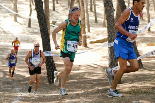
It’s Monday morning in Malaga, Spain, and I’m recovering from what turned out to be a very challenging 10 km road race yesterday. Without knowing my result, I had jogged back to my apartment, feeling less than satisfied with the whole exercise and seriously questioning whether the expense and travel hassles were really worth it. The problem was that the back end of my race had been poor, and that was what was fresh in my memory.
But let’s wind the clock back a few days. The journey from my front door to my accommodation in Torremolinos took 36 hours, a marathon in itself. There were four flights and three stopovers, so any sleep was fleeting at best. Nonetheless I felt OK on arrival and enjoyed meeting Andrew Kohlrusch, a decathlete from Sydney, with whom I would share an apartment for four days.
My first full day in Spain was the day of the cross country races. It was hot, really hot, but thankfully the course in a local forest was almost entirely shaded. It was dry, dusty and stony underfoot, not quite meeting the WMA rules which specify that World Championship cross country courses must be 85% grass! But I don’t think it rains much in Torremolinos. There isn’t much grass to be seen anywhere, so that rule was always going to be breached.
I cruised in my race, even finding time to smile for the cameras. The standard at the front of the race was pretty high. Two incredibly fit looking Kenyan athletes lined up for the start, but the other runners were quick to point out to them that they were in a later (younger) race, thankfully for us old geezers. One of these runners was Samuel Ndereba, who boasts a 10 km PB of 28:01!
Over the following three days, I did a road trip to the Altequera Natural Area, which featured a walking trail through impressive limestone stacks, watched the Melbourne vs Geelong game live on my computer (which I enjoyed somewhat), and then switched accommodation to Malaga.
Day 5 (Sunday) was race day. It dawned cloudy and fairly cool, which was good, but the cloud cover was patchy and bound to clear quickly. I jogged to the main athletics stadium where the race would start and finish. All the men aged from 30 to 70 would go off at 9.00 am, while the men aged over 70 and all the women would start at 9.10 am. The start was on the track itself, which meant that the 460+ men in my race were jammed in like sardines for several long minutes after the officials had pushed all the runners back behind the start line. On a humid and increasingly warm morning, the resulting body contact was most unpleasant for everyone.
Thankfully from the gun the runners fanned out across the track and there was a clean start. I settled in at a good hard pace and soon found myself locked on the shoulder of a Polish rival. I know that he was in my race because each runner’s bibs showed their age group. I felt that the pace was about right for my target of around 37 minutes, but I don’t look at my watch until 5 km. My judgment proved correct as I reached the milestone in 18:30.
Unfortunately from that point, the Pole began to get away and then an English 60+ runner passed me at around 6 km. It was getting much hotter as the cloud cover dissipated and the humidity seemed to rise. I was really finding it tough now. I concentrated on making sure that no other 60+ runners passed me, but a glance at my watch confirmed what I had feared was happening. My pace per km had slumped from 3:42 to the mid 3:50′s.
The stadium loomed ahead, thank goodness, but in a nasty twist, the course required us to go past it then do a full lap of the surrounding road. Finally we re-entered the stadium, did a full circuit of the track and finished. And when you are completely knackered, what’s the worse thing that could happen? Yep, some 60+ guy from Columbia tried to outsprint me in the last 30 metres. Well sorry fella, I might be stuffed but that ain’t gonna happen, and it didn’t. I later found out that although he had a race bib, he hadn’t entered the race, which was a trifle annoying, given the effort it had taken to beat him!
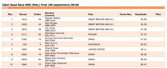
After the race, I tried to work out approximately where I’d placed by talking to the Pom who had overtaken me. It looked like sixth place was the best I could hope for, but I could well have missed out on the top ten, which had been another pre-race goal, given that on submitted times, I had been ranked around 15th fastest in the field.
Back at my apartment, I waited for the official results. Messages from home began arriving via Messenger, text and email, asking how I’d gone. Eventually they were posted on the championships website - sixth place, you beauty, my best ever placing in a World Championships. Suddenly I felt a whole lot better. Many congratulatory messages came from friends, which I loved receiving.
So the doubts which had surfaced on my jog home were banished and I look forward to my next race on Wednesday, which will be 5000m on the track. I had originally planned to do the half marathon next Sunday, but it is simply too hot and humid for this old runner coming straight from a Melbourne winter to endure 21.1 km of torture. It may even be too hot to run a decent 5000m, but at least I’ll only be out in the heat for a considerably shorter time.
And finally, to answer my own question: why? To quote Bruce Springsteen in his autobiography, there is still, after all these years “a furious fire in the hole that ... just ... don’t ... quit ... burning.” Hopefully it won’t go out for a while yet.
Until next time, long may you run (or, if you prefer, keep dancing in the dark).
#WMAC2018#worldmasters#worldmastersathletics#malaga#10kmrun#roadracing#roadrunner#mastersathletics#runblr#fitblr#athletics#running#distance running#health#fitness#Bruce Springsteen#torremolinos#halfmarathon#5000m#afl#melbournedemons#dees
0 notes
Text
Chattanooga Whiskey Co. - 1816 Cask Review

As promised, some words about Chattanooga Whiskey Co. and their 1816 Cask. I happened upon CWC’s regular 1816 Reserve when I was picking bottles for our starting lineup at BowTie Barbecue Co., my family restaurant. I wanted to have some staples, but also include smaller craft distilleries. One of my distributors brought by the 1816 Reserve, and I found it quite nice. That was about 4 months ago.
This past Monday I was reading about some of the best selling whiskies on one of these online bottle shops, and this the 1816 Reserve was their #1 seller! Well congrats to them. I revisited the bottle that afternoon, and sure enough: A great pour, especially for a $32 bottle of whiskey! I headed to one of my local bottle shops to grab a bottle.
And that’s where I found this guy, the 1816 Cask. Full disclosure, I am a huge Cask Strength or Barrel Proof fan. For those of you who may not be familiar, this is when a distiller takes the liquor that has been resting in the barrels and bottles is directly without proofing it (proofing being adding water to bring it down to a lower proof or ABV (alcohol by volume)). So I picked up this bottle. It was about $10 more than the regular 1816 Reserve, which makes sense: fewer bottles per barrel. And, spoiler alert, well worth it.
Now, normally I would go into a nice little education session about the distiller or NDP (non-distiller producer), but The Bitter Southerner did such a fantastic job in their article about them, I’m just going to include a link: Making Whiskey Chattanooga Style. In summation, Prohibition really screwed things up for folks trying to make beer, wine, and spirits here in the United States. Almost 100 years later, there are still some grotesquely antiquated laws floating around. Tim Piersant and Joe Ledbetter, two gents from Chattanooga, wanted to make whiskey...so they changed the laws.

Like a lot of new Whiskey Companies that are springing up, they couldn’t just begin making whiskey, so they starting buying already distilled (and sometimes aged) liquor from major distilleries in Indiana, Kentucky, and Tennessee. As you can see in the picture above, the label doesn’t say anything about these guys distilling the whiskey. They don’t even have “distillery” in their name, though the bottling company is called Tennessee Stillhouse. They do, in fact, have a still now, and are making their own whiskey. Just not 8 year old whiskey like in the bottle of 1816 Cask that I am drinking. These guys were up front about it, and that is admirable.

I came to find out that 1816 Cask is not a true cask strength whiskey as the CWC website states that its “a robust 113.6 proof blend, coming from barrels selected for their bold character and high proof cask notes.” I’m not sure why that process was chosen or if any proofing occurred, but I presume it is so they can say they had some hand in it’s creation.
Anyways! Let’s get down to the main event here. The tasting.
Serving: 1.5 ounces into a Glencairn glass.
Whiskey Type: American Whiskey
Proof: 113.6 (56.6 abv)
Age: Barreled in 2008 and bottled in March of 2016, so 7-8 years.
Cost: $42
Color: Burnt Orange, obviously a little darker than the 1816 Reserve since this is a more concentrated spirit.
Aroma: I Immediately get brown sugar and, to a lesser extent some molasses. There is also a maple syrup sweetness in there. Oak is very present with a medium char character coming through. Almost some cola notes floating around as well. Slight alcohol, but nothing overwhelming.
Palate: It’s almost like drinking strong sweetened black tea with a bite. There is almost a slight bitterness, but it is nicely countered by the sweetness...like strong sweet tea! Oak is also present, but kept at bay. There is a thickness to the mouthfeel, or fuller body for sure: something expected from the higher proof. As it leaves, the alcohol burn really comes in, but it is in no way overpowering, much like in the aroma. Like I said, I appreciate higher proof spirits, so the burn is welcome!
Finish: Nice, sweet, and lingering. The maple syrup comes back, as well as the oak.

I added about 30 drops of Old Limestone, limestone filtered water from Kentucky (more on this on a later date).
Water: Aroma doesn’t change all too much. The sweetened black tea comes up now, but aside from that, I don’t notice too much. Cherry syrup, cherry cola, and a hint of mint are unlocked in the palate. Wow. A definite change, but a welcome one. The sweet tea has completely morphed into that cola and cherry. The mouthfeel really hasn’t changed all too much, which is nice.
Value: For a mid-level whiskey, this is worth every penny to me. You get a higher proof for far less money than it’s competitors. With brands like Booker’s moving up to $100 MSRP, it is getting harder to find higher proof options below 60 dollars.
End of the Day: I’m obviously a fan. This whiskey has a lot of qualities I like: Higher proof, sweeter flavors, welcoming aromas, etc. This guy has won some awards, and I see why. While it wasn’t distilled on site, the blending of the barrels they selected and any further aging was done incredibly well.
For more information check out the website: Chattanooga Whiskey Co.
Cheers!
0 notes