#GNSS Receiver
Explore tagged Tumblr posts
Visit Tumblr Blog
Explore Tumblr blogs with no restrictions, modern design and the best experience.
Last Seen Tumblr Blogs


Fun Fact
Tumblr is available in 18 languages.
Text

#GNSS GPS Modules#GNSS Modules#GNSS Modules / Receivers#GNSS / GPS Modules#Highly accurate GPS/GNSS receiver modules#GNSS Positioning and Timing Modules for IoT#GNSS module Price#GNSS receiver#High accuracy GPS module#GPS/GNSS Receiver Chips & Modules#GPS / GNSS Modules#GPS/GNSS Receiver Module
0 notes
Text
Surveying Equipment
Get the surveying equipment you need to get the job done right. We have a wide variety of top-quality surveying tools for land surveyors, engineers, construction workers, and more. Shop our selection of trusted brands today to visit our site: https://www.amazon.com/SMAJAYU-Surveying-Equipment-Handheld-Channels/dp/B0BQ6WB3R4
0 notes
Text
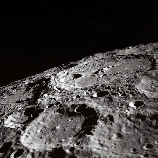
NASA and Italian Space Agency test future lunar navigation technology
As the Artemis campaign leads humanity to the moon and eventually Mars, NASA is refining its state-of-the-art navigation and positioning technologies to guide a new era of lunar exploration.
A technology demonstration helping pave the way for these developments is the Lunar GNSS Receiver Experiment (LuGRE) payload, a joint effort between NASA and the Italian Space Agency to demonstrate the viability of using existing GNSS (Global Navigation Satellite System) signals for positioning, navigation, and timing on the moon.
During its voyage on an upcoming delivery to the moon as part of NASA's CLPS (Commercial Lunar Payload Services) initiative, LuGRE would demonstrate acquiring and tracking signals from both the U.S. GPS and European Union Galileo GNSS constellations during transit to the moon, during lunar orbit, and finally for up to two weeks on the lunar surface itself.
The LuGRE payload is one of the first demonstrations of GNSS signal reception and navigation on and around the lunar surface, an important milestone for how lunar missions will access navigation and positioning technology.
If successful, LuGRE would demonstrate that spacecraft can use signals from existing GNSS satellites at lunar distances, reducing their reliance on ground-based stations on the Earth for lunar navigation.
Today, GNSS constellations support essential services like navigation, banking, power grid synchronization, cellular networks, and telecommunications. Near-Earth space missions use these signals in flight to determine critical operational information like location, velocity, and time.
NASA and the Italian Space Agency want to expand the boundaries of GNSS use cases. In 2019, the Magnetospheric Multiscale (MMS) mission broke the world record for farthest GPS signal acquisition 116,300 miles from the Earth's surface—nearly half of the 238,900 miles between Earth and the moon. Now, LuGRE could double that distance.
"GPS makes our lives safer and more viable here on Earth," said Kevin Coggins, NASA deputy associate administrator and SCaN (Space Communications and Navigation) Program manager at NASA Headquarters in Washington. "As we seek to extend humanity beyond our home planet, LuGRE should confirm that this extraordinary technology can do the same for us on the moon."
Reliable space communication and navigation systems play a vital role in all NASA missions, providing crucial connections from space to Earth for crewed and uncrewed missions alike. Using a blend of government and commercial assets, NASA's Near Space and Deep Space Networks support science, technology demonstrations, and human spaceflight missions across the solar system.
"This mission is more than a technological milestone," said Joel Parker, policy lead for positioning, navigation, and timing at NASA's Goddard Space Flight Center in Greenbelt, Maryland.
"We want to enable more and better missions to the moon for the benefit of everyone, and we want to do it together with our international partners."
The data-gathering LuGRE payload combines NASA-led systems engineering and mission management with receiver software and hardware developed by the Italian Space Agency and their industry partner Qascom—the first Italian-built hardware to operate on the lunar surface.
Any data LuGRE collects is intended to open the door for use of GNSS to all lunar missions, not just those by NASA or the Italian Space Agency. Approximately six months after LuGRE completes its operations, the agencies will release its mission data to broaden public and commercial access to lunar GNSS research.
"A project like LuGRE isn't about NASA alone," said NASA Goddard navigation and mission design engineer Lauren Konitzer. "It's something we're doing for the benefit of humanity. We're working to prove that lunar GNSS can work, and we're sharing our discoveries with the world."
The LuGRE payload is one of 10 science experiments launching to the lunar surface on this delivery through NASA's CLPS initiative.
Through CLPS, NASA works with American companies to provide delivery and quantity contracts for commercial deliveries to further lunar exploration and the development of a sustainable lunar economy. As of 2024, the agency has 14 private partners on contract for current and future CLPS missions.
Demonstrations like LuGRE could lay the groundwork for GNSS-based navigation systems on the lunar surface. Bridging these existing systems with emerging lunar-specific navigation solutions has the potential to define how all spacecraft navigate lunar terrain in the Artemis era.
The payload is a collaborative effort between NASA's Goddard Space Flight Center and the Italian Space Agency.
8 notes
·
View notes
Text

A mini GPS from uBlox with I2C and UART 🛰️📡🔧
The SAM-M8Q
is an entry-level 'all in one' GPS from uBlox - it comes with both UART and I2C interfaces plus a built-in antenna so it's ready to go 'out of the box.' It's also fairly small, so we decided to try and make a little breakout for it. It exposes both interfaces, but we expect most folks will like using the Stemma QT port for instant I2C interfacing. We gotta dig into uBlox's interface since we expect the I2C to be a little more complex than the PA1010 we've used.
#adafruit#gps#ublox#i2c#uart#sam-m8q#stemma#pa1010#electronics#gpsmodule#makerspace#hardwaredesign#embedded#opensourcetools#diyprojects#techinnovation#electronicsprojects#gpsbreakout#prototyping#smalldevices#sensorintegration#microcontroller#makersmovement
7 notes
·
View notes
Text
[ID: a reply and a Wikipedia screenshot. The reply is by msmc101 and says "the only reason I know about Trimble is because I watched bringusstudios shove steamos onto a Trimble yuma."
The Wikipedia page says "Trimble Inc. is an American software, hardware, and services technology company. Trimble supports global industries in building & construction, agriculture, geospatial, natural resources and utilities, governments, transportation and others. Trimble also does hardware development of global navigation satellite system (GNSS) receivers, scanners, total stations, laser rangefinders, unmanned aerial vehicles (UAVs), inertial navigation systems and software processing tools."
End ID]
yesterday I sarcastically made up the tech company names "Trimble" and "Plinq" and then to my horror discovered that both actually exist
31K notes
·
View notes
Text
Software Developer Lead (GNSS)
and government customers worldwide. Why join our team? As a Software Lead in the GNSS group, you will be involved in the complete… software development lifecycle of our GNSS receivers. The GNSS engineering team designs best-in-class systems and software… Apply Now
0 notes
Text
https://github.com/anushka224473/TrendMosaic/blob/main/North America GNSS RTK Receiver Market Drivers And Trends.md
0 notes
Text
0 notes
Text
GNSS Simulators Market Size, Share, Trends Overview & Demand Insights by 2032
The global gnss simulators market size is expected to gain momentum backed by the growing demand for advanced wearables across the globe. Additionally, the high demand for unmanned aerial vehicles across the military and defense sector is likely to propel the demand for advanced gnss simulators.
A gnss simulator efficiently emulates the surrounding of a gnss receiver across a dynamic platform by enabling vehicle and satellite motion, atmospherics, characteristics, and other effects. It propels the receiver to navigate as per the parameters set by the test scenarios.
Informational Source:
https://www.fortunebusinessinsights.com/gnss-simulators-market-103368

List of the Companies Operating in the Global Market for GNSS Simulators:
Accord Software & Systems (India)
CAST Navigation (The U.S.)
HyperTech (Israel)
IFEN (Germany)
IP-Solutions (India)
Orolia (The U.S.)
Qascom (Italy)
Rohde & Schwarz (Germany)
Syntony GNSS (France)
TeleOrbit (Germany)
WORK Microwave (Germany)
Jackson Labs Technologies (The U.S.)
M3Systems (France)
RACELOGIC (The U.K.)
Spirent Communications (The U.K.)
Among others
The market report includes a detailed analysis of several factors such as the key drivers and restraints that will impact growth. Additionally, the report provides insights into the regional analysis that covers different regions, contributing to the growth of the market. It includes the competitive landscape that involves the leading companies and the adoption of strategies by them to introduce new products, announce partnerships, and collaboration that will further contribute to the market growth. Moreover, the research analyst has adopted several research methodologies such as PESTEL and SWOT analysis to obtain information about the current trends and industry developments that will drive the market growth between 2024 and 2032.
Increasing Demand for UAVs to Propel Market Growth
The growing demand for optimum border monitoring, security, and surveillance purposes is driving the adoption of advanced UAVs. The increasing demand for strategic and tactical UAVs is expected to boost the adoption of advanced gnss simulators across the globe. Technological advancements have led to the development of wearable devices that are gaining popularity among consumers. Advanced gnss simulators offer total control over GPS signals that enable improved performance of the hardware and software of the wearable devices. As per the International Data Corporation report, around 336.5 million wearable devices were sold globally in 2019. This is expected to bode well for the global gnss simulators market growth during the forecast period.
Companies Covered in GNSS Simulators Market are:
Accord Software & Systems (India), CAST Navigation (The U.S.), HyperTech (Israel), IFEN (Germany), IP-Solutions (India) .Orolia (The U.S.), Qascom (Italy), Rohde & Schwarz (Germany) , Syntony GNSS (France), TeleOrbit (Germany), WORK Microwave (Germany), Jackson Labs Technologies (The U.S.), M3Systems (France), RACELOGIC (The U.K.), Spirent Communications (The U.K.) and Other key players
Growing Demand for Advanced UAVs in North America to Spur Growth
Among all the regions, North America is expected to remain dominant and hold the highest position in the global gnss simulators market in the forthcoming years. The dominance is attributable to the growing demand for unmanned aerial vehicles (UAVs) in countries such as Canada that will propel the adoption of advanced gnss simulators in the region between 2020 and 2027.
The market in Asia-Pacific is anticipated to experience considerable growth owing to the supportive government initiatives regarding space development activities that will boost the demand for technologically advanced gnss simulators in the region during the forecast period.
Product Innovation Key Focus of Major Companies to Consolidate Their Positions
The global gnss simulators market is experiencing considerable competition owing to the presence of major companies that are striving to maintain their dominance. These companies are focusing on developing innovative gnss simulators to strengthen their market positions. Furthermore, other key players are adopting strategies such as merger and acquisition, collaboration, and partnership that will contribute to the market growth in the forthcoming years.
November 2019 – Orolia announced the launch of GSG-8 GNSS/GPS simulator. According to the company, the device is an advanced timing test solution, navigation, and positioning simulator. Additionally, it will deliver optimum quality navigation satellite system signal testing and sensor simulation across the globe.
0 notes
Text
NASA and Italian Space Agency Test Future Lunar Navigation Technology - NASA
New Post has been published on https://sunalei.org/news/nasa-and-italian-space-agency-test-future-lunar-navigation-technology-nasa/
NASA and Italian Space Agency Test Future Lunar Navigation Technology - NASA
As the Artemis campaign leads humanity to the Moon and eventually Mars, NASA is refining its state-of-the-art navigation and positioning technologies to guide a new era of lunar exploration.
A technology demonstration helping pave the way for these developments is the Lunar GNSS Receiver Experiment (LuGRE) payload, a joint effort between NASA and the Italian Space Agency to demonstrate the viability of using existing GNSS (Global Navigation Satellite System) signals for positioning, navigation, and timing on the Moon.
During its voyage on an upcoming delivery to the Moon as part of NASA’s CLPS (Commercial Lunar Payload Services) initiative, LuGRE would demonstrate acquiring and tracking signals from both the U.S. GPS and European Union Galileo GNSS constellations during transit to the Moon, during lunar orbit, and finally for up to two weeks on the lunar surface itself.
[embedded content]
The Lunar GNSS Receiver Experiment (LuGRE) will investigate whether signals from two Global Navigation Satellite System (GNSS) constellations, the U.S. Global Positioning System (GPS) and European Union’s Galileo, can be tracked at the Moon and used for positioning, navigation, and timing (PNT).
The LuGRE payload is one of the first demonstrations of GNSS signal reception and navigation on and around the lunar surface, an important milestone for how lunar missions will access navigation and positioning technology. If successful, LuGRE would demonstrate that spacecraft can use signals from existing GNSS satellites at lunar distances, reducing their reliance on ground-based stations on the Earth for lunar navigation.
Today, GNSS constellations support essential services like navigation, banking, power grid synchronization, cellular networks, and telecommunications. Near-Earth space missions use these signals in flight to determine critical operational information like location, velocity, and time.
NASA and the Italian Space Agency want to expand the boundaries of GNSS use cases. In 2019, the Magnetospheric Multiscale (MMS) mission broke the world record for farthest GPS signal acquisition 116,300 miles from the Earth’s surface — nearly half of the 238,900 miles between Earth and the Moon. Now, LuGRE could double that distance.
“GPS makes our lives safer and more viable here on Earth,” said Kevin Coggins, NASA deputy associate administrator and SCaN (Space Communications and Navigation) Program manager at NASA Headquarters in Washington. “As we seek to extend humanity beyond our home planet, LuGRE should confirm that this extraordinary technology can do the same for us on the Moon.”
Reliable space communication and navigation systems play a vital role in all NASA missions, providing crucial connections from space to Earth for crewed and uncrewed missions alike. Using a blend of government and commercial assets, NASA’s Near Space and Deep Space Networks support science, technology demonstrations, and human spaceflight missions across the solar system.
“This mission is more than a technological milestone,” said Joel Parker, policy lead for positioning, navigation, and timing at NASA’s Goddard Space Flight Center in Greenbelt, Maryland. “We want to enable more and better missions to the Moon for the benefit of everyone, and we want to do it together with our international partners.”
JOEL PARKER
PNT Policy Lead at NASA’s Goddard Space Flight Center
The data-gathering LuGRE payload combines NASA-led systems engineering and mission management with receiver software and hardware developed by the Italian Space Agency and their industry partner Qascom — the first Italian-built hardware to operate on the lunar surface.
Any data LuGRE collects is intended to open the door for use of GNSS to all lunar missions, not just those by NASA or the Italian Space Agency. Approximately six months after LuGRE completes its operations, the agencies will release its mission data to broaden public and commercial access to lunar GNSS research.
“A project like LuGRE isn’t about NASA alone,” said NASA Goddard navigation and mission design engineer Lauren Konitzer. “It’s something we’re doing for the benefit of humanity. We’re working to prove that lunar GNSS can work, and we’re sharing our discoveries with the world.”
The LuGRE payload is one of 10 NASA-funded science experiments launching to the lunar surface on this delivery through NASA’s CLPS initiative. Through CLPS, NASA works with American companies to provide delivery and quantity contracts for commercial deliveries to further lunar exploration and the development of a sustainable lunar economy. As of 2024, the agency has 14 private partners on contract for current and future CLPS missions.
Demonstrations like LuGRE could lay the groundwork for GNSS-based navigation systems on the lunar surface. Bridging these existing systems with emerging lunar-specific navigation solutions has the potential to define how all spacecraft navigate lunar terrain in the Artemis era.
The payload is a collaborative effort between NASA’s Goddard Space Flight Center and the Italian Space Agency. Funding and oversight for the LuGRE payload comes from the agency’s SCaN Program office. It was chosen by NASA as one of 10 funded research and technology demonstrations for delivery to the lunar surface by Firefly Aerospace Inc, a flight under the agency’s CLPS initiative.
0 notes
Text
Auto Steer for Tractor

Automate your farming operations with Auto Steer for Tractor. Our advanced technology helps you get the most out of your land by optimizing efficiency and saving you time. With our easy-to-use system, you'll be able to get the job.
0 notes
Text
NASA and Italian Space Agency Test Future Lunar Navigation Technology
As the Artemis campaign leads humanity to the Moon and eventually Mars, NASA is refining its state-of-the-art navigation and positioning technologies to guide a new era of lunar exploration. A technology demonstration helping pave the way for these developments is the Lunar GNSS Receiver Experiment (LuGRE) payload, a joint effort between NASA and the Italian Space Agency to demonstrate the…
0 notes
Text

The global LiDAR Market was valued at $960 million in 2019, and is projected to reach $5.35 billion by 2030, growing at a CAGR of 16.9% from 2020 to 2030.
#LiDAR Market#Terrestrial#Aerial#Mobile#Short Range#LASER#Inertial Navigation System#Camera#GPS GNSS Receiver#MEMS#Corridor Mapping#Seismology#Exploration & Detection#Defense & Aerospace#Civil Engineering#Archaeology#Forestry & Agriculture#Mining#Transportation
0 notes
Text
NASA and Italian Space Agency Test Future Lunar Navigation Technology
As NASA celebrates 55 years since the historic Apollo 11 crewed lunar landing, the agency also is preparing new navigation and positioning technology for the Artemis campaign, the agency’s modern lunar exploration program. A technology demonstration helping pave the way for these developments is the Lunar GNSS Receiver Experiment (LuGRE) payload, a joint effort between […] from NASA https://ift.tt/c5mCFMq
1 note
·
View note
Text
GPS Systems: Unleashing the Power of Precision and Navigation
In today’s world, GPS systems are indispensable. Whether you’re navigating through city streets or trekking across remote landscapes, GPS technology has made it easier to find your way. But what exactly are GPS systems, and how do they work? Let’s delve into the fascinating world of GPS systems, exploring everything from how they function to their various applications.
What is a GPS System?
The Global Positioning System (GPS) is a navigation system that uses satellites to provide location data anywhere on Earth. The GPS network consists of a series of satellites that constantly send signals to GPS receivers on the ground, providing accurate location information.
Originally developed for military use by the United States, GPS technology is now a vital tool used across various industries for everything from personal navigation to fleet management and scientific research.
The Components of a GPS System
A GPS system operates through three main components:
Space Segment (Satellites) The space segment includes the GPS satellites that orbit Earth. These satellites continuously broadcast signals, allowing GPS receivers to calculate precise locations. There are currently 24 operational satellites, forming a GPS satellite constellation. These satellites are positioned to provide worldwide coverage, ensuring that at least four satellites are visible from any location on Earth.
Control Segment The control segment includes a network of ground stations that monitor the GPS satellites' positions and ensure their accuracy. These stations adjust the satellites' orbits if necessary and keep the system running smoothly.
User Segment (GPS Receivers) The user segment consists of the GPS receivers or devices that collect signals from the satellites. The receiver uses these signals to determine its location on Earth. GPS devices come in many forms, from handheld units to those integrated into smartphones, cars, and even wearable devices.

How Does GPS Work?
GPS systems work by triangulating signals from multiple satellites. When a GPS receiver picks up signals from at least four satellites, it calculates its distance from each one using the time it takes for the signal to travel from the satellite to the receiver. With this distance data, the GPS system can pinpoint the exact location of the receiver, including its latitude, longitude, and altitude.
This process happens almost instantaneously, giving users real-time navigation information.
Types of GPS Systems
There are different types of GPS systems, each designed to meet specific needs. Here are some common ones:
Standard GPS (Navstar GPS) This is the most widely used GPS system. It uses the network of satellites launched and maintained by the United States Space Force. It provides basic navigation and location services for civilian and military users.
Differential GPS (DGPS) This system improves the accuracy of GPS by using a network of fixed ground-based reference stations. These stations provide corrections to the GPS signals, improving accuracy to within a few centimeters.
Global Navigation Satellite System (GNSS) GNSS is a broader category of satellite systems that includes GPS. Other systems in the GNSS family include Russia’s GLONASS, Europe’s Galileo, and China’s BeiDou. These systems work in tandem, offering enhanced global coverage and reliability.
Augmented GPS (WAAS and EGNOS) The Wide Area Augmentation System (WAAS) and European Geostationary Navigation Overlay Service (EGNOS) are systems designed to improve GPS accuracy. They use ground stations to correct GPS signals in real-time, allowing for more precise positioning.
What is a GPS Satellite?
A GPS satellite is a highly specialized spacecraft designed to provide location data to GPS receivers on Earth. These satellites are positioned in medium Earth orbit (MEO) at an altitude of approximately 20,000 kilometers (12,427 miles). They travel at high speeds, completing one orbit around the Earth every 12 hours.
Each GPS satellite broadcasts a signal containing its current location and the time the signal was sent. By receiving signals from multiple satellites, a GPS receiver can calculate its exact position on the planet.
How Many GPS Satellites Are There?
There are 24 operational GPS satellites in orbit, though the total number of GPS satellites may vary as older ones are decommissioned and newer ones are launched. The U.S. government ensures that at least 24 satellites are operational at all times to provide reliable global coverage.
In addition to the 24 primary satellites, there are also backup satellites in orbit to maintain system redundancy and ensure uninterrupted service.
Applications of GPS Systems
GPS technology has countless applications in both everyday life and specialized industries. Some of the most common uses include:
Navigation GPS systems are used in smartphones, cars, and other devices to provide turn-by-turn navigation. This has made travel easier and more efficient, helping drivers avoid traffic and find the quickest routes.
Fleet Management Businesses with fleets of vehicles use GPS tracking systems to monitor their vehicles' locations in real-time. This helps optimize routes, improve fuel efficiency, and track deliveries.
Mapping and Surveying GPS is crucial in creating accurate maps, especially in remote areas where traditional surveying methods would be difficult. Surveyors use GPS systems to measure land accurately for construction, development, and scientific purposes.
Tracking and Monitoring GPS trackers are commonly used to monitor assets, pets, or individuals. This can provide peace of mind for people who want to keep track of valuable items or loved ones.
Agriculture GPS systems help farmers manage their fields more efficiently. By using precision farming techniques, GPS can assist with planting, irrigation, and crop management.
Military and Defense Initially developed for military purposes, GPS continues to play a critical role in defense operations. It aids in navigation, missile targeting, and coordinating military forces.
Emergency Services GPS is used by emergency services to locate individuals in distress. Whether it’s a car crash, medical emergency, or natural disaster, GPS systems can help responders find and reach the scene quickly.
GPS Accuracy and the Role of Multiple Satellites
One of the key factors in the accuracy of GPS systems is the number of satellites in view. The more satellites a GPS receiver can access, the more accurate the location data. Typically, a GPS system requires signals from at least four satellites to provide a precise reading. If only three satellites are available, the accuracy decreases, and the position is less reliable.
Factors such as the type of receiver, atmospheric conditions, and the presence of obstacles like tall buildings or mountains can also affect GPS accuracy. While standard GPS systems can have an accuracy of around 5 meters, more advanced systems like Differential GPS (DGPS) and GNSS can achieve accuracy levels within centimeters.
The Future of GPS Systems
As technology continues to evolve, GPS systems will become even more accurate and versatile. The launch of new satellites and the expansion of GNSS networks will provide users with even more reliable service. In the future, GPS systems may also incorporate new technologies, such as high-precision timing systems and integration with other satellite systems, to further enhance their performance.
Moreover, the development of new applications for GPS systems, such as autonomous vehicles and drones, will open up exciting possibilities for both consumers and businesses.
Final Thoughts
GPS systems are an essential tool in today’s world, providing accurate, real-time navigation and location data that power everything from daily commutes to critical emergency responses. With constant advancements in technology, the power of GPS systems will only continue to grow, shaping how we navigate the world around us.
From simple personal navigation to complex fleet management and satellite-based surveying, GPS technology touches many aspects of modern life. As we look to the future, GPS systems will remain integral to our ability to move through the world with precision and confidence.
5 FAQs About GPS Systems
What is a GPS system? A GPS (Global Positioning System) is a navigation system that uses satellites to provide location data anywhere on Earth, helping users determine their exact position.
How does GPS work? GPS works by receiving signals from at least four satellites. The receiver uses the time it takes for the signal to travel to calculate its location.
How many GPS satellites are there? There are 24 operational GPS satellites orbiting Earth, providing global coverage. Backup satellites ensure system reliability.
What is the difference between GPS and GNSS? GPS is part of the GNSS (Global Navigation Satellite System), which includes other systems like Russia’s GLONASS and Europe's Galileo, offering enhanced global coverage.
How accurate is GPS? Standard GPS accuracy is around 5 meters. However, systems like Differential GPS (DGPS) can improve accuracy to within centimeters.
0 notes