#Mount Assiniboine provincial park
Text

https://500px.com/photo/1093379064
18 notes
·
View notes
Photo

Mount Assiniboine Provincial Park turns 101 today! Here's a small selection of special moments I experienced there over the last few years. 🙏 — view on Instagram https://ift.tt/CIPVLcv
499 notes
·
View notes
Text


Jasper National Park, AB (No. 12)
The Athabasca River originates in Jasper National Park, in Lake Providence at the toe of the Columbia Glacier within the Columbia Icefield, between Mount Columbia, Snow Dome, and the Winston Churchill Range, at an elevation of approximately 1,600 metres (5,200 ft). It travels 1,231 km (765 mi) before draining into the Peace-Athabasca Delta near Lake Athabasca south of Fort Chipewyan. From there, its waters flow north as Rivière des Rochers, then join the Peace River to form the Slave River, which empties into the Great Slave Lake and discharges through the Mackenzie River system into the Arctic Ocean. The cumulative drainage area is 95,300 km2 (36,800 sq mi).
The river flows along icefields and through gorges, offering wildlife habitat on its shores and in adjacent marshes. Throughout its course, it flows through or adjacent to numerous national and provincial parks, including Jasper National Park, Fort Assiniboine Sandhills Wildland Provincial Park, Hubert Lake Wildland Provincial Park, La Biche River Wildland Provincial Park, Grand Rapids Wildland Provincial Park, Richardson Wildland Provincial Park, and Wood Buffalo National Park. Its course is marked by rapids, impeding navigation southwest of Fort McMurray.
Numerous communities are located on the banks of the Athabasca River, including Jasper, Brule, Entrance, Hinton, Whitecourt, Fort Assiniboine, Smith, Athabasca, Fort McMurray, and Fort McKay.
Source: Wikipedia
#Rocky Mountains#Northern Rockies#Alberta's Rockies#travel#original photography#vacation#tourist attraction#landmark#landscape#summer 2023#Canada#woods#forest#reflection#flora#nature#countryside#fir#pine#Jasper National Park#UNESCO World Heritage Site#Yellowhead Highway#Athabasca River
21 notes
·
View notes
Photo

(via Pinterest)
Mount Assiniboine Provincial Park, British Columbia, Canada
kevinmcnealphotography.com
26 notes
·
View notes
Text

Mount Assiniboine Provincial Park / Canada
by Jeff Wallace
11 notes
·
View notes
Text

Sunburst Lake, small lake in Mount Assiniboine Provincial Park in British Columbia, Canada
99 notes
·
View notes
Photo
Sunburst peak with Assiniboine on her left and The Marshall on her right. Mount Assiniboine Provincial Park, British Columbia [OC] [1024 x 768]
9 notes
·
View notes
Photo

Sunburst peak with Assiniboine on her left and The Marshall on her right. Mount Assiniboine Provincial Park, British Columbia [OC] [1024 x 768] https://ift.tt/ia8gyAB
2 notes
·
View notes
Text


Mount Assiniboine Provincial Park, Canada
© matt macpherson/500px/Getty Images
Featured on Bing- October 1, 2023
Mount Assiniboine Provincial Park, British Columbia
Featured on Bing- November 28, 2023
Mount Assiniboine Provincial Park, Canada
Whispers of winter
0 notes
Video
Assiniboine Sunrise (EXPLORED) by Renee
Via Flickr:
Explored October 30, 2022 www.flickr.com/explore/2022/10/30 The Mount Assiniboine rises at 3618 m above sea level, it is the highest peak in the Southern Continental Ranges of the Canadian Rockies. Access to Mount Assiniboine is either by helicopter or long hike in (30km one way). Spent three days in huts by taking helicopter in Mt. Assiniboine Provincial Park. After the snow in the dark early morning of the second day, afraid that the mountain climb would be slippery, so took crampons and climbed to the top of the mountain in the light of the headlamp.... This was the phenomenal panoramic views of Sunburst Peaks and Mt. Assiniboine with Lake Magog and Lake Sunburst. Climbed this mountains 4 times (5km one way), two dark early morning, two late afternoon, the sunrise and sunset sceneries were so different every time... The amplitude changed quite a lot on top of the mountains, the views were also different with the changing of the amplitude... Higher one with overall view, but the mountains were small compared with the lower amplitude one... More photos will come... 😉 Canon EOS R5, EF11-24mm f/4L USM ISO50, f/22, 11mm, 1s _______________________ Huge thanks for the visiting, faves and kind comments! 🙏💕 I appreciated your stopping by my dear Flickr friends! 🙏
#MountAssiniboine#Assiniboine#Canadian#Rockies#Huts#Sunrise#Snow#Mt.AssiniboineProvincialPark#Sunburst#Peaks#Lake#Magog#Nature#Travel#Landscape#Light#Canon#CanonR5#ReneeJiang#flickr
0 notes
Photo

Aurora over the Mt. Assiniboine
Mt. Assiniboine Provincial Park, Canada
by Jun Wang
#jun wang#photographer#canadian geographic#aurora#mount assiniboine#mount assiniboine provincial park#canada
2 notes
·
View notes
Photo

🌍 Mount Assiniboine Provincial Park, British Columbia, Canada | 📸 Tiffany Nguyen
#Mount Assiniboine Provincial Park#British Columbia#BC#Canada#north america#na#america#nature#travel#traveler#traveling#travelgram#explore#explorer#destinations#journey#road trip#trip#places#place#summer#adventure#wanderlust#outdoor#vacation#photography#travel photography#life#bucket list
382 notes
·
View notes
Photo

(via Pinterest)
The Base Of The Peak - Mount Assiniboine Provincial Park, BC, Canada by Kevin McNeal Photography
10 notes
·
View notes
Photo

Sunburst Peak in Cerulean Lake by jackbolshaw
1 note
·
View note
Photo

[source]
#mt assiniboine#mount assiniboine#canadian rockies#mount assiniboine provincial park#banff national park#alberta#british columbia#mountain#mountains#canada
1 note
·
View note
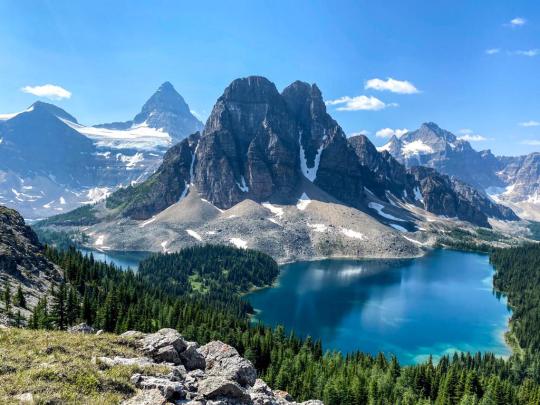
Photo

Sunburst Peak, Mount Assiniboine Provincial Park, Canada [OC] [7182x3954]
4 notes
·
View notes
Last Seen Blogs

nogonfriend
screeching

amandaiko
buat AmandAiko...

ortopedimerkezi-blog
İstanbul Ortopedi Merkezi

lua-dourada
NO CHAT

yakuza9293
İsimsiz